|
 Global Analysis / Global Hazards / United States / U.S.
Drought / Extremes
Global Analysis / Global Hazards / United States / U.S.
Drought / Extremes
Use these links to access detailed analyses of Global and U.S. data.

 Drought & Heat | Flooding | Storms | Tropical Cyclones | Extratropical Cyclones | Severe Winter Weather

| In the United States, a parade of Pacific storm systems ameliorated drought conditions in parts of the West, although areas of Wyoming, Montana and Idaho remained in exceptional drought. |

Larger Image
|
For comprehensive drought analysis, please see the current U.S. drought report.
 Larger Image Larger Image
|
Long term drought continued across southeastern Kenya and adjacent areas of Tanzania. Erratic rainfall in parts of Ethiopia and Eritrea resulted in poor crop conditions. For the latest African analysis and forecast, see the Famine Early Warning System Network.
|
| In Cambodia, as much as 10 percent of the rice crop was lost since October due to drought. Western Kampong Speu province was the worst affected, losing 90 percent of its crop yield. By mid-November, rainfall provided some relief to the short-term dryness (AFP). |
 Larger Image Larger Image
|
 Larger Image Larger Image
|
Across a large area of southern and eastern China, drought conditions were characterized as being the worst in more than 50 years (AFP). A prolonged dry spell ravaged parts of Guangdong, Hainan, Jiangxi and Anhui and provinces, as well as the Guangxi autonomous region. In Jiangxi province alone, drinking water to 620,000 people and 260,000 livestock was threatened (Xinhua).
|


| In the United States, heavy rainfall in Texas during November 15-18 was blamed for at least 2 deaths (Associated Press). Areas of the Texas Hill Country received 127 to 254 mm (5 to 10 inches) of rainfall during this period, producing widespread flooding. |
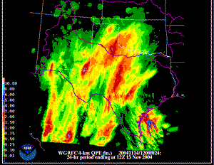 Rainfall in Texas Rainfall in Texas
|
 Larger Image Larger Image
|
In Colombia, heavy rains that began in October 2004 continued into November. Floods and/or landslides occurred in 24 out of 33 departments, where 19 people died and 34 were injured (OCHA). An estimated 240,000 people were affected, with 65,000 of these in the department of Bolivar. |
In Panama, intense rains fell in the upper watershed of the Chucunaque River in the Darien province during mid-November. Numerous river systems went above the flood stage, causing flooding in 25 communities. Over 7,500 people were affected with over 1,000 houses damaged, along with significant agricultural losses (OCHA).
For an archive of flood events worldwide, see the Dartmouth Flood Observatory.

| In the United States, an outbreak of severe thunderstorms on the 23rd produced reports of 54 tornadoes across portions of Texas, Louisiana, Arkansas and Alabama. In Texas's Hardin county, one person was killed with three injured when a tornado struck during the afternoon (Associated Press). |
 Radar Animation Radar Animation
|
 Flattened Trees In Slovakia Flattened Trees In Slovakia |
A severe windstorm affected areas of Poland and Slovakia during the 18th-19th. Winds exceeding 95 km/hr (60 mph) were common across much of Poland, where there were 7 reported wind-related fatalities (Disasterrelief.org). Farther south in Slovakia, wind gusts as high as 170 km/hr (105 mph) were reported. In the High Tatras Mountains, a 60 km long and 10 km wide belt of timber forest was completely destroyed. Widespread power and communication infrastructure damage was also reported (OCHA). |

 Larger Image Larger Image
|
Typhoon Muifa developed in the Philippine Sea on the 4th, attaining typhoon status by the 17th. Muifa crossed the central Philippines during the 18th-20th, with maximum sustained winds near 160 km/hr (85 knots or 100 mph). The typhoon was blamed for at least 61 deaths in the country (AFP). |
| Torrential rains occurred in central and southern Vietnam as the typhoon passed just to the south and entered the Gulf of Thailand. Flash flooding and landslides were blamed for 48 deaths in five provinces of the country (AFP/IFRC). Muifa dissipated just south of Bangkok, Thailand on the 26th. |
 Larger Image Larger Image
|
Following the passage of Typhoon Muifa, two more tropical depressions affected the Philippines during the 22nd-30th, resulting in over 1,000 deaths from landslides and flooding (Reuters). Of these fatalities, nearly one hundred occurred in the northern Philippine town of General Nakar (Reuters).
A table containing the Accumulated Cyclone Energy (ACE) index for global tropical cyclones occurring during the month of November 2004 is available.

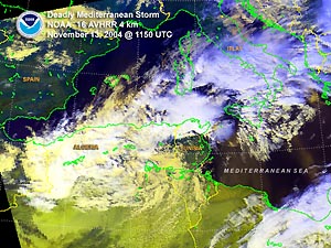
| A storm system that tracked off the coast of Algeria on the 13th brought strong winds and high seas to the western Mediterranean Sea. The storm was responsible for the sinking of an Algerian cargo ship while another Turkish vessel ran aground. Twenty sailors from both vessels were reported missing, with at least three fatalities (Reuters). The storm then tracked eastward across the Mediterranean, affecting Italy and the Adriatic Sea. In Croatia, winds gusting up to 200 km/hr (125 mph) toppled trees, damaged roofs and disrupted power and communications. There were dozens of injuries, and three people were reported missing in the sea (AFP) |
 Larger Image Larger Image
|

 Larger Image Larger Image
|
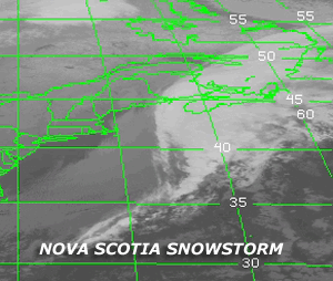
An early season blizzard pounded the Canadian Maritimes on the 14th, with 50 cm (20 inches) of snow blanketing much of Nova Scotia. Strong winds combined with the heavy, wet snow produced more than 100,000 power outages to homes and businesses, and temporarily closed the Halifax International Airport (Reuters). |
| Across Scandinavia on the 18th, an early season winter storm brought locally heavy snow and strong winds to much of the region. Snow accumulations of 20 cm (8 inches) were common throughout much of southern and central Sweden. Strong winds gusting over 100 km/hr (60 mph) combined with snow and rain to produce wind damage in parts of Norway and Denmark (BBC News). Farther south, the same storm system brought strong winds and locally heavy snowfall to parts of Germany, Austria and the Czech Republic. In Croatia, high winds were blamed for one fatality and widespread electricity outages. Heavy accumulations of snow temporarily closed the Czech-German border (AFP). |
 Click For Animation Click For Animation
|
References:
Basist, A., N.C. Grody, T.C. Peterson and C.N. Williams, 1998: Using the Special Sensor Microwave/Imager to Monitor Land Surface Temperatures, Wetness, and Snow Cover. Journal of Applied Meteorology, 37, 888-911.
Peterson, Thomas C. and Russell S. Vose, 1997: An overview of the Global Historical Climatology Network temperature data base. Bulletin of the American Meteorological Society, 78, 2837-2849.
For all climate questions other than questions concerning this report, please contact the National Climatic Data Center's Climate Services Division:
For further information on the historical climate perspective presented in this report, contact:
Scott Stephens
NOAA/National Climatic Data Center
151 Patton Avenue
Asheville, NC 28801-5001
fax: 828-271-4328
email: Scott.Stephens@noaa.gov
 NCDC / Climate
Monitoring / Climate
of 2004 / Hazards / Search / Help NCDC / Climate
Monitoring / Climate
of 2004 / Hazards / Search / Help
|


