 NCDC / Climate Monitoring / Climate of 2003 / Atlantic Hurricanes / Search / Help NCDC / Climate Monitoring / Climate of 2003 / Atlantic Hurricanes / Search / Help
Use these links to access detailed analyses of Global and U.S. data. 
|


|
As of December 12th, 16 named storms developed in 2003, which is well above the 1944-1996 average of 9.8, but consistent with a marked increase in the annual number of tropical systems since the mid 1990s (1995-2002 average = 13.3). Seven of the named storms were classified as hurricanes and three of those (Fabian, Isabel and Kate) were 'major' (category three or higher on the Saffir-Simpson scale). Two named storms (Odette and Peter) formed after the traditional end of the hurricane season (November 30th). This is the first year since 1887 in which two named storms are known to have formed in December. Tropical Storm Ana formed approximately six weeks before the beginning of the season on April 21st. This is also the first Atlantic storm on record in the month of April. With the development of Tropical Storm Peter in December, 2003 became the longest tropical cyclone season since 1952 when the first tropical storm formed on February 2nd and the last one dissipated on October 28th, according to the NOAA's National Hurricane Center.
Both Isabel and Fabian were very long-lived and instense storms in 2003 and there were five additional tropical depressions which did not reach tropical storm strength. Six storms impacted the coast of the United States. Tropical Storm Bill came ashore in Louisiana in late June and Hurricane Claudette made landfall as a category one hurricane in Texas in July. Tropical Storm Erika brought tropical storm conditions to South Texas though it actually came ashore in Mexico in August. Tropical Storm Grace also affected Texas in late August and Tropical Storm Henri made landfall as a tropical depression in September bringing as much as 10 inches of rain to west-central Florida. By far the largest impact in the United States from this summer's Atlantic storms was from Hurricane Isabel in September. Isabel came ashore in North Carolina as a category 2 hurricane and brought torrential rain and tropical storm force winds to a large area of the mid Atlantic coast. However, Isabel reached category 5 in the Atlantic, the first storm to do so since Hurricane Mitch in 1998. Additionally, Hurricane Juan maintained category 2 strength as it came ashore in Nova Scotia in September becoming the strongest hurricane to impact Halifax in modern history. There were no tropical storms in November, but two formed in December: |
 larger image |
Tropical Storm Odette formed in the Caribbean Sea on December 4th - the first tropical storm on record to have formed in the Caribbean Sea in December. Odette moved Northeastward while strengthening slightly to a maximum intensity of 55 knots, before coming ashore over the Dominican Republic on December 6th. Odette dumped up to 7 inches of rain before moving off the northeast and merging with a cold front moving off the coast of the United States. |
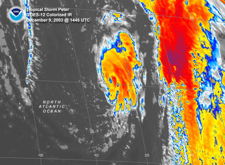
| Tropical Storm Peter formed on December 9th in the eastern Atlantic and initially moved southwest and south over warmer waters. Peter then intensified rapidly to a maximum intensity of 60 knots (just below hurricane strength) while moving north. However, Peter just as rapidly deteriorated to become a tropical depression on December 10th. | 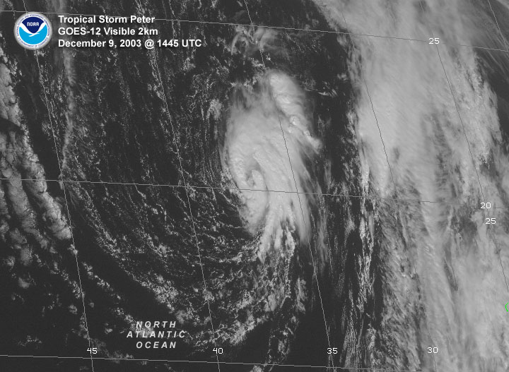 larger image |
 October
| Four named tropical systems, including one major hurricane occurred in October, compared to a long-term average of approximately one tropical storm and one hurricane for the month. Major Hurricane Kate formed in September and completed its lifecycle during October becoming 'major' during the early part of the month, and tropical storms Larry, Mindy and Nicholas also formed during October 2003. |
 larger image |
Hurricane Kate strengthened at the beginning of October after forming in the central Atlantic on September 25th. Maximum windspeeds of 125 mph were reached on October 4th while the hurricane was located about 640 miles east of Bermuda. Kate began to weaken over the next several days as it moved north and west and lost its tropical characteristics several hundred miles east-northeast of Newfoundland on October 8th. Still a powerful extratropical storm, Kate continued across the north Atlantic until it merged with a low pressure system close to Norway a couple of days later. |
| Tropical Storm Larry developed in the southern Gulf of Mexico on the 1st and trekked slowly southward into the Bay of Campeche, making landfall just east of Coatzacoalcos, Mexico on the 5th with maximum sustained winds near 85 km/hr (45 knots or 50 mph). Larry brought heavy rain to areas of Tabasco and Veracruz states, and prompted the temporary closure of two oil export ports of Dos Bocas and Pajaritos (Reuters). |  larger image |
September
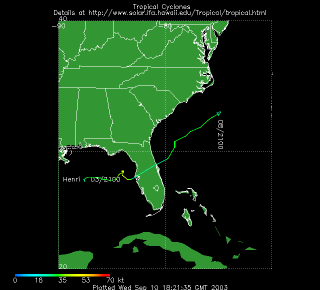
| Tropical Storm Henri developed in the eastern Gulf of Mexico on the 3rd and weakened into a tropical depression before crossing Florida on the 6th. The effects of Henri were minimal, with some localized heavy rain (up to 10 inches in west-central Florida) and gusty winds. Henri dissipated by the 8th. |
|
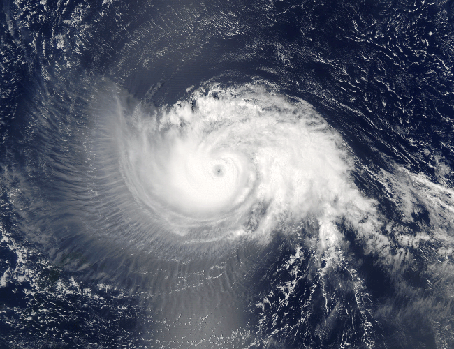
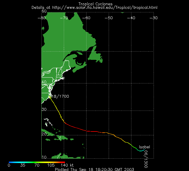
Hurricane Isabel: A tropical wave moving off the shore of Africa developed into Tropical Storm Isabel in the far eastern Atlantic, near the Cape Verde Islands on September 6th, 2003. The next day, as it moved west-northwestward, Isabel developed an eye and reached hurricane strength on the 7th. Conditions were very favorable for Isabel's continued development with warm sea surface temperatures ahead of it, low shear and an impressive outflow pattern from the storm. Rapid intensification occurred over the next several days and Isabel became a category 5 hurricane on the 11th. Isabel weakened slightly on the 13th, but did not weaken considerably until overnight on the 15th/16th when westerly shear began to affect the storm. Isabel decreased in strength to a category 2 storm, and eventually came ashore along North Carolina's Outer Banks on September 18th with sustained winds of approximately 85 knots - a minimal category 2 storm. |
 larger image |
 larger image |
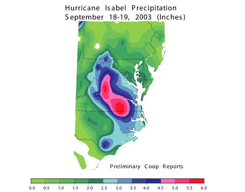
Preliminary estimates of Isabel's precipitation indicate that interior Virginia bore the brunt of the rainfall from Hurricane Isabel. The rainfall from Isabel did not lead to widespread flooding throughout North Carolina and Virginia. However, the unusually high precipitation totals in the months that preceded Hurricane Isabel resulted in very wet soils, and the combination of the wet conditions and strong winds associated with the storm led to downed trees and power outages for millions of people in the mid-Atlantic and Northeast.
Most of the flooding associated with storm occurred at the coastal margin. Hurricane force winds and a
storm surge of as much as 7-10 feet associated with Isabel led to a great deal of destruction at Cape Hatteras, NC, as well as along coastal Virginia and Maryland. Preliminary estimates suggest that 38 people died as a result of Isabel. A comparison between Isabel and 2 other major mid-Atlantic hurricanes of recent years is also available. |
| Hurricane Juan initially appeared to be subtropical in nature, but after forming approximately 295 miles southeast of Bermuda on September 25th, it moved to the north-northwest and was classified as fully tropical. Maximum windspeeds of 105 mph (91 kts) were reached on the 27th as Juan continued to move northward and made landfall in Nova Scotia, near Halifax the following day with somewhat weaker windspeeds. Juan was a category 2 hurricane at landfall - the strongest storm to hit Halifax in its modern history. Eight deaths have been attributed to Juan. |  larger image larger image
|
| Hurricane Kate began as a tropical wave approximately 900 miles west-southwest of the Cape Verde Islands on September 25th. The system became a tropical storm on the 27th. Briefly reaching hurricane strength on the 29th, by the end of the month Kate was located about 600 miles southwest of the Azores. More information on Kate can be found in the October section. |
August
 larger image |
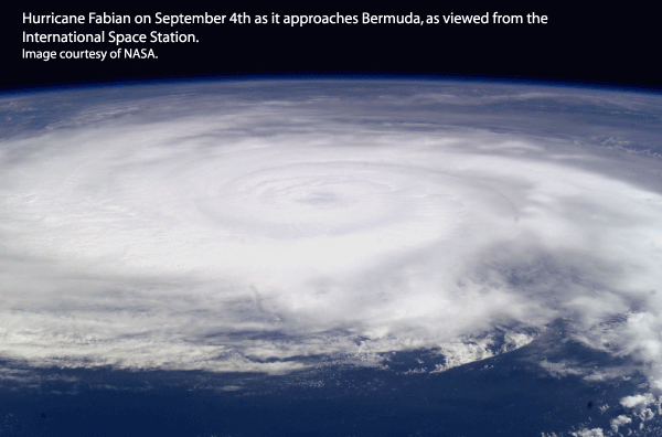
Hurricane Fabian
was the onl-y hurricane to develop during the month of August, though in total, there were four tropical systems that formed during the month. Fabian was the first 'major' hurricane of the season (category three or higher on the Saffir simpson scale), and eventually reached category four strength. The storm was a 'Cape Verde hurricane' developing on August 27th about 370 miles (596 km) west of the Cape Verde Islands. Tropical storm strength was reached on the 28th and Fabian became a hurricane on the 29th, reaching 'major hurricane' status on the 30th. Fabian reached category four strength on the 31st, but did not reach maximum windspeeds of 125 kts (144 mph, 231 kph) until September 1st. As the storm recurved in the western Atlantic, hurricane warnings were issued for the island of Bermuda and Fabian's eye passed very slightly to the west of the island on the afternoon of September 5th. Four deaths in Bermuda were directly blamed on the storm.
|
| Other named tropical systems in August were Erika and Grace, with short-lived Tropical Depression #9 also developing in the eastern Caribbean. TD #9 developed on August 21st from a fast-moving tropical wave. The depression dissipated south of Hispaniola the following day after moving west-northwestward. |
| Tropical Storm Grace developed at the end of August from a tropical wave which traveled across Mexico's Yucatan Peninsula and into the southeastern Gulf of Mexico on the 29th. The storm never became very organized, but was of tropical storm strength by the time it made landfall at Port O' Connor, Texas on August 31st with maximum sustained winds near 65 km/hr (35 knots or 40 mph). Heavy rainfall was the primary impact of Grace, with 50-130 mm (2-5 inches) common along parts of the Texas Gulf Coast. |
 larger image |
 larger image larger image
|
Tropical Storm Erika developed in the eastern Gulf of Mexico on the 14th and crossed into northern Mexico about 45 miles (70 km) southeast of Brownsville, TX in the United States on the 16th. Maximum sustained winds at the time of landfall were near 60 kts (110 km/hr or 70 mph). No significant damage or flooding was reported in south Texas, although trees were downed and roof damage occurred along the coast of northern Mexico (Associated Press). |
July
 larger image |
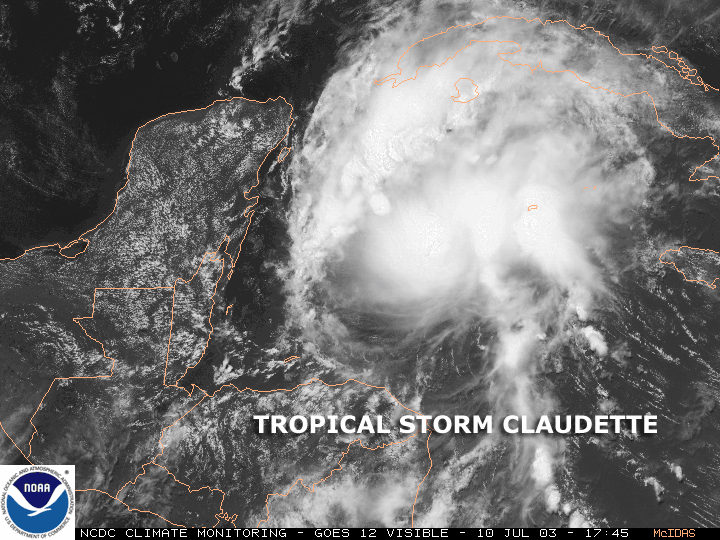
Tropical Storm Claudette
developed in the central Caribbean Sea on July 8th about 415 miles (670 km) east-southeast of Kingston, Jamaica. The storm strengthened and moved rapidly across the Caribbean Sea during the following 24 hours. Claudette maintained strength and moved west and then northwest before weakening as it entered the Gulf of Mexico, clipping the Yucatan coast of Mexico. It then moved very slowly through the Gulf of Mexico over the weekend of the 12th and 13th while gradually strengthening to reach category 1 hurricane strength late on July 14th. The first Atlantic hurricane of the season, Hurricane Claudette finally made landfall on the morning of July 15th around Port O'Connor, Texas, with maximum sustained winds at around 75 mph (120 kph/65 kts).
|
| The storm left two Texas residents dead and thousands without power along the central Texas coast before being downgraded to a tropical depression on the 16th. However, Claudette also brought welcome moisture to parts of Texas and the Southwest which had been dry. |
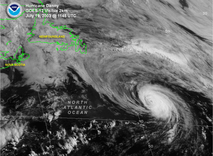
| Hurricane Danny began east of Bermuda as Tropical Depression #5 on July 16th and rapidly developed into a tropical storm later the same day. While posing no threat to land, Danny moved northward and then northeastward and became the second hurricane of the season on July 18th. Hurricane Danny weakened back to tropical storm status on the 19th as it tracked east-southeast across the North Atlantic. Tropical Depressions #6 and #7 also formed during July, but neither one was long-lived. TD #6 formed on the 19th and degenerated into a tropical wave by the 21st. Some thunderstorm activity was observed over the Lesser Antilles as a result of this system. TD #7 formed on July 25 and came ashore in Georgia on the 26th. Sustained winds were at 30 mph (48 kph/26 kts) at landfall and 2-3 inches (51-76 mm) of rain fell in parts of Georgia and South Carolina from the tropical system. |
 larger image |
June
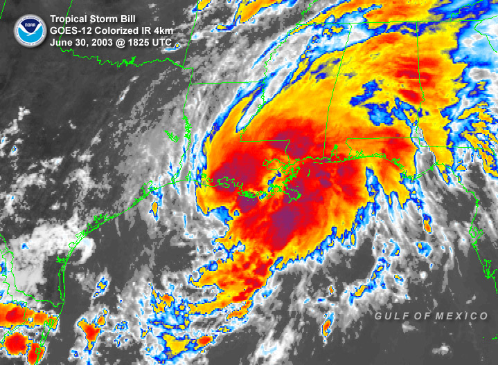
| Tropical Storm Bill rapidly developed in the Gulf of Mexico on Sunday June the 29th and came ashore in Southeastern Louisiana on Monday June 30th with sustained winds of 60 mph (97 kph/52 kts). Thousands of homes in Louisiana lost power during the storm and damaging rainfall amounts associated with Bill and its remnants caused flooding in states throughout the Southeast. At least 8 inches (203 mm)of rain fell in Pascagoula, Mississippi (on the border with Alabama) though rainfall and tornadoes also caused problems into Mississippi, Alabama, Tennessee, Georgia, North Carolina and Virginia. For further information on tropical systems affecting the Southeast U.S., go to the Southeast Regional Climate Center
Tropical Depression #2 also formed in the Atlantic on June 10, but rapidly degenerated into a tropical wave just one day later. However, it is only the third tropical cyclone to form east of the Lesser Antilles in June since 1967, according to the NOAA's National Hurricane Center. |
 larger image |
Pre-Season
 larger image |
The first tropical storm of the year, named Ana (shown left), formed more than five weeks before the official start of the hurricane season in 2003. The Atlantic hurricane season officially begins on June 1st, but a sub-tropical storm developed on April 20th and became a tropical storm on the 22nd. Maximum sustained winds reached 50 mph (80 km/hr, 45 knots) and the storm dissipated on the 23rd without nearing land. While tropical storms can form throughout the year in the North Atlantic, they are comparatively rare between the beginning of December and the end of May. Ana was the earliest storm of the Atlantic hurricane season since 1978 and the only tropical storm on record ever to have formed in April in the Atlantic Basin. According to NOAA's National Hurricane Center, the season's earliest Atlantic hurricane ever recorded was on March 7th, 1908, while the latest was on December 31st, 1954, which persisted into January 1955. |
Useful Links
- Saffir-Simpson Scale
- NOAA's National Hurricane Center
- Southeast Regional Climate Center - for tropical systems affecting the Southeast.
Questions?
For all climate questions other than questions concerning this report, please contact the National Climatic Data Center's Climate Services Division:
|
Climate Services Division NOAA/National Climatic Data Center 151 Patton Avenue Asheville, NC 28801-5001 fax: 828-271-4876 phone: 828-271-4800 email: questions@ncdc.noaa.gov |
For further information on the historical climate perspective presented in this report, contact:
|
Jay Lawrimore NOAA/National Climatic Data Center 151 Patton Avenue Asheville, NC 28801-5001 fax: 828-271-4328 email: Jay.Lawrimore@noaa.gov |
NCDC / Climate Monitoring / Climate of 2003 / hurricanes / Search / Help
Downloaded Tuesday, 16-Sep-2008 10:11:34 EDT
Last Updated Friday, 18-Nov-2005 14:11:55 EST by Anne.Waple@noaa.gov
Please see the NCDC Contact Page if you have questions or comments.