Viking 1 - 2
Full Name: Viking
Phase: Past
Launch Date: August 20, 1975
Mission Project Home Page: http://nssdc.gsfc.nasa.gov/planetary/viking.html
Program(s): Mars Exploration
The Viking Mars mission was performed by two spacecraft, Viking 1 and
Viking 2, launched within a couple of weeks of each other. Each
spacecraft consisted of an orbiter and a lander, which traveled
attached together for nearly a year to reach Mars orbit. The orbiters
then began taking pictures of the Martian surface, from which a landing
site was selected. The landers then separated from the orbiters and
soft landed. The orbiters continued imaging and, between Viking 1 and
Viking 2, imaged the entire planet at what was then high resolution.
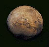
This mosaic of Mars is a compilation of images captured by the Viking Orbiter 1. The center of the scene shows the entire Valles Marineris canyon system, over 3,000 km long and up to 8 km deep, extending from Noctis Labyrinthus, the arcuate system of graben to the west, to the chaotic terrain to the east.
Image Credit: NASA/USGS
The orbiters also conducted atmospheric water vapor measurements and infrared thermal mapping. The Viking 1 orbiter flew within 90 kilometers of Phobos to take images of this larger, inner moon of Mars. The Viking landers took full 360-degree pictures, collected and analyzed samples of the Martian soil, and monitored the temperature, wind direction, and wind speed. The Viking missions revealed further details of volcanoes, lava plains, huge canyons, and the effects of wind and water. Analysis of the soils at the landing sites showed them to be rich in iron, but devoid of any signs of life.
The results from the Viking experiments revolutionized our view of Mars. Volcanoes, lava plains, immense canyons, cratered areas, wind-formed features, and evidence of surface water were seen in the Orbiter images. The planet was found to be divided into two main regions, northern low plains and southern cratered highlands. Superimposed on these regions are the Tharsis and Elysium bulges, which are high-standing volcanic areas, and Valles Marineris, a system of giant canyons near the equator.
The surface material at both landing sites was found to be an iron-rich clay. Measured temperatures ranged from 150 to 250 K, with a variation over a given day of 35 to 50 K. Seasonal dust storms, pressure changes, and transport of atmospheric gases between the polar caps were observed.
This mission is part of the Mars Exploration Program.