


 Obtaining Data
Please Cite Data Contributors!
Obtaining Data
Please Cite Data Contributors!
- Borehole Data and Climate Reconstructions from University of Michigan's (UM) Global Database
- List of Borehole Data by Title and Investigator
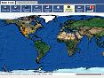
- UM Borehole Data Access using an ArcIMS GIS interface. Browse, query, and download data from an interactive map.
- Related Journals
Contributing data to the UM Global Borehole Database
- Contribute Borehole Data
- Add Papers to the Publications Index
- Register in the Borehole Researchers Directory
- Comments and Suggestions
More Information
- About the UM Borehole Database Project
- Geothermal Approach to Climate Reconstruction
- Index of Geothermal Publications
- Directory of Geothermal Researchers
- Other Internet Sites of Interest
Related Research
- Pollack et al. 1998 Climate change record in subsurface temperatures: a global perspective
- Huang et al 2000 Temperature trends over the past five centuries reconstructed from borehole temperatures
- Mann et al. 2003 Optimal Surface Temperature Reconstructions Using Terrestrial Borehole Data
- Pollack and Smerdon 2004 Borehole climate reconstructions: Spatial structure and hemispheric averages
- Rutherford and Mann 2004 Correction to Mann et al. 2003 Optimal Surface Temperature Reconstructions
- Huang 2004 Integrated Northern Hemisphere Surface Temperature Reconstruction