WORKING HYPOTHESES
- Numerical modelers can learn to incorporate more operational relevance
in their research efforts if they work closely with forecasters in an experimental
forecasting exercise.
- Operational forecasters can make more skillful interpretations of numerical
model output if they work with numerical modelers in an experimental forecasting
exercise.
SPECIFIC OBJECTIVES
Research perspective:
- To identify characteristic behaviors and specific
strengths/weaknesses of the different WRF configurations and provide focused
feedback to model developers on the performance of the experimental WRF models
during severe thunderstorm episodes.
- To evaluate the sensitivity of explicit
convective forecasts to grid resolution by comparing forecast with 2 km
and 4 km grid spacing.
Operational perspective:
- To evaluate the operational utility of several experimental high resolution
versions of the WRF model during severe weather episodes
- To
evaluate the ability of new methods to identify WRF model predicted
supercell thunderstorms and determine the correspondence between
model supercells and observed supercells
RESULTS
- Numerous systematic biases were identified in different configurations
of the WRF and linked to various physical parameterizations. Biases were
reported to model developers.
- The different WRF configurations performed with comparable skill in
predicting mesoscale aspects of convective initiation and evolution; there
was no clear advantage for 2 km grid spacing.
- Newly developed algorithms
appeared to be quite effective at identifying rotating updrafts in model
output.
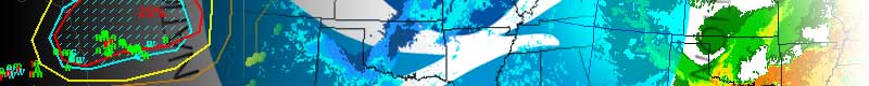
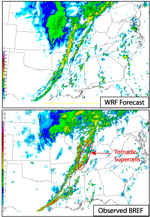
- Simulated reflectivity fields derived from model output revealed detailed
mesoscale structures that were not evident in traditional output fields.
PAYOFF
- Numerical modelers at NCAR and NCEP/EMC are mitigating systematic biases
revealed during the program, especially those associated with turbulence/boundary
layer parameterizations.
- SPC forecasters are becoming skillful users of convection-allowing
models. Experimental high-resolution model runs continue on a daily
basis at EMC and output from these runs has had a positive impact during
several severe weather outbreaks.
RELATED PUBLICATIONS
Koch, S. E., B. Ferrier, M. Stolinga, E. Szoke , S. J. Weiss, and J. S. Kain,
2005: The use of simulated radar reflectivity fields in the diagnosis of mesoscale
phenomena from high-resolution WRF model forecasts. Preprints, 11th Conference
on Mesoscale Processes, Albuquerque, NM, Amer. Meteor. Soc., CD-ROM, J4J.7
Kain, J. S., S. J. Weiss, M. E. Baldwin, G. W. Carbin, D. R. Bright, J. J.
Levit, and J. A. Hart, 2005: Evaluating high-resolution configurations of the
WRF model that are used to forecast severe convective weather: The 2005 SPC/NSSL
Spring Program. Preprints, 21th Conference on Weather Analysis and Forecasting/17th
Conference on Numerical Weather Prediction, Washington, D. C., Amer.
Meteor. Soc., CD-ROM, 2A.5.
2005 SPC/NSSL Spring
Experiment OPERATIONS
2005 SPC/NSSL Summer
Program OPERATIONS
SUMMARIES of previous SPC/NSSL Spring Experiments:
2007200520042003200220012000