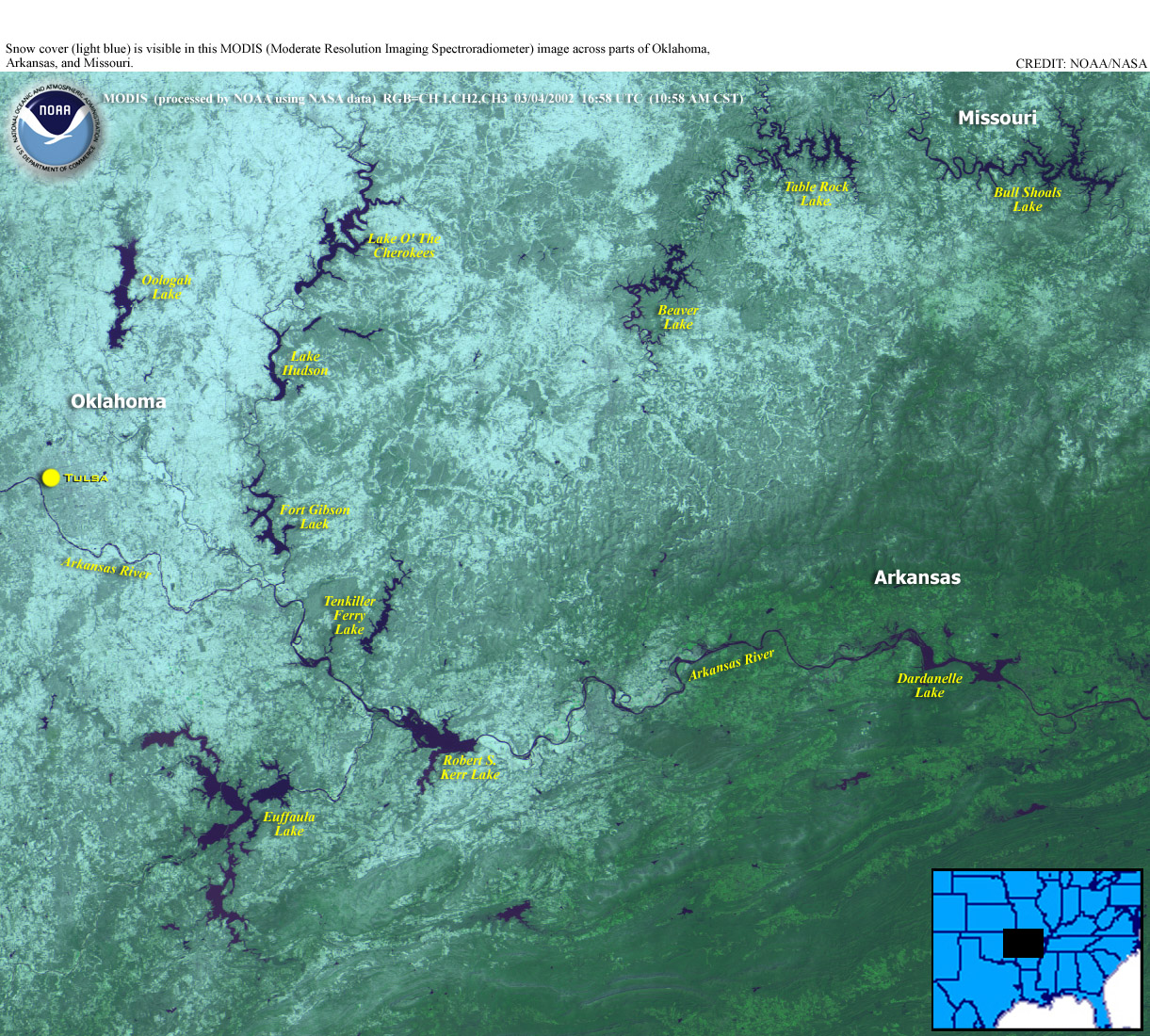
Department of Commerce logo

National Oceanic and Atmospheric Administration

Climate-Watch, March 2002

National Climatic Data Center - (last update April 05, 2002)


NOAA logo
Midwest Snowcover image

Midwest Snow cover image courtesy of NOAA/OSEI
(Click on the image for a larger view)


Separation bar

Top of Page Review

Early March Snowstorm in the U.S.

A snowstorm that swept from Texas to Michigan killed 21 people, according to media reports. On Mar. 2, sleet, snow and freezing rain contributed to more than 500 traffic accidents and about 100 cancelled flights at Dallas-Fort Worth International Airport. Authorities confirmed that in Texas, three died in weather-related traffic accidents and one died from hypothermia. Nine more died from storm-related causes in Oklahoma, five in Missouri, two in Colorado and one in Wisconsin, officials reported. The storm dumped heavy snow in Michigan on the 3rd, where 17.6 inches of snow fell in Marquette, and a one-day March record of 13.6 inches of snow fell in Grand Rapids. Milwaukee set a record on March 2 with snowfall accumulations of 9.4 inches while Sister Bay, Wisc., collected 13 inches of snow.


Weather Log - March 1-10th, 2002

As the seasons start to change, the United States typically sees an increase in severe weather with a corresponding increase in the frequency of tornadoes from March through the summer months. See the Storm Prediction Center for the latest severe weather watches and outlooks.

Meanwhile in the Indian /Pacific oceans there are three tropical systems to contend with at the beginning of March. See the U.S. Navy Joint Typhoon Warning Center .

According to UN reports, typhoon Mitag struck Yap Main Island for a few hours on 3 March. Maximum sustained winds were estimated at 95 knots (approximately 175 km/h), with gusts up to 115 knots (approximately 212 km/h). Most of the islands neighbouring Yap Main Island were also impacted by the typhoon. The atolls of Ifalik, Woleai, and Eauripik are reported to have sustained major damage, and others that were close to its path are also likely to have fared badly. There were no deaths or serious injuries reported, but destructive winds and a tidal surge destroyed nearly all the food crops in low-lying areas in the north, northeast, and southern parts of Yap Main Island, up to 400-500 m inland. The tidal surge brought many low-lying areas, including parts of Colonia (the main town), under water for several hours. Some 150-200 people lost their homes, and 129 of them are now being accommodated in temporary shelters. The coastline, the retaining walls and the food crops on Rumung Island, near Maap, in the north of Yap Main Island, were also extensively damaged by the storm surge, which went as far as 1,200 m inland.

NOAA scientists announced that ocean surface temperatures warmed 2 degrees Celsius (4 F) in the eastern equatorial Pacific near the South American coast in February. This warming has been accompanied by an increase in rainfall over that region, according to the agency's monthly El Nino forecasts and discussion. This warming is an additional sign the Pacific Ocean is heading toward an El Nino condition," said NOAA Administrator and Under Secretary of Commerce for Oceans and Atmosphere VADM Conrad C. Lautenbacher, USN (Ret.). "It's still too early to determine the potential strength of this El Nino or exactly what weather conditions it will bring to the United States, but it is likely these warming conditions in the tropical Pacific will continue until early 2003." See the complete NOAA story, "El Nino Continues to Develop" .

Weather Log - March 11-20th, 2002

Intense tropical cyclone Hary skirted Madagascar's east coast on the 10th, moving parallel to the Indian Ocean island. A spokesman at a forecast center in the capital Antananarivo said it looked likely the cyclone would remain at sea. As of March 11th, the storm was moving east-southeast away from the island. In 2000, more than 160 Madagascans were killed and tens of thousands driven from their homes by cyclones Eline and Gloria. As of March 12th, the storm was located 320 miles south of La Reunion island and is forecast to weaken slowly over the next few days.

An Alaskan snowstorm dumped 28.7 inches of snow on Anchorage, AK on March 16-17th, 2002. This snowfall broke the old daily record of 15.6 inches. Snow amounts ranged from 24 to 29 inches at lower elevations with 5 to 10 inches recorded along the upper hillside. Outside of Anchorage snowfall totals were light, with several inches of snow falling in southern Turnagain Arm and in the Matanuska Valley. Light snow began to fall in Anchorage at 5 pm on the 16th and continued through the evening of the 17th. The heaviest snowfall occurred between 10 pm on the 16th and 3 pm on the 17th, when 21 inches of snow was observed at the airport. Daily snowfall totals were 3 inches on the 16th and 25.7 inches on the 17th.

Seasonal Precipitation Rankings September 2001 - February 2002
larger image
Drought has intensified in parts of the eastern United States during the September 2001 - February 2002 period. Precipitation was associated with the main storm track which was from the south central states across the Mississippi and western Ohio Valleys and then across the central Great Lakes. States in those areas had average or above average precipitation. In contrast, areas to the east of that region, along the east coast, were very dry with drought intensifying. Note the difference in rankings between North Carolina and Tennessee.

The difference in rankings shown above across Tennessee and North Carolina is also apparent on the March 16-18th, 2002 accumulated radar precipitation map. Areas in east central Tennessee picked up over 7.00 inches of rain while the majority of North Carolina outside of the mountains saw less than one-half of an inch of precipitation.
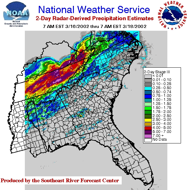
 Tennessee - North Carolina precipitation eventlarger image
An analysis of the event was also done using National Weather Service, cooperative station data and GLOBE schools in and near the region that received flooding rains. In this analysis note how the GLOBE student data compares favorably with the rest of the analysis. Also, note the axis of the precipitation was across eastern Tennessee into southwestern Virginia. Note the difference in precipitation amounts between Knoxville, TN and Asheville, NC. NCDC Station Precipitation Analysis Maplarger image
According to media reports, the National Guard was called in to help evacuate residents affected by a storm that damaged or destroyed at least 250 homes in the worst flooding to hit eastern Kentucky in 25 years. More rain is expected in parts of the region on the 19th and 20th. At least seven deaths in Tennessee were blamed on the storm, which dumped as much as 6 to 8 inches of rain.

See the following data summary for details on these storms.....

Rainfall Event, Mid March 2002

A massive sandstorm has enveloped most of northern China, covering the capital Beijing in a shroud of dense dust and reducing visibility to less than 50 meters in some areas. The storm is the strongest and most intense this spring, the official state-run Xinhua news agency reported, and hit China's north on the 19th with fierce winds. Sandstorms are frequent in spring, triggered by sudden seasonal temperature changes, Xinhua news agency reported. Sand is picked up from the expanding desert regions in northwestern China and Inner Mongolia. Dust storms choke northern China nearly every spring, often blown off the dry expanses of the Mongolian desert plain. But the problem has grown worse in the past 20 years because of deforestation and the increased drought across the north. The dust can be seen east of Beijing over the Yellow sea and the Sea of Japan.

Weather Log - March 21-31th, 2002

Flooding and landslides triggered by heavy rains have left 13 people dead and more than 6,000 people homeless throughout Ecuador. Torrential storms have drenched Ecuador for the past two weeks, causing rivers to overflow and flooding entire neighborhoods of towns and cities. Damage was worst in the coastal provinces of Manabi, El Oro and Guayas, where the country's second largest city, Guayaquil, is located. This type of event usually occurrs when water temperatures rise off the western South American coast and could possibly signal the return of El-Nino. See related story above.

Note: Hazard event satellite images available courtesy of NOAA OSEI Satellite Images WWW site.

Separation bar

Top of Page Selected U.S. City and State Extremes

The Selected U.S. City and State Extremes provides a list of new records that were set across the U.S. during March 2002.

Separation bar

Top of Page Additional Resources