 NCDC / Climate Research / Climate of 2000 / August / Climate-Watch / Search / Help NCDC / Climate Research / Climate of 2000 / August / Climate-Watch / Search / Help

|
 larger image |
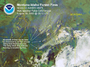
The enhanced NOAA satellite image to the left shows some of the smoke plumes associated with the forest fires across Montana and Idaho. The image shows both the visible smoke plumes and hot spots. Hundreds of fires can be seen on the image as evidenced by the whitish plumes rising from blackened areas. The numerous black dots on the image indicate burning or smoldering fires. |
Hurricane/Tropical Storm Debby weakened as it moved across the Carribbean for the latest update see, NOAA/NHC Tropical Prediction Center. As of 11AM EDT on the 24th, Debby was downgraded to a trough or open wave.
SuperTyphoon Billis crossed Taiwan and dissipated in southeast China on Thursday. Bilis devastated Taiwan on Tuesday (22) and Wednesday (23), claiming 11 lives, injuring at least 80 others, trapping 18 in mudslides and leaving 10 people missing. There were no storm-related causalities reported in China but Bilis caused mudslides and widespread flooding in both countries, and a mudslide damaged sections of a railway in southern China. The complete media report is available here.
In Nepal, landslides and flash floods triggered by heavy rains have killed seven more people in central Nepal taking the monsoon season's toll across the Himalayan kingdom since June to 122, an official said on Wednesday (23rd). Floods and landslides are common in Nepal during the annual monsoon season that continues through September. The complete media report is available here.
This summer's dry spell in north Texas became one for the record books Sunday (27th). It's been 50 years since the state last went 58 consecutive days without measurable rainfall. With no noteworthy rain on Sunday (27th), the region (Dallas - Ft. Worth area) tied that record, and forecasts showed it likely would break it on Monday (28th). The current dry spell began July 1, and more heat and sunshine are forecast for the region, said Joe Harris, a meteorologist with the National Weather Service. The complete media report is available here.
Monsoon rains washed away homes, roads and villages in eastern India during the past week, leaving people to drink contaminated flood water and eat snails and tadpoles. More than 300 people have died since the monsoon season began last month. Millions of people in three eastern states were left homeless by the rains, which had been typical of India's July-September monsoon season until recent days, when they became extremely heavy. In southeastern Andhra Pradesh state, meteorologists recorded 24 centimeters (10 inches) of rain -- the highest amount in more than five decades. The complete media report is available here.
Flooding had also taken its toll in South Korea during the last week (24th-28th) when useasonably heavy rain storms drenched most of South Korea. The hardest hit region was in the southwestern region where rainfall reportedly measured up to 22.8 inches.
The Bangkok Post reported on Friday (25th) that flash floods resulting from depression Kaemi hit several northeastern Thailand provinces yesterday (24th). Surin was reportedly badly hit, with several of its areas inundated with floodwaters, and two villagers swept away by currents - their bodies have not been found. Heavy rains reportedly occurred over Tha Tum, Chom Phra, Samrong Thap, Sikhoraphum, Sangkha and Muang districts, and many evacuations occurred. In Ubon Ratchathani, 8 districts were reportedly inundated, many roads became impassable and hundred's of rai of farmland were submerged. In the Warin Chamrap district 4 homes were reportedly swept away, while 10 other homes and 2 temples were damaged. According to a report by the Local Administration Department's Civil Defense Division flooding killed 2 people in the Trat province, while a total of 19,632 lives were affected and 8,932 rai of farmland and 8,160 rai of fruit orchards were ruined. The initial damage estimate for this province was reportedly 179,355,460 baht. In Trang 855 people were reportedly affected, schools were closed, and thousands of rai of rubber plantations were damaged. In Nakhon Ratchasima 40,000 rai of agricultural areas were reportedly damaged. Kaemi will now reportedly enter the province of Maha Sarakham, and according to the Northeastern Meteorological Centre flooding will occur in 10 more provinces. Flash floods have reportedly been predicted in Mukdahan, Amnat, Charoen, Yasothon, Roi-Et, Kalasin, Maha Sarakham, Buri Ram, Surin, Si Sa Ket and Ubon Ratchathani. A total of 41,219 people in 6 coastal provinces have reportedly been affected by flash floods over the past 7 days. The region has been quite wet during the last two months.
Fires also are making news in parts of Europe. The BBC reported Friday (25th) that a state of emergency has been declared in 2 southern districts in Bulgaria as nearly 70 wildfires have reportedly broken out in the past 24 hours. The fires are reportedly a result of an on-going heat wave and high winds. According to the Croatian Interior Minister (CIM) a loss of 150 million kuna, or 17.75 million dollars U.S., has occurred as a result of the hundreds of fires that have occurred this year in that country. According to the CIM high temperatures and drought are responsible for the fires, and they are reportedly continuing to spread as a result of bad weather. Various media sources reported that officials have declared a state of emergency for the southern Arcadia province as more than 80 wildfires burn out of control in Greece. Heat and high winds are reportedly responsible for fires that killed 2 people Thursday (24th) near the northern village of Aghia Marina, and 5 more individuals, in 3 other villages, on Friday (25th) . The blaze responsible for these deaths reportedly originated in Albania and had a front approximately 25 metres long. In addition, the fires in Arcadia have reportedly been burning for 5 days, and are threatening a hydroelectric plant as well as destroying thousands of hectares of forest and farmland, and engulfing numerous homes.
Media reports indicated on Monday (28th) that Iraq is suffering from a severe water shortage and has endured 2 successive years of drought, with this year reportedly believed to be worse than last year. It was reported that this year is believed to be the most severe drought recorded in the past 100 years. In contrast, floods have occurred in Russia's Primorye region (the Maritime territory) in the Far East. A total of 627 houses have reportedly been submerged in the cities of Bolshoi Karmen and Dalnegorsk, as well as 8 other districts.
For U.S. National Drought information: Climate Prediction Center Drought Information
Other global highlights for the month can be found at NOAA/OGP Special Global Summary for August 2000.
Note: Hazard event satellite images available courtesy of NOAA OSEI Satellite Images WWW site.

 Selected U.S. City and State Extremes
The Selected U.S. City and State Extremes provides a list of new records that were set across the U.S. during August 2000.

 Additional Resources
NNDC Climate Data Online (for long-term climate data)
NCDC Climatic Extremes and Weather Events
Tracking Drought-National Drought Mitigation Center (CNN-News Report)
Additional NOAA OSEI Satellite Images(Western Fires, Tropical Storms, etc)
NCDC Storm Event Database
Links to Numerous Natural Disaster Web Sites
 For further information, contact:
Tom Ross
NOAA/National Climatic Data Center
151 Patton Avenue
Asheville, NC 28801-5001
phone:828-271-4499
fax: 828-271-4328
email: tom.ross@noaa.gov
Specific requests for climatic data should be addressed to: ncdc.info@noaa.gov
 Top of Page
 NCDC / Climate Research / Climate of 2000 / August / Climate-Watch / Search / Help
Created by Tom.Ross@noaa.gov, Neal.Lott@noaa.gov, Axel.Graumann@noaa.gov
Downloaded Sunday, 21-Sep-2008 08:26:50 EDT
Last Updated Thursday, 17-Aug-2006 10:16:34 EDT
Please see the NCDC Contact Page if you have questions or comments.


