

National Climatic Data Center
16 September 2008
ENSO-neutral conditions have persisted through the boreal summer (June, July, August). Sea Surface Temperatures (SST) in the central equatorial Pacific Ocean remained near average, aside from slight warming off the Pacific South American coast (Niño 1+2). The Multivariate ENSO Index (MEI) also illustrates the neutral conditions in August.
Niño 1+2 region (far eastern equatorial Pacific and along the South American coast): Monthly average SSTs have shown a gradual increase since May, although positive anomalies have been present since February. The August Niño 1+2 SST anomaly was +1.05°C (+1.89°F), which is an increase of 0.23°C (0.41°F) from the July anomaly.
Niño 3 region (eastern equatorial Pacific): The eastern equatorial Pacific experienced its fourth month of both above normal SSTs and increasing SST anomalies. The August anomaly of +0.72°C (+1.30°F) jumped +0.17°C (+0.31°F) above the July value.
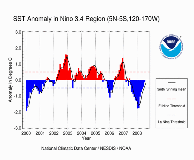
Niño 3.4 region (central equatorial Pacific): The monthly anomaly was -0.18°C (-0.32°F), which was a warming of +0.07°C (+0.13°F) relative to the July SST anomaly. This continues an above-average warming trend in this region for the second consecutive month.
Niño 4 region (western equatorial Pacific): Average SSTs fell slightly to 28.19°C (82.19°F), with a negative anomaly of 0.26°C (0.47°F). This anomaly is a decrease of 0.06°C (0.10°F) from the July anomaly of -0.32°C (-0.58°F).

Please note: On 1 August 2008, the CPC changed their calculations of Niño region SST anomalies to a base period of 1971-2000 from the previous base period of 1961-1990. As a result, all historical anomalies were recalculated. SST anomalies and their comparisons to previous months presented in the above overview as of 7 August, and in monthly summaries beginning with the July summary are based upon this new calculation.
Across much of the central tropical Pacific, trade winds were near average for the month. August Outgoing Longwave Radiation (OLR) and precipitation provided similar indicators, with suppressed OLR over the central Pacific, and generally near-normal precipitation over the eastern Pacific. The basin-wide OLR anomaly was +0.7 W m-2. The August Southern Oscillation Index (SOI) was slightly higher than in July with a value of +0.8 (up 0.6 from July). As a whole, these atmospheric and SST anomalies are consistent with ENSO-neutral conditions. Based upon trends and computer model guidance, the NOAA Climate Prediction Center (CPC) is forecasting the continuation of these neutral conditions through at least the Boreal autumn (Austral spring).
Keywords: ENSO; Niño Regions; Southern Oscillation Index (SOI); Kelvin Waves; Thermocline; Sea Surface Temperatures (SSTs); Madden-Julian Oscillation (MJO); Walker Circulation
Since February 2008, negative sea surface temperature anomalies have weakened over the equatorial Pacific Ocean, and positive anomalies have expanded westward into the east-central equatorial Pacific Ocean. Over the past month, SSTs have continued to be slightly above average over a large portion of the equatorial Pacific Ocean. The ENSO-neutral conditions indicated by the near normal SSTs are also borne out by the above average upper-ocean heat anomalies and normal thermocline slope index. Monthly ENSO indices are all near normal.
The Niño 3.4 Index region (map of Niño regions) SST anomaly was 0.18°C (0.32°F), which was a warming of +0.07°C (+0.13°F) compared with the July index value of -0.11°C (-0.20°F). Likewise, the Niño 4 Index region (western Pacific) SST anomaly warmed +0.06°C (+0.11°F) relative to July to -0.26°C (-0.47°F). For the most recent equatorial Pacific Ocean surface temperatures, please visit NOAA's Tropical Atmosphere Ocean (TAO) project and for weekly or monthly Niño region average SST and anomaly values, visit CPC's Atmospheric and SST Index values page.
With the continued warming of SSTs in the Niño 3.4 index region over the past few months, the 3-month (June-August) running mean was -0.10°C (-0.18°F), which is well within the Oceanic Niño Index (ONI) threshold of -0.5°C (-0.9°F) for neutral conditions (NOTE: For NOAA's official ENSO classification scheme, please see NOAA's El Niño/La Niña Index Definition).
The CPC's most recent ENSO Diagnostic Discussion indicated that ENSO-neutral conditions should persist over the next several months, and while not ruling out a small chance of El Niño development by late this year, the CPC feels that neutral conditions are likely to remain in place through the Boreal Spring (Austral Fall) 2009. The ENSO Wrap-Up from the Australian Bureau of Meteorology (BoM) also reflected the presence and expected continuation of ENSO-Neutral conditions across the tropical Pacific basin through the end of 2008 (see the Australian BoM ENSO Wrap-Up).
August trade winds in the central and western Pacific fluctuated around the long-term mean, although low-level flow in the far western Pacific was stronger than average. Decreased trades continued their presence in the central and eastern equatorial Pacific as indicated by the loop of weekly-averaged zonal winds.
Pacific sea levels measured by the NASA/JPL Jason-1 satellite also reflected ENSO-neutral conditions across the tropical Pacific Ocean in August. Much of the central equatorial Pacific was near normal in August. The tropics west of the Date Line also had near average sea level heights for the month. An area of negative sea level anomalies persisted into August north and south of the equator in the central Pacific, and substantial positive anomalies were present in the far western Pacific region.
In August, OLR values dropped slightly with increased convection over portions of the equatorial Pacific around and east of the Dateline. The map on the left below shows the spatial pattern of global OLR (in W m-2) measured by satellite during August. The lack of convection along the Equator near the Dateline had persisted since the development of the cold event in late May 2007. The suppression of convection in the western Pacific is more clearly seen in the 3-month average OLR anomalies map (below right).
The monthly OLR index for August was +0.7 W m-2 averaged across an area in the western Pacific between 160° E and 160° W. This was the 19th consecutive month that the OLR index had a positive monthly value. However, August's value remains lower than those experienced during the most recent La Niña event. Persistently high positive OLR indices are typical of the mature phase of a La Niña episode, while negative values indicate the presence of increased convection and warm phase conditions.
Note that high frequency variability in OLR is typically associated with the Madden-Julian Oscillation (MJO), which is convective activity that propagates west to east in the near-equatorial region from the Indian Ocean into the Pacific Ocean approximately every 30-60 days. The latest MJO activity can be seen in CPC's graphs of Daily MJO Indices.
The Southern Oscillation Index (SOI) was once again positive in August, increased from July. The standardized monthly averaged value was +0.8, compared to +0.2 in July. These near-normal SOI values generally correspond with ENSO-neutral conditions over the equatorial Pacific. [Consistently positive (negative) values of the SOI are typical of La Niña (El Niño) conditions.]
Since February 2008, negative sea surface temperature anomalies have weakened over the equatorial Pacific Ocean, and positive anomalies have expanded westward into the east-central equatorial Pacific Ocean. Over the past month, SST have continued to be slightly above average over a large portion of the equatorial Pacific Ocean. The ENSO-neutral conditions indicated by the near normal SSTs are also borne out by the above average upper-ocean heat anomalies and normal thermocline slope index. Monthly ENSO indices are all now near normal.
The Niño 3.4 Index region (map of Niño regions) SST anomaly was 0.12°C (0.22°F), which was a warming of +0.44°C (+0.79°F) compared with the negative June index value of -0.32°C (-0.58°F). Likewise, the Niño 4 Index region (western Pacific) SST anomaly warmed +0.23°C (+0.41°F) relative to June to -0.32°C (-0.58°F). For the most recent equatorial Pacific Ocean surface temperatures, please visit NOAA's Tropical Atmosphere Ocean (TAO) project and for weekly or monthly Niño region average SST and anomaly values, visit CPC's Atmospheric and SST Index values page.
With the continued warming of SSTs in the Niño 3.4 index region over the past month, the 3-month (May-July) running mean was -0.26°C (-0.47°F), which is within the Oceanic Niño Index (ONI) threshold of -0.5°C (-0.9°F) for neutral conditions (NOTE: For NOAA's official ENSO classification scheme, please see NOAA's El Niño/La Niña Index Definition).
The CPC's most recent ENSO Diagnostic Discussion indicated that ENSO-neutral conditions should persist over the next several months, and while not ruling out a small chance of El Niño development by late this year, the CPC feels that neutral conditions are likely to remain in place until Boreal Spring (Austral Fall) 2009. The ENSO Wrap-Up from the Australian Bureau of Meteorology (BoM) also reflected the presence and expected continuation of ENSO-Neutral conditions across the tropical Pacific basin through the end of 2008 (see the Australian BoM ENSO Wrap-Up).
July trade winds in the central and western Pacific fluctuated around the long-term mean, although low-level flow in the far western Pacific was stronger than average. Decreased trades continued their presence in the central and eastern equatorial Pacific as indicated by the loop of weekly-averaged zonal winds.
Pacific sea levels measured by the NASA/JPL Jason-1 satellite also reflected the ENSO-neutral conditions present across the tropical Pacific Ocean in July. The region of above average sea levels in the eastern Pacific decreased somewhat between late June and early July, while much of the central equatorial Pacific was near normal in July. The tropics west of the Date Line also had near average sea level heights for the month. An area of negative sea level anomalies persisted into July north and south of the equator in the central Pacific, and substantial positive anomalies were present in the far western Pacific region.
Cloudiness further decreased over the central equatorial Pacific in July, contributing to an increase of OLR values and decreased convection for portions of the equatorial Pacific around and east of the Dateline. This pattern has contributed to the return to normal SST for much of the central Pacific. The map on the left below shows the spatial pattern of global OLR (in W m-2) measured by satellite during July. The lack of convection along the Equator near the Dateline had persisted since the development of the cold event in late May 2007. The suppression of convection in the western Pacific is more clearly seen in the 3-month average OLR anomalies map (below right).
The monthly OLR index for July was +0.9 W m-2 averaged across an area in the western Pacific between 160° E and 160° W. This was the 18th consecutive month that the OLR index had a positive monthly value, and was an increase of 0.5 W m-2 from June. However, July's value remains less than those experienced during the most recent La Niña event. Persistently high positive OLR indices are typical of the mature phase of a La Niña episode, while negative values indicate the presence of increased convection and warm phase conditions.
Note that high frequency variability in OLR is typically associated with the Madden-Julian Oscillation (MJO), which is convective activity that propagates west to east in the near-equatorial region from the Indian Ocean into the Pacific Ocean approximately every 30-60 days. The latest MJO activity can be seen in CPC's graphs of Daily MJO Indices.
The Southern Oscillation Index (SOI) was once again slightly positive in July and decreased slightly from June; however, conditions were near the long-term mean. The standardized monthly averaged value was +0.2, as compared to +0.3 in June. These near-normal SOI values generally correspond with ENSO-neutral conditions over the equatorial Pacific. [Consistently positive (negative) values of the SOI are typical of La Niña (El Niño) conditions.]
Sea surface temperatures (SST) continued to warm across the entire equatorial Pacific Ocean in June, with a remaining pocket of cool La Niña anomalies weakening in the western Pacific. Above normal SSTs persisted along the South American coast, although those anomalies have decreased slightly to values below +1.0°C (+1.8°F). Monthly ENSO indices are all now near normal.
The Niño 3.4 Index region (map of Niño regions) SST anomaly was -0.31°C (-0.56°F), which was a warming of +0.27°C (+0.49°F) compared with the May index value. Likewise, the Niño 4 Index region (western Pacific) SST anomaly warmed +0.19°C (+0.34°F) relative to May to -0.57°C (-1.03°F). For the most recent equatorial Pacific Ocean surface temperatures, please visit NOAA's Tropical Atmosphere Ocean (TAO) project.
With the continued warming of SSTs in the Niño 3.4 index region over the past month, the 3-month (April-June) running mean was -0.50°C (-0.9°F), which is the Oceanic Niño Index (ONI) threshold between a cold event and neutral conditions (NOTE: For NOAA's official ENSO classification scheme, please see NOAA's El Niño/La Niña Index Definition).
The Climate Prediction Center's most recent ENSO Diagnostic Discussion indicated that ENSO-neutral conditions should persist over the next several months. The ENSO Wrap-Up from the Australian Bureau of Meteorology (BoM) also reflected the presence and expected continuation of ENSO-Neutral conditions across the tropical Pacific basin into Austral spring (see the Australian BoM ENSO Wrap-Up).
Trade winds in the central and western Pacific weakened further in June, with speeds varying about the long-term mean throughout the month. Decreased trades continued their presence in the eastern equatorial Pacific as indicated by the loop of weekly-averaged zonal winds.
Pacific sea levels measured by the NASA/JPL Jason-1 satellite also reflected the continued development of ENSO-neutral conditions. A pool of slightly negative sea level anomalies developed in the western equatorial Pacific basin around 165°E by early June. Meanwhile, the region of positive anomalies that developed along the west coast of South America during May persisted into June.
Cloudiness over the central equatorial Pacific was near normal in June, contributing to a continued decrease of OLR values toward normal conditions for portions of the equatorial Pacific near the Dateline. The map on the left below shows the spatial pattern of global OLR (in W m-2) measured by satellite during June. An area of positive OLR anomalies observed in the western equatorial Pacific near the Dateline in May had nearly disappeared in June. The lack of convection along the Equator near the Dateline had persisted since the development of the cold event in late May 2007. The suppression of convection in the western Pacific is more clearly seen in the 3-month average OLR anomalies (below right).
The monthly OLR index for June was +0.4 W m-2 averaged across an area in the western Pacific between 160° E and 160° W. This was the seventeenth consecutive month that the OLR index had a positive monthly value. However, this is the lowest standardized OLR value since May 2007, signifying a return to neutral conditions. Persistently high positive OLR indices are typical of the mature phase of a La Niña episode, while negative values indicate the presence of increased convection and warm phase conditions.
Note that high frequency variability in OLR is typically associated with the Madden-Julian Oscillation (MJO), which is convective activity that propagates west to east in the near-equatorial region from the Indian Ocean into the Pacific Ocean approximately every 30-60 days. The latest MJO activity can be seen in CPC's graphs of Daily MJO Indices.
The Southern Oscillation Index (SOI) was once again slightly positive in June; however, conditions were near the long-term mean. The standardized monthly averaged value was +0.3, as compared to -0.3 in May. SOI values have generally been declining since December, 2007. These near-normal SOI values support the development of ENSO-neutral conditions over the equatorial Pacific. [Consistently positive (negative) values of the SOI are typical of La Niña (El Niño) conditions.]
Sea surface temperatures (SST) continued to warm across the equatorial Pacific Ocean in May, while some areas of the western Pacific still showed some weak cool (negative) SST anomalies left from the La Niña that began the year. Along the South American coast, larger warm (positive) SST anomalies, some exceeding +1.0°C (+1.8°F) were evident. These conditions support a return to ENSO-neutral conditions across the basin over the next few months.
The Niño 3.4 Index region (map of Niño regions) SST anomaly was -0.59°C (-1.06°F), which was a warming of +0.26°C (+0.47°F) compared with the April index value. Likewise, the Niño 4 Index region (western Pacific) SST anomaly warmed +0.20°C (+0.36°F) to -0.77°C (-1.39°F) relative to April. For the most recent global ocean surface temperatures, please see the loop of satellite-derived weekly SST anomalies for May 2008.
Despite the warming of the SSTs in the Niño 3.4 index region over the past month, the 3-month running mean (-0.84°C [-1.5°F]) remained below -0.5°C (-0.9°F) in May, which is the Oceanic Niño Index (ONI) threshold for a cold event (NOTE: For NOAA's official ENSO classification scheme, please see NOAA's El Niño/La Niña Index Definition).
The Climate Prediction Center's most recent ENSO Diagnostic Discussion indicated that the cold event (La Niña) is weakening and will likely become ENSO-neutral in June and July. The ENSO Wrap-Up from the Australian Bureau of Meteorology (BoM) also reflected the significant weakening of cold event conditions across the tropical Pacific basin (see the Australian BoM ENSO Wrap-Up).
Trade winds in the central and western Pacific weakened during May, with speeds varying about the long-term mean near the end of the month. Decreased trades continued their presence in the eastern equatorial Pacific, and showed some westward expansion throughout the month, as shown in the loop of May zonal winds.
Pacific sea levels measured by the NASA/JPL Jason-1 satellite also reflected a weakening of La Niña conditions. The pool of negative sea level anomalies present across the central and eastern equatorial Pacific at the end of April shrunk appreciably through May. Additionally, a sizable region of positive sea level anomalies developed along the South American coast in May.
Cloudiness remained below average over the central equatorial Pacific in May, contributing to above average OLR values for portions of the equatorial Pacific near the Dateline. The map on the left below shows the spatial pattern of global OLR (in W m-2) measured by satellite during May. The area of positive OLR anomalies observed in the western equatorial Pacific primarily west of the Dateline in April continued through May, illustrating the suppressed tropical convection in this region. The lack of convection along the Equator near the Dateline has persisted since the development of the cold event in late May, 2007. The suppression of convection in the western Pacific is more clearly seen in the 3-month average OLR anomalies (below right).
The monthly OLR index for May was +1.2 W m-2 averaged across an area in the western Pacific between 160° E and 160° W. This was the sixteenth consecutive month that the OLR index had a positive monthly value. Persistently high positive OLR indices are typical of the mature phase of a La Niña episode, titlehough the continued decline of the OLR index in May is indicative of the weakening cold phase conditions.
As of early May, NOAA's Climate Prediction Center (CPC) continued to forecast a transition to ENSO-neutral during June-July 2008 (click here for CPC's ENSO Diagnostic Advisory Archive). It is expected that the monthly OLR indices will eventually decrease toward neutral (i.e., near-zero) as the cold event in the equatorial Pacific continues to weaken.
Note that high frequency variability in OLR is typically associated with the Madden-Julian Oscillation (MJO, which is convective activity that propagates west to east in the near-equatorial region from the Indian Ocean into the Pacific Ocean approximately every 30-60 days). The latest MJO activity can be seen in CPC's graphs of Daily MJO Indices.
The Southern Oscilation Index (SOI) was negative for the first time since July, 2007. The standarized monthly averaged value was -0.3, as compared to +0.6 in April. SOI values have been declining since December, 2007. This continued decrease and negative SOI value is further indication of the breakdown of La Niña conditions over the equatorial Pacific. [consistently positive (negative) values of the SOI are typical of La Niña (El Niño) conditions].
Sea surface temperature (SST) anomalies colder than -1.0°C (-1.8°F) remained across the central and western equatorial Pacific this month, but the monthly averaged anomalies decreased in April as the oceanic heat content increased significantly compared with March. Water temperatures in the mixed layer also warmed in April, with an area of positive temperature anomalies in the top 50 meters of the mixed layer in the eastern equatorial Pacific. Warmer-than-average sub-surface temperatures remained in the western equatorial Pacific.
For the month, the SST anomaly in the Niño 3.4 Index region was -0.75°C (-1.35°F) in April, which was a warming of +0.28°C (+0.50°F) compared to the March anomaly. The SSTs in the Niño 4 Index region of the western equatorial Pacific also warmed during April to a monthly anomaly of 0.87°C (1.57°F) below the mean (map of Niño regions). For the most recent global ocean surface temperatures, please see the loop of satellite-derived weekly SST anomalies for April 2008.
Despite the warming of the SSTs in the Niño 3.4 index region over the past month, the 3-month running mean remained below -0.5°C (-0.9°F) in April, which is the Oceanic Niño Index (ONI) threshold for a cold event (NOTE: For NOAA's official ENSO classification scheme, please see NOAA's El Niño/La Niña Index Definition).
The Climate Prediction Center's most recent ENSO Diagnostic Discussion indicated that the cold event (La Niña) is weakening, but will continue to persist over the next several months. The ENSO Wrap-Up from the Australian Bureau of Meteorology (BoM) also reflected the significant weakening of cold event conditions across the tropical Pacific basin (see the Australian BoM ENSO Wrap-Up).
Anomalous easterlies (i.e., Trade winds) were observed across the western equatorial Pacific during April, while in the central equatorial Pacific the trade winds were near-normal, and in the eastern equatorial Pacific they were weaker-than-normal for the month. Significant week-to-week variability in the near-surface winds has been observed along the equatorial region of the Pacific in April, which can be seen in the loop of April zonal winds.
Pacific sea levels measured by the NASA/JPL Jason-1 satellite also reflected a weakening of La Niña conditions, as the sea level anomalies continued to transition to near-normal in the central equatorial Pacific in mid-April. Below-normal sea level anomalies remained north and south of the equatorial zone, reflecting the cooler-than-average ocean temperatures associated with the current La Niña event (see the most recent loop of Pacific basin sea level anomalies).
The map on the left below shows the spatial pattern of global OLR (in W m-2) measured by satellite during April. An area of positive OLR anomalies was observed in the western equatorial Pacific primarily west of the Dateline, illustrating the suppressed tropical convection in this region. The lack of convection along the equator near the Dateline has persisted since the development of the cold event. The suppression of convection in the western Pacific is more clearly seen in the 3-month average OLR anomalies (below right).
The monthly OLR index for April was +1.5 W m-2 averaged across an area in the western Pacific between 160° E and 160° W. This was the fifteenth consecutive month that the OLR index had a positive monthly value. Persistently high positive OLR indices are typical of the mature phase of a La Niña episode, titlehough the decline of the OLR index in April was indicative of the weakening cold phase conditions.
As of early April, NOAA's Climate Prediction Center (CPC) has forecasted the current La Niña episode to transition to neutral during June-July 2008 (click here for CPC's ENSO Diagnostic Advisory Archive). It is expected that the monthly OLR indices will eventually decrease toward neutral (i.e., near-zero) as the cold event in the equatorial Pacific continues to weaken.
Note that high frequency variability in OLR is typically associated with the Madden-Julian Oscillation (MJO, which is convective activity that propagates west to east in the near-equatorial region from the Indian Ocean into the Pacific Ocean approximately every 30-60 days). The latest MJO activity can be seen in CPC's graphs of Daily MJO Indices.
The standardized SOI had a monthly averaged value of +0.6 in April. This was a significant decline compared with the March value of +1.1, and also from the February index value of +2.7, which was the highest SOI of the 2007/2008 La Niña. Overall, April was the ninth consecutive month with a positive SOI value [consistently positive (negative) values of the SOI are typical of La Niña (El Niño) conditions].
Therefore, the decline of the SOI during April indicated the continued weakening of the La Niña across the equatorial Pacific basin.
Sea surface temperature (SST) anomalies colder than -1.5°C (-2.7°F) shifted further to the west during the month, with the coldest anomalies from approximately 160°E to 140°W in March. Water temperatures in the mixed layer warmed in March, with an area of -2.0°C (-5.4°F) and slightly colder temperature anomalies between 50 and 150 meters depth of the mixed layer in the eastern equatorial Pacific. Warmer-than-average temperatures remained in the mixed layer in the western equatorial Pacific, primarily west of the Dateline.
For the month, the SST anomaly in the Niño 3.4 Index region was -1.03°C (-1.85°F) in March, which was an increase of +0.71°C (+1.28°F) compared to the February anomaly. The SSTs in the Niño 4 Index region of the western equatorial Pacific also warmed during March to a monthly anomaly of 0.98°C (1.76°F) below the mean (map of Niño regions). For the most recent global ocean surface temperatures, please see the loop of satellite-derived weekly SST anomalies for March 2008.
Despite the significant warming of the SST anomalies in the Niño 3.4 index region over the past month, the 3-month running mean remained below -0.5°C (-0.9°F) in March, which is the Oceanic Niño Index (ONI) threshold for a cold event (NOTE: For NOAA's official ENSO classification scheme, please see NOAA's El Niño/La Niña Index Definition).
The Climate Prediction Center's most recent ENSO Diagnostic Discussion indicated that the cold event (La Niña) is weakening, but they forecast it to persist over the next several months. The ENSO Wrap-Up from the Australian Bureau of Meteorology (BoM) also reflected the weakening of cold event conditions in the eastern tropical Pacific basin (see the Australian BoM ENSO Wrap-Up).
Anomalous easterlies (i.e., trade winds) were observed across the western equatorial Pacific during March, while in the central equatorial Pacific the trade winds were near-normal, and in the eastern equatorial Pacific they were below-normal for the month. Significant week-to-week variability in the near-surface winds has been observed along the equatorial region of the Pacific over the past month, which can be seen in the loop of March zonal winds.
Pacific sea levels measured by the NASA/JPL Jason-1 satellite also reflected a weakening of La Niña conditions as sea level anomalies had transitioned to close to normal along the equator in the central equatorial Pacific in March. Below-normal sea level anomalies remained north and south of the equatorial zone, reflecting the cooler-than-average ocean temperatures associated with the La Niña event (see the most recent loop of Pacific basin sea level anomalies).
The map on the left below shows the spatial pattern of global OLR (in W m-2) measured by satellite during March. A large region of positive OLR anomalies was observed in the western equatorial Pacific mainly west of the Dateline, illustrating the suppressed tropical convection in this region. The lack of convection along the equator and near the Dateline has persisted since the development of the cold event. The suppression of convection in the western Pacific is also clearly seen in the 3-month average OLR anomalies (below right).
The monthly OLR index for March was +2.4 W m-2 averaged across an area in the western Pacific between 160° E and 160° W. This was the fourteenth consecutive month that the OLR index had a positive monthly value. Persistently high positive OLR indices are typical of the mature phase of a La Niña episode.
As of early March, NOAA's Climate Prediction Center (CPC) has forecasted the current La Niña episode to continue through the Boreal spring (March-May) 2008 (click here for CPC's ENSO Diagnostic Advisory Archive). It is expected that the monthly OLR indices will eventually decrease toward neutral (i.e., zero) as the cold event in the equatorial Pacific begins to weaken over the next several months.
Note that high frequency variability in OLR is typically associated with the Madden-Julian Oscillation (MJO, which is convective activity that propagates west to east in the near-equatorial region from the Indian Ocean into the Pacific Ocean approximately every 30-60 days). The latest MJO activity can be seen in CPC's graphs of Daily MJO Indices.
The standardized SOI had an observed value of +1.1 in March. This was a significant decline compared with the February index value of +2.7, which was the highest monthly SOI of the 2007/2008 La Niña. Overall, March was the eighth consecutive month with a positive index value [consistently positive (negative) values of the SOI are typical of La Niña (El Niño) conditions].
Therefore, the recent decline of the SOI during March indicates the weakening of the La Niña to moderate intensity across the equatorial Pacific basin.
The area of sea surface temperature (SST) anomalies colder than -1.5°C (-2.7°F) continued to shift westward and intensify during the month, with the coldest anomalies from approximately 165°E to 120°W in February. Water temperatures in the mixed layer also decreased in February, with an area of -3.0°C (-5.4°F) and colder temperature anomalies between 50 and 150 meters depth of the mixed layer in the eastern equatorial Pacific. Warmer-than-average temperatures remained in the mixed layer in the western equatorial Pacific this month, primarily west of the Dateline.
For the month, the SST anomaly in the Niño 3.4 Index region was -1.74°C (-3.13°F) in February, which was a slight increase of 0.03°C (0.05°F) compared to the January anomaly. The SSTs in the Niño 4 Index region of the western equatorial Pacific also cooled during February to a monthly anomaly of 1.46°C (2.29°F) below the mean (map of Niño regions). For the most recent global ocean surface temperatures, please see the loop of satellite-derived weekly SST anomalies for February 2008.
Significant cooling of the SST anomalies in the Niño 3.4 index region since the beginning of 2008 has kept the 3-month running mean well below -0.5°C (-0.9°F) in February, which is the Oceanic Niño Index (ONI) threshold for a cold event (NOTE: For NOAA's official ENSO classification scheme, please see NOAA's El Niño/La Niña Index Definition).
The Climate Prediction Center's most recent ENSO Diagnostic Discussion indicated that the cold event (La Niña) had reached maturity by the end of 2007, and the SST anomalies over the past two months have cooled further in the western and central equatorial Pacific. The ENSO Wrap-Up from the Australian Bureau of Meteorology (BoM) also reflects mature cold event conditions in the tropical Pacific basin, which they forecast to persist for several months (see the Australian BoM ENSO Wrap-Up).
Anomalous easterlies (i.e., trade winds) were observed across the western equatorial Pacific during February, while in the central equatorial Pacific the trade winds were near-normal, and in the eastern equatorial Pacific they were below normal for the month. Significant week-to-week variability in the near-surface winds has been observed along the equatorial region of the Pacific over the past month, which can be seen in the loop of February zonal winds.
Pacific sea levels measured by the NASA/JPL Jason-1 satellite were below average across the central equatorial Pacific in February, reflecting the cooler-than-average ocean temperatures and the mature phase of the La Niña event. The positive sea level anomalies have moved slowly westward over the past couple of months (see the most recent loop of Pacific basin sea level anomalies).
The map on the left below shows the spatial pattern of global OLR (in W m-2) measured by satellite during February. A large region of positive OLR anomalies was observed in the western equatorial Pacific centered on the Dateline, illustrating the suppressed tropical convection in this region. The lack of convection along the equator and near the Dateline has persisted for several months, which is clearly seen in the 3-month average OLR anomalies (below right).
The monthly OLR index for February was +2.5 W m-2 averaged across an area in the western Pacific between 160° E and 160° W. This was the thirteenth consecutive month that the OLR index had a positive monthly value. Persistently high positive OLR indices are typical of the mature phase of a La Niña episode.
As of early February, NOAA's Climate Prediction Center (CPC) has forecasted the current La Niña episode to continue through the Boreal spring (March-May) 2008 (click here for CPC's ENSO Diagnostic Advisory Archive). It is expected that the monthly OLR indices will eventually decrease toward neutral (i.e., zero) as the cold event in the equatorial Pacific begins to weaken over the next several months.
Note that high frequency variability in OLR is typically associated with the Madden-Julian Oscillation (MJO, which is convective activity that propagates west to east in the near-equatorial region from the Indian Ocean into the Pacific Ocean approximately every 30-60 days). The latest MJO activity can be seen in CPC's graphs of Daily MJO Indices.
The standardized SOI was +2.7 in February, which was the highest monthly SOI of the 2007/2008 La Niña so far. In fact, the February SOI was the highest index value since January 1974 when it last reached 2.7. Overall, February was the seventh consecutive month with a positive index value [consistently positive (negative) values of the SOI are typical of La Niña (El Niño) conditions].
Therefore, the anomalously high monthly SOI values during the December to February period indicates the persistence of the mature phase of La Niña across the equatorial Pacific basin.
The area of sea surface temperature (SST) anomalies colder than -1.5°C (-2.7°F) moved westward and intensified during the month, with the coldest anomalies from approximately 170°E to 130°W in January. Water temperatures in the mixed layer also decreased in January, with an area of -2.0°C (-3.6°F) and colder temperature anomalies between 50 and 150 meters depth of the mixed layer in the eastern equatorial Pacific. Warmer-than-average temperatures remained in the mixed layer in the western equatorial Pacific this month, primarily west of the Dateline.
For the month, the SST anomaly in the Niño 3.4 Index region was -1.77°C (-3.19°F) in January, which was a decrease of 0.45°C (0.81°F) compared to the December anomaly. The SSTs in the Niño 4 Index region of the western equatorial Pacific also cooled during January to a monthly anomaly of 1.27°C (2.29°F) below the mean (map of Niño regions). For the most recent global ocean surface temperatures, please see the loop of satellite-derived weekly SST anomalies for January 2008.
Significant cooling of the SST anomalies in the Niño 3.4 index region over the past two months kept the 3-month running mean well below -0.5°C (-0.9°F) in January, which is the Oceanic Niño Index (ONI) threshold for a cold event (NOTE: For NOAA's official ENSO classification scheme, please see NOAA's El Niño/La Niña Index Definition).
The Climate Prediction Center's most recent ENSO Diagnostic Discussion indicated that the cold event (La Niña) had reached maturity at the end of 2007, and the SST anomalies have cooled during the month. The ENSO Wrap-Up from the Australian Bureau of Meteorology (BoM) also reflects the maturing of cold event conditions in the tropical Pacific basin, which they forecast to persist for the first few months of 2008 (see the Australian BoM ENSO Wrap-Up).
Anomalous easterlies (i.e., trade winds) were observed across the western equatorial Pacific during January, while in the central and eastern equatorial Pacific the trade winds were near-normal for the month.
Significant week-to-week variability in the near-surface winds has been observed along the equatorial region of the Pacific over the past month, as shown in the loop of January zonal winds. A period of anomalous westerly flow occurred in the eastern Pacific during mid-January, as the easterly trade winds weakened in the equatorial zone.
Pacific sea levels measured by the NASA/JPL Jason-1 satellite were below average across the central equatorial Pacific in January, reflecting the cooler-than-average ocean temperatures and the mature phase of the La Niña event. The positive sea level anomalies have moved slowly westward over the past couple of months (see the most recent loop of Pacific basin sea level anomalies).
The map on the left below shows the spatial pattern of global OLR (in W m-2) measured by satellite during January. A large region of positive OLR anomalies was observed in the western equatorial Pacific near the Dateline, illustrating the suppressed tropical convection in this region. The lack of convection along the equator and near the Dateline has persisted for several months, which is clearly seen in the 3-month average OLR anomalies (below right).
The monthly OLR index for January was +1.0 W m-2 averaged across an area in the western Pacific between 160° E and 160° W. This was the twelfth consecutive month that the OLR index had a positive monthly value. Persistently high positive OLR indices are typical of the mature phase of a La Niña episode.
As of early February, NOAA's Climate Prediction Center (CPC) has forecasted the current La Niña episode to continue through the Boreal spring (March-May) 2008 (click here for CPC's ENSO Diagnostic Advisory Archive). Therefore, it is expected that the monthly OLR indices will eventually decrease toward neutral (i.e., zero), as the cold event in the equatorial Pacific begins to weaken over the next several months.
Note that high frequency variability in OLR is typically associated with the Madden-Julian Oscillation (MJO, which is convective activity that propagates west to east in the near-equatorial region from the Indian Ocean into the Pacific Ocean approximately every 30-60 days). The latest MJO activity can be seen in CPC's graphs of Daily MJO Indices.
The standardized SOI was +1.9 in January, which was the highest monthly SOI of the 2007/2008 La Niña so far. Overall, January was the sixth consecutive month with a positive index value [consistently positive (negative) values of the SOI are typical of La Niña (El Niño) conditions].
Therefore, the persistence of positive monthly SOI values, along with the high monthly SOI values in December and January, indicate that the La Niña has entered its mature phase across the equatorial Pacific basin.
For all climate questions other than questions concerning this report, please contact the National Climatic Data center's Climate Services Division:
Climate Services DivisionFor further information on the historical climate perspective presented in this report, contact:
Karsten Shein-or-
David Levinson


 averaged SST Anomalies")


 averaged SST Anomalies")


 averaged SST Anomalies")


 averaged SST Anomalies")


 averaged SST Anomalies")


