Tracking Global Climate Change: NASA's New Jason-2
"How inappropriate to call this planet Earth, when clearly it is Ocean." - Sir Arthur C. Clarke.
From space, we can get the big picture on global climate change, so there is no doubt that the late great Sir Clarke would be quite impressed with NASA's new next-generation ocean-observing satellite, the Ocean Surface Topography Mission (OSTM/Jason-2). Launched into Earth orbit June 20, 2008, OSTM/Jason-2 is producing information and maps that are already helping scientists to track and understand how and where our oceans are warming, and how our global climate may change.
OSTM/Jason-2 is a collaborative effort between NASA, the National Oceanic and Atmospheric Administration (NOAA), CNES, and the European Organization for the Exploitation of Meteorological Satellites (EUMETSAT).
"It's really a series of missions," explains Jet Propulsion Lab (JPL) Climatologist Dr. William Patzert. "It began in 1992 with the Topex/Poseidon and Jason-1 satellites. We're going into our 16th year of continuous data. More than 2 billion people have seen these images. It has become the way we visualize manmade and natural climate change."
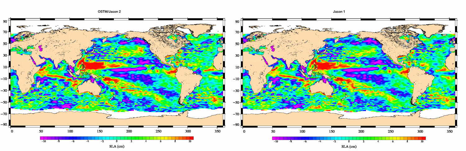
Every ten days, data from precise OSTM/Jason-2 measurements will be used to create a map of the height of the Earth's oceans. Like the land area on Earth, the ocean also has "hills" and "valleys"-- areas where the surface is higher and lower. The precise measurements taken by OSTM/Jason-2, combined with data from a decade and a half of previous altimetry missions, including TOPEX/Poseidon and Jason-1, will help scientists to get a clearer picture of how Earth's oceans circulate, change, and influence our global climate.
With its ability to measure as precisely as 3 centimeters, OSTM/Jason-2 is able to gather more precise data than previous missions such as Topex/Poseidon and Jason-1. "For larger scale ocean currents," says Dr. Lee-Lueng Fu, JPL Project Scientist for OSTM/Jason-2, "we're talking about 1 centimeter, for global sea level change, we talk about a 1 millimeter [accuracy]."
The most accurate maps of ocean surface topography to date, are generated by two main instruments onboard OSTM/Jason-2; the JPL-built Advanced Microwave Radiometer and the CNES-built Poseidon Altimeter. Both instruments bounce a radar signal off the surface of the ocean and record how much time the signal takes to return to the OSTM/Jason-2 satellite. Scientists are then able to make an accurate map -- down to a few centimeters -- of the topography of the ocean surface.
Unique in our Solar System, the Earth has more than 70 percent of its surface covered by warm liquid water. Combined with just the right amount of sunlight, our goldilocks planet is a friendly abode for life. Essentially, a balance of energy between the Sun, the atmosphere, and the oceans controls Earth's climate and keeps the surface temperature of our planet pleasant and constant. But, as NASA data have shown, because of an increase in carbon dioxide and other greenhouse gasses, our atmosphere has been warming, and continues to do so at an accelerating rate. This in turn has caused the Earth's oceans to warm, also at an accelerating rate.
Earth's atmosphere usually reflects the appropriate amount of heat back into space, keeping just enough to maintain the right balance. Earth's vast and deep oceans then act as a giant circulation and storage medium for heat from the Sun. Earth would be a much warmer place if not for our global seas; the upper three meters (10 feet) of ocean water alone, hold as much heat as the entire atmosphere.
For the past 50 years, the oceans have absorbed 85 percent of the heat from global warming.The more heat the ocean holds, the taller the surface of the sea becomes. As sea level rises, storms and hurricanes become more energetic by feeding off the warm water. The warming of the atmosphere and water has caused ice to melt, adding fresh water to the rising salty seas. Humans and other life forms are in danger from rising water.
As JPL Oceanographer Dr. Joshua Willis explains, "Satellites like Jason-2 are our eyes on global climate change. ... If we're not watching the oceans, we're not watching global warming."
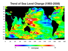
Topex/Poseidon maps show exactly where and how quickly sea level changed between the years 1993 and 2008. According to data from the Topex/Poseidon and Jason-1 satellites, the average sea level has risen about three millimeters (.12 inches) a year since 1993. From 1993 until 2008, melting land ice and warming ocean water have caused the global sea level to rise by an average of 4.5 centimeters (1.7 inches). That may not seem like much, but consider that this took place in just fifteen years. Scientists predict that sea levels will rise even faster as time goes on.
Continuous observations are the key to predicting how our climate may change. The oceans are getting warmer, and ice sheets and glaciers are melting. Jason-2 measures the sum of melting of fresh water ice plus the heating ocean, getting both average height information for Earth, as well as localized hot spots (like El Nino) that have such a large effect on weather.
OSTM/Jason-2 will continue the tradition of data gathering started by Topex/Poseidon and Jason-1, providing even more accurate information and helping to predict changes in climate and how human life will be impacted.
Thanks to Dr. Lee-Lueng Fu, Project Scientist for OSTM/Jason-2, Climatologist Dr. William Patzert, and Oceanographer Dr. Joshua Willis for their help in gathering information for this article.
For more information about OSTM/Jason-2, click here.
Visit JPL's new Global Climate Change Web site: http://climate.jpl.nasa.gov.
Science Features
NASA Science Highlights
Astrobiology Features
Power & Propulsion Features
Astronomy Features
Science & Technology Reports
Technology Features