Support for field operations comes from observing components that are stationary as well as mobile.
More about the Oklahoma Lightning Mapping Array »
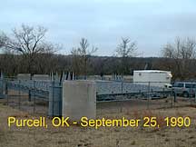
One of central Oklahoma's NOAA Profiler Network sites (larger image)
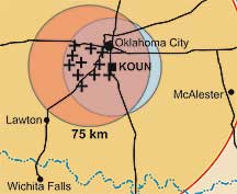
- OKLAHOMA LIGHTNING MAPPING ARRAY for detecting and
measuring all lightning, including flashes that stay within clouds
The Oklahoma Lightning Mapping Array (OKLMA) provides three-dimensional mapping of lightning channel segments over west central Oklahoma and two-dimensional mapping of all lightning over most of Oklahoma. Up to thousands of points can be mapped for an individual lightning flash, to reveal its location and the development of its structure. NSSL scientists hope to learn more about how storms produce intra-cloud and cloud-to-ground flashes and how each type is related to tornadoes and other severe weather. Better lightning mapping techniques show that some supercell thunderstorms have "lightning holes" where updrafts are located and precipitation is scarce. If these holes form, as suspected, just before a storm becomes severe, this information could alert forecasters to developing severe conditions. The OKLMA was an integral part of the 2003 and 2004 Thunderstorm Electrification and Lightning Experiment (TELEX). - WSR-88D radar data provides continuous real-time weather information to researchers in the field.
- Large-scale field programs often make use of "partially" fixed observing components, like Colorado State's CHILL Radar. The multi-parameter 11 cm wavelength radar is transportable and available for use by the research meteorology community. It is a pulsed Doppler weather radar with dual polarization capabilities. Once it is deployed in an optimum location, the radar provides additional data coverage within its range.
- Wind profilers are designed to measure vertical
profiles of horizontal wind speed and direction from near
the surface to above the tropopause. Data from the NOAA
Profiler Network
 are distributed in real-time to operational,
research and private meteorologists.
A profiler site equipped with the RASS
(Radio Acoustic Sounding System)
option also has the capability to measure
and produce vertical temperature profiles.
are distributed in real-time to operational,
research and private meteorologists.
A profiler site equipped with the RASS
(Radio Acoustic Sounding System)
option also has the capability to measure
and produce vertical temperature profiles. - The National Weather Service operates automated upper-air observing
sites throughout the United States, usually taking atmospheric measurements
once every hour. Some states operate mesonets, where localized weather
data that occurs on a smaller scale, or "mesoscale,"
is collected more frequently. Instruments and sensors measure
air temperature, relative humidity, wind speed and direction, barometric
pressure, rainfall, incoming solar radiation, and soil temperatures.
The Oklahoma Mesonet measures
the environment in near real-time at 110 stations across the state.
