 NCDC / Climate Resources / Climate Research / Climate of 1998 / September / Search / Help NCDC / Climate Resources / Climate Research / Climate of 1998 / September / Search / Help
October 14, 1998

|
||||||||||||||||||||||||||||||||||||||||||||||||||||||||||||||||||||||||||||||||||||||||||||||||||||||||||||||||||||||||||||||||||||||||||||||||||||||||||||||||||||||||||||||||||||||||||||||||||||||||||||||||||||||||||||||||||||||||||||


|
SEPTEMBER 1998, WARMEST ON RECORD FOR THE U.S. In keeping with the recent global and national trends, September 1998 was the warmest such month for the U.S. and the entire globe since records began, according to NOAA's National Climatic Data Center. With a national average temperature of 69.1�F, September 1998 surpasses September 1931 (68.4�F) as the warmest such month on record, based upon preliminary data. The 1961-1990 normal temperature for the U.S. during September is 64.8�F. |
 |
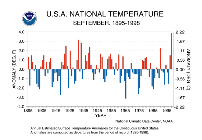
Record warmth for September 1998
with a mean temperature 4.3 deg.F
above the 1961-1990 average
 STATES/REGIONS SET TEMPERATURE RECORDS
- Numerous states and regions set temperature records or were ranked among the top 3 warmest as outlined below:
September Temperature
| Rank | State/Region | Avg.T | Normal | Dep.from Normal | Previous Record | Year |
|---|---|---|---|---|---|---|
| 1 | MT | 61.9 | 54.5 | +7.4 | 61.7 | 1938 |
| 1 | OK | 80.2 | 72.3 | +7.9 | 79.8 | 1931 |
| 1 | WY | 60.1 | 54.3 | +5.8 | 60.0 | 1990 |
| 1 | W.N. Central | 63.7 | 56.8 | +6.9 | 62.7 | 1897 |
| 1 | U.S.A. | 69.1 | 64.8 | +4.3 | 68.4 | 1931 |
| 2 | KS | 74.8 | 67.7 | +7.1 | 76.7 | 1931 |
| 2 | SD | 67.0 | 60.0 | +7.0 | 68.0 | 1897 |
| 3 | ID | 61.3 | 55.6 | +5.7 | 62.2 | 1990 |
| 3 | IA | 68.6 | 62.7 | +5.9 | 70.0 | 1931 |
| 3 | NE | 69.6 | 62.2 | +7.4 | 69.8 | 1931 |
| 3 | NJ | 69.0 | 65.5 | +3.5 | 71.4 | 1961 |
| 3 | NM | 68.1 | 64.3 | +3.8 | 68. | 1997 |
| 3 | ND | 62.6 | 55.7 | +6.9 | 63.4 | 1897 |
| 3 | South | 79.0 | 73.6 | +5.4 | 79.5 | 1911 |
Warmer that the Dust Bowl Era but not as dry
Warmest September on record caps a very warm spring and summer
| The spring and summer of 1998 over the United States has exhibited very warm conditions that are comparable to the dust bowl era of the 1930's. However, the dry conditions which persisted during the 1930's are not evident in nearly the same scale during this past summer or over the last 17 months when global temperature records have been set each month.
The accompanying figures show the areal extent of warm and cold conditions and a temperature index for the 15 month periods July 1997-September 1998, July 1933-September 1934 and July 1935 to September 1936. Note that the recent 15 month period and particulary the spring and summer months of 1998 show the warmth extending over a comparably large area as either of the 15 month periods during the 1930's. During September of 1998, 66.4% of the country was much above normal (in the upper 10 percentile.) By comparison, the warmest period for the 1930's was September, 1933 when 60.8% of the country was categorized as much above normal. Interestingly, in the 1930's there was a cold spell during the winter of 1936 which peaked in February of that year when 54.4% of the country was classifed as much below normal (lower 10 percentile.) No such spell is evident in the 1997-1998 record. |
 July 1997-September 1998 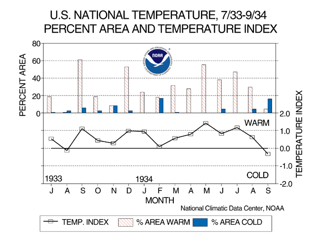 July 1933-September 1934  July 1935-September 1936 |
- The extraordinary warmth of the May-September period of 1998 is depicted in the time series chart below which shows for the U.S. the % of the country with much above normal temperatures since 1895. May to September, 1998 with 58.2% of the country classified as much above normal is the third warmest period in terms of areal extent, exceeded only by the years 1934 (58.6%) and 1936( 65.2%).

larger image
Percent US area with much above normal temperatures, May'97-Sept'98
Spring-Summer 1998: Much Wetter than Comparably Warm 1930's.
- While the warm conditions are similar comparing the two eras the precipitation patterns are markedly different. The areal extent of dry conditions during July 1997-Sept 1998 peaked during May of 1998 with 25% of the country with much below normal precipitation. Otherwise, the nation is characterized by wet rather than dry conditions. Several months during this period showed areal extents of wetness over more than 20% of the country with February, May and June of 1998 being the wettest.
In stark contrast, between July, 1933 and September, 1934 the US was extremely dry with a peak of 45.7% of the country with much below normal precipitation. These dry conditions were partly responsible for the record warm temperatures of that period, because when the soil is wet, energy is used to evaporate water from the soil as opposed to raising the near surface air temperature. So, the dry conditions of 1933-1934 were partly responsible for the record warm temperatures of that period as less energy was used evaporating water from the soil. This makes the extreme warmth of the past two years even more remarkable as this occurred during a period of much wetter soil conditions.
 Percent Area U.S. with much above or much below normal precipitation, Jul'97-Sep'98 |
 Percent Area U.S. with much above or much below normal precipitation, July'33-Sep'34 |
|
YEAR-TO-DATE RANKS AS THE 2ND WARMEST, 7TH WETTEST SINCE 1895 With a national averaged temperature of 57.64�F, preliminary data suggest that the year-to-date, January-September, was the 2nd warmest such period for the United States. The warmest year on record for the year-to-date is 57.72�F recorded in 1934. The coolest such nine-month period occurred in 1912 with an national averaged temperature of 53.30�F. The 1961-1990 normal temperature for the U.S. for the year-to-date is 55.40�F.Preliminary data indicate that the year-to-date, January-September, was the 7th wettest such period since 1895. The 1998 year-to-date national averaged precipitation totaled 25.45 inches. The 1961-1990 normal for the same nine-month period is 22.68 inches. The wettest such nine-month period was 1979 with 25.87 inches while the driest such period was 1934 with 18.78 inches. |
 Jan-Sept State Ranks |
Global Land and Ocean Temperatures Combined Break all time Record
 |
Preliminary data indicate near-surface global land and ocean temperatures for the month of September 1998 established an all-time record high. Temperatures averaged nearly 1.1 deg F above the 1880-1997 long-term mean. The high temperatures were particularly evident over the land as temperatures averaged over 1.6 degrees above the long-term mean, exceeding the old record by one-half of a degree F. The surface temperatures over the ocean were cooler this September than the record last year indicative of the shift from last September's El Niño conditions to this year's La Niña. |

SSM/I Derived Mean Temperature Anomalies September 1998 |
 In situ GHCN and NCEP OI blended SST Analysis - Mean Temperature Anomalies September 1998 |
- The September anomalies show some interesting features. The U.S. by far has the warmest anomalies on the globe, followed by northern China, and the Ukraine. Cooler than normal temperatures and above normal snow covers most of Northern Russia. Most of southern Asia and the Sahel region of Africa also have below normal temperatures, which corresponds with the above normal surface wetness (rainfall) during the month (Easterly waves across the region were more active than normal.)
The ocean surface was cooling down in September, particularly over the east equatorial Pacific and the Gulf of Alaska, where the La Niña is becoming more evident. The warmth is persisting east of the Asian continent and around Australia, which also corresponds to a La Niña signal. The persistent warmth in the north Atlantic, along with the La Niña conditions supported the numerous hurricanes that developed during the month. Generally, the globe as a whole cooled down considerably compared to last month, by about 0.08 deg.C, but still this was enough to break the previous record set just last year.
Comparison to September 1997

larger image
Satellite Derived Mean Temperature Anomalies
September 1997
During September 1997 extremely warm sea surface temperatures existed in the east equatorial Pacific, which correspond with mature El Nino conditions . Likewise, these conditions correspond with below normal temperatures over the western tropical Pacific ocean. The land surface has an undulating wave structure of warm and cold anomalies, which corresponds to the average pattern of the jet stream for the month. During September 1998 there is an inverse structure in the sea surface temperature anomalies, i.e. below normal temperatures over the east equatorial Pacific and above normal temperatures over the western tropical Pacific. This structure corresponds to the developing La Nina conditions. The warmest temperature anomalies in the world exist over the central United States during the month.
Global Temperatures for January to September 1998 were the warmest on record
 Jan-Sept Global Surface Mean Temperature Anomalies |
Near-surface global land and ocean temperatures for the period January through September 1998 established an all-time record high. Temperatures averaged more than 1.25 deg F above the 1880-1997 long-term mean. The high temperatures were particularly evident over the land as temperatures averaged nearly two degrees above the long-term mean, exceeding the old record by over one-half of a degree F. |
 Satellite Derived Jan-Sept 1998 Global Temperature Anomalies |
 In situ GHCN and NCEP OI blended SST Analysis - Mean Temperature Anomalies Jan-Sept 1998 |
- Globally, the summer of 1998 had an average temperature of 62.06 degrees F. This is 1.2 degrees F above the 1880-1997 mean. The warmest all-time temperature for one month for the planet occurred in July, with a temperature of 61.62 degrees F, or 1.22 degrees above the average.
1998 Summer Heat and Precipitation Extremes
- Rapid Shifts in Weather and Climate
- Blistering Heat and Drought
- Flooding from Hurricanes and Tropical Storms

|
|
National
- The climate of the U.S. was characterized by many extreme events during the spring and summer, and some interesting and devastating reversals of conditions (for example from dry to wet) over much of the south and southwest. Florida and much of the southeast began the spring very wet, a signature of the strong El Niño event which led to the proliferation of lush undergrowth.
Then very dry conditions began (May and June) which led to the outbreak of the destructive wildfires in Florida. Drought and intense heat plagued much of Texas during the summer until tropical storm Charley struck southern Texas in late August with flooding rains, resulting in at least 20 deaths in Texas and Mexico. Del Rio Texas recorded its wettest day ever on August 23, with 17.03 inches of rain from Charley's remnants, in amazing contrast to the 2.89 inches of rain received in the previous 8 1/2 months.
Texas State Records / Monthly Mean Temperature-Precipitation Records
Texas State Records |
|
|
Warmest April - July for Texas: 1998: Average 77.65 degrees (Record) 1925: Average 77.65 degrees (tie) |
Driest April - July for Texas: 1998: 4.46 inches (Record) 1956: 6.20 inches |
| Del Rio Precipitation Extremes | |||
| City | Total | Period |
|
| Del Rio | 20.93 inches | Aug 1998 | Wettest Month on Record |
|
|
15.79 inches | Sep 1964 | 2nd Wettest Month on Record |
|
|
13.71 inches | Jun 1935 | 3rd Wettest Month on Record |
| Del Rio | 20.93 inches | Aug 1998 | Wettest August on Record |
|
|
6.10 inches | Aug 1971 | 2nd Wettest August on Record |
| Del Rio | 17.03 inches | Aug 23 1998 | Wettest Day on Record Any Month |
|
|
8.79 inches | Jun 13 1935 | 2nd Wettest Day on Record |
NOAA's National Hydrologic Information Center reported 65 flood-related fatalities for January through August 1998. Fourteen of these occurred in June in the midwest and northeast as a result of heavy rains there. Many states were designated to receive federal disaster assistance during June and July. A number of counties in each state were severely affected by flooding. Examples of the heavy rains include Blue Hill, MA with 17.32 inches in June to set a record for the month, and Marion, IN with 6 inches of rain in 6 hours in early August.
Regional Highlights
West Coast
- Oregon and Washington have received almost no rain since mid-summer, particularly from the Cascades westward. Eugene, Oregon went 83 days, from June 27-September 17th without receiving any rain the longest dry spell on record for that station. Elsewhere, after an exceptionally cool, wet start to summer, the area from the Rockies westward is ending up exceptionally warm.
Midwest
- The most noteworthy extreme event during the summer of 1998, in the Midwest occurred on the 14th of September , when a very large amount of tropical moisture from Tropical Storm Frances met a cold front in the western part of Missouri. Single day rainfall totals of 205 mm (8.08") at the Pleasant Hill WFO, 204 mm (8.05") in Odessa, 196 mm (7.70") in Drexel, and 191 mm (7.50") in Lees Summit made this a spectacular rain event, with a recurrence interval of 50 to 100 years.
South
- Blistering heat enveloped the south during most of the spring and summer with several records set for days with temperatures above 100 deg. F. Del Rio, Texas suffered through a record 69 days with temperatures at or above 100 deg F. Over one dozen cities across the central and southern Plains set new monthly September record high temperatures between the 3rd and 5th of the month, including: Oklahoma City, OK (107 on Sept.3rd); Dallas-Fort Worth, TX (108 on Sept 4th); Scottsbluff, NE (102 on Sept 5th); and Wichita Falls, TX (108 on Sept 5th).
Total Number of Days with Maximum Temperatures 100 Degrees F or Above:
| City | Year | Annual Total | May | June | July | August |
| San Antonio | 1998 | 36 | 1 | 10 | 21 | 4 |
|
|
Previous Years | 33(1948) | 5(1989) | 11(1980) | 20(1980) |
|
| Del Rio | 1998 | 69 | 8 | 22 | 29 | 10 |
|
|
Previous Years | 68(1951) | 9(1953) | 23(1953) | 31(1980) |
|
| Houston | 1998 | 24 | 0 | 2 | 14 | 8 |
|
|
Previous Years | 32(1980) | ||||
| Dallas-Fort Worth | 1998 | 56 | 3 | 8 | 28 | 12 |
|
|
Previous Years | 69(1980) | ||||
|
|
Previous Years | 52(1954) | ||||
| College Station | 1998 | 51 | 11 | 28 | 10 |
|
|
|
Previous Years | 58(1917) |
Hurricane Georges left a trail of destruction in the Caribbean region and across the southern U.S. Gulf coast. Damage estimates are in the 3-4 billion dollar range with over one billion dollars in damages across Puerto Rico alone. Extreme flooding was reported with rainfall amounts in excess of 20 to possibly 30 inches along portions of the southern U.S. Gulf coast. Mobile, Alabama received 13.0 inches of rain from the storm, which boosted the monthly total to 23.0 inches, breaking the September record of 16 inches set 100 years ago. The highest individual storm total reported thus far is Munson, Florida, which reported 25.0 inches of rain from Georges.
Hurricane Bonnie edged into North Carolina's southern coastline near Wilmington on August 26, 1998. Bonnie was the first major hurricane (Category 3) of the 1998 season, and the winds and flooding rains damaged buildings and cut off power to nearly a half-million people. Due to the slow movement of Bonnie, rainfall totals were rather high in parts of eastern North Carolina and extreme southeastern Virginia. Damages are still being tallied, but may exceed $1.0 billion.
High Plains
- Heavy rainfall events, primarily during the third week of August, resulted in some whopping precipitation totals in the northern and eastern portion of the High Plains region. Conversely, the southern and western Plains remained relatively dry. In central North Dakota copious amounts of precipitation, ranging upwards of nine inches in the Bismarck area, were recorded. The heavy rainfall totals extended into eastern South Dakota and Nebraska, where three to six inches of rainfall was common.
Northeast
- The Northeast region of the U.S. set some daily precipitation and temperature extremes during the summer of 1998. Weather patterns were also quite variable going from record cold to record warmth in parts of the region. Bluefield, West Virginia logged a record high temperature of 89 degree F. on Saturday 12th, less than 60 hours after setting a daily-record low temperature of 42 degrees and then continued to record four consecutive daily record highs.
RAPID SWITCH FROM EL NIÑO TO LA NIÑA
El Niño Shifts Toward La Niña During the Spring and Summer
- The remarkably rapid development of the strong El Niño of 97/98 exhibited an equally remarkable reversal during the Northern Hemisphere spring and summer toward La Niña conditions. NOAA's Climate Diagnostics Center monitors the related El Niño Southern Oscillation Index (ENSO) by computing the Multivariate ENSO Index (MEI) where positive values of the MEI representing the warm ENSO phase (El Niño) while negative values represent the cold ENSO phase, (La Niña). The recent drop of the MEI is every bit as unprecedented as was the rapid rise towards El Niño conditions during the Spring of 1997. Further monitoring in the next few months will show whether the MEI will continue its drop towards full-blown La Niña conditions, or whether this extraordinarily rapid transition will finally slow down.
Atlantic Hurricane Season Intensifies
- The shift from El Niño conditions also had a significant effect on the Atlantic hurricane season. While the El Niño suppressed season of 1997 produced only seven named storms, three of which became hurricanes, with one hitting the continental U.S., the 1998 season to date has produced 12 named tropical storms, 8 hurricanes, with 3 hurricanes/tropical storms hitting the U.S., the most since 1989 (see extreme events section for details).

- As data are being received, scientists at The National Oceanic and Atmospheric Administration's National Climatic Data Center are automatically updating The Global Historical Climatology Network data base to maintain a global climate perspective in near real-time.
For more information, refer to ...
SSMI Derived Products
Global Historical Climatology Network (GHCN)
The Global Temperature Anomalies
- NOAA's National Climatic Data Center is the world's largest active archive of weather data. The preliminary temperature and precipitation rankings are available from the center by calling: 828-271-4800 or on the World Wide Web at: http:/www.ncdc.noaa.gov/ol/documentlibrary/cvb.html
Historical precipitation and temperature ranking maps are also available on the Internet at: http://nic.fb4.noaa.gov/products/analysis_monitoring/regional_monitoring/usa.ht ml.
NOAA works closely with the academic and science communities on climate-related research projects to increase the understanding of El Niño and improve forecasting techniques. NOAA's Climate Prediction Center monitors, analyzes and predicts climate events ranging from weeks to seasons for the nation. NOAA also operates the network of data buoys and satellites that provide vital information about the ocean waters, and initiates research projects to improve future climate forecasts. The long lead climate outlooks are available on the Internet at: http://nic.fb4.noaa.gov.
For further information, contact:
NOAA/National Climatic Data Center
151 Patton Avenue
Asheville, NC 28801-5001
fax: 828-271-4328
email: michael.crowe@noaa.gov
Top of Page
NCDC / Climate Resources / Climate Research / Climate of 1998 / September / Search / Help
Downloaded Saturday, 20-Sep-2008 05:33:17 EDT
Last Updated Thursday, 17-Feb-2005 07:21:46 EST by catherine.s.godfrey@noaa.gov
Please see the NCDC Contact Page if you have questions or comments.