Skip Navigation Linkwww.nws.noaa.gov 
NOAA logo - Click to go to the NOAA homepage National Weather Service   NWS logo - Click to go to the NWS homepage
Marine Forecasts


Landlubber's forecast:
"City, St" or zip code


U.S. Offshore Marine Text Forecasts by Zone
(Click on the area of interest)


Atlantic     Gulf, Caribbean and Tropical Atlantic     Pacific


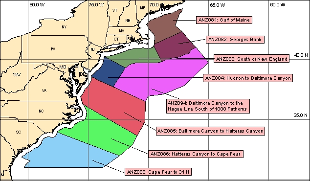
SYNOPSIS associated with New England offshore zones
OFFSHORE MARINE FORECAST which includes the synopsis and all New England offshore zones
SYNOPSIS associated with Mid-Atlantic offshore zones
OFFSHORE MARINE FORECAST which includes the synopsis and all Mid-Atlantic Offshore zones

Cape Fear to 31 N Cape Fear to 31 N Gulf of Maine Gulf of Maine Georges Bank Georges Bank South of New England South of New England Hudson Canyon to Baltimore Canyon Hudson Canyon to Baltimore Canyon Baltimore Canyon to the Hague Line S of 1000 FM Baltimore Canyon to the Hague Line S of 1000 FM Baltimore Canyon to Hatteras Canyon Baltimore Canyon to Hatteras Canyon Hatteras Canyon to Cape Fear Hatteras Canyon to Cape Fear


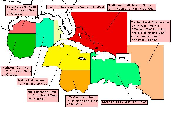
SYNOPSIS associated with for Southwest North Atlantic offshore zones
SYNOPSIS associated with Caribbean Sea offshore zones
OFFSHORE MARINE FORECAST for the SW North Atlantic and Carribean which includes the synopsis and all these zones
SYNOPSIS associated with Gulf of Mexico offshore zones
OFFSHORE MARINE FORECAST for the Gulf of Mexico which includes the synopsis and all zones

Northwest Gulf Northwest Gulf Southwest Gulf Southwest Gulf Middle Gulf Middle Gulf Puerto Rico and Virgin Islands Coastal Forecasts East Gulf East Gulf Northwest Caribbean Northwest Caribbean Southwest Caribbean Southwest Caribbean East Caribbean East of 75W East Caribbean East of 75W Tropical North Atlantic from 7N to 22N between 55W and 65W including waters north and east of the Leeward and Windward Islands Tropical North Atlantic from 7N to 22N between 55W and 65W including waters north and east of the Leeward and Windward Islands Southwest North Atlantic North of 31N and West of 65W Southwest North Atlantic North of 31N and West of 65W

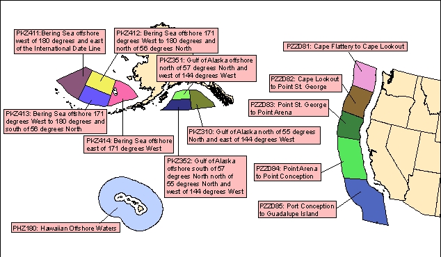
SYNOPSIS associated with California offshore zones
OFFSHORE MARINE FORECAST for California which includes the synopsis and all zones
SYNOPSIS associated with Oregon, Washington offshore zones
OFFSHORE MARINE FORECAST for Oregon, Washington which includes the synopsis and all zones
SYNOPSIS for Eastern Gulf of Alaska
OFFSHORE MARINE FORECAST for Eastern Gulf Of Alaska includes the synopsis
SYNOPSIS for Western Gulf of Alaska
OFFSHORE MARINE FORECAST for Western Gulf Of Alaska includes the synopsis
SYNOPSIS for the Bering Sea
OFFSHORE MARINE FORECAST for the Bering Sea includes the synopsis
SYNOPSIS for Hawaii ofshore zone
OFFSHORE MARINE FORECAST for Hawaii which includes the synopsis

Cape Flattery to Cape Lookout Cape Lookout to Point St. George Point St. George to Point Arena Point Arena to Point Conception Point Conception to Guadalupe Island Gulf of Alaska north of 55 degrees North and east of 144 degrees West Gulf of Alaska offshore north of 57 degrees North and west of 144 degrees West Gulf of Alaska offshore south of 57 degrees North north of 55 degrees North and west of 144 degrees West Bering Sea offshore west of 180 degrees and east of the International Date Line Bering Sea offshore 171 degrees West to 180 degrees and north of 56 degrees North Bering Sea offshore 171 degrees West to 180 degrees and south of 56 degrees North Bering Sea offshore east of 171 degrees West Offshore waters within 240 nm of Honolulu Offshore waters within 240 nm of Honolulu Cape Flattery to Cape Lookout Cape Lookout to Point St. George Point St. George to Point Arena Point Arena to Point Conception Point Conception to Guadalupe Island Gulf of Alaska north of 55 degrees North and east of 144 degrees West Gulf of Alaska offshore north of 57 degrees North and west of 144 degrees West Gulf of Alaska offshore south of 57 degrees North north of 55 degrees North and west of 144 degrees West Bering Sea offshore west of 180 degrees and east of the International Date Line Bering Sea offshore 171 degrees West to 180 degrees and north of 56 degrees North Bering Sea offshore 171 degrees West to 180 degrees and south of 56 degrees North Bering Sea offshore east of 171 degrees West Offshore waters within 240 nm of Honolulu

Offshore marine forecasts are subdivided by zone, each identified by text description and a Universal Generic Code (UGC). These forecasts are prepared by the Ocean Prediction Center (formally the Marine Prediction Center), Tropical Prediction Center, Honolulu Forecast Office and Anchorage Forecast Office. The entire text of these forecasts may be found at NWS Production Schedule for Marine Text Products which also serves as an alternate source of data. This page is also available in a text version.

Similar webpages for Coastal Waters Forecasts by Zone and High Seas Marine Forecasts are also available.

These forecasts are also available via e-mail

NOTICE - Check time and date of forecasts. Linked data may not represent the latest forecast. The Internet is not part of the National Weather Service's operational data stream and should never be relied upon as a means to obtain the latest forecast and warning data. Become familar with and use other means such as NOAA Weather Radio to obtain the latest forecasts and warnings. Please read our DISCLAIMER

This is NOT a complete listing of National Weather Service marine forecast products. See the Marine Product Dissemination Information webpage which contains information on the dissemination of NWS marine weather forecasts including frequency and broadcast schedule information as well as links to products and related information.


National Weather Service
Office of Climate, Weather, and Water Services
Marine and Coastal Weather Services Branch (W/OS21)
Last modified: Jun 11, 2008
Questions, Comments?

Disclaimer
Credits
Glossary
Privacy Policy
About Us
Career Opportunities
`