
Nevada Surface-Water Networks
Surface-water data are collected to develop information about flow and stage that can be used by a variety of diverse water-resources projects and programs.Project Chief:
Cooperators: List of Cooperators
Period of project: Ongoing
Objectives
Data are collected for (1) assessment of water resources, (2) operation of reservoirs and industries, (3) waste disposal and pollution control operations, (4) water-quality estimations, (5) compact and legal requirements, (6) analysis of short-term variability and long-term trends for forecasting, and (7) research.
Approach
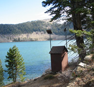
The stage (water level) and discharge of lakes and streams are measured at a network of surface-water stations and sites using standard USGS methods. Data-collection intervals are determined according to the principal purpose of each site.
Data Availability
Data collected as part of the USGS Nevada Water Science Center surface-water network are available from the National Water Information System Web interface (NWISweb). Data are also published in the Annual Data Report (ADR). The ADR is now available online and can be accessed using a text or map interface.
Relevance and Benefits
An important part of the USGS mission is to provide scientific information to manage the water resources of the Nation. To effectively assess the Nation's surface-water resources, the USGS operates more than 7,000 streamgaging stations, monitors lakes and reservoirs, makes periodic flow measurements on rivers and streams using standardized methods, and maintains the data from these stations in a national data base. Data from streamflow stations with data-collection platforms are made available on the World Wide Web (WWW), and are published for each State annually. Much of the data also is available on a near real-time basis to cooperators, customers and the public on the WWW, which is critical for the effective management of the Nation's water resources. Surface-water data are needed to develop information about flow and stage that can be used by a variety of diverse water-resources projects and programs including flood warning; flood assessment; reservoir operations; monitoring water-quality and setting water-quality standards; designing infrastructure such as bridges, culverts, and dams; evaluating the effects of changing land use; detecting long-term changes in climate; and administering compacts, decrees, and (or) treaties on interstate and international bodies of water. The streamgaging stations, and lake and reservoir monitoring stations operated in Nevada are an integral part of the nationwide surface-water data program.
Publications
Contact Information
Kerry Garcia
USGS Nevada Water Science Center
2730 N. Deer Run Rd.
Carson City, NV 89701
Phone: (775) 887-7659
Email:
