|
 |
 |
East Pacific |
 |
 |
Atlantic |
Indian |
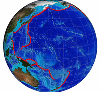
Figure 1. Locations of the unit sources for pre-computed simulated earthquake events in the Propagation Database. These can be combined to provide a very fast forecast during an actual tsunami event.
|
The Propagation Database is a collection of tsunami propagation model runs that have been precomputed for tsunami source functions at selected locations along known and potential earthquake zones.
These pre-computed events can be combined linearly to simulate arbitrary earthquake scenarios to provide a very fast forecast during an actual tsunami event. The accuracy of the Propagation Database has been validated with data from seventeen tsunamis, eight of which were assessed in real-time during events.
The Propagation Database is a key component of the operational tsunami forecasting system (known as SIFT) that the NCTR is developing for deployment at the Pacific and Alaska/west Coast tsunami warning centers. At present, it includes 1160 pre-computed model runs for simulated earthquake sources in the Pacific, Atlantic and Indian oceans (Figure 1).
Pre-Defined Unit Sources
The goal is to define tsunami source functions such that a finite combination of the pre-computed tsunami model runs could closely reproduce the tsunami time series of the actual event. This is feasible because of the linearity of the tsunami generation/ propagation dynamics. Each pre-defined source in the Propagation Database is referred to as a “unit source.” Each unit source is equivalent to a deformation due to an earthquake with a fault length of 100 km, fault width of 50 km, and a slip value of 1 m, equivalent to a moment magnitude of 7.5.
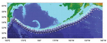 |
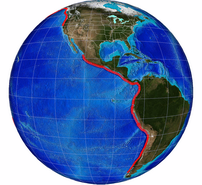
Figure 2. Unit sources along the Aleutian Islands. |
Two rows of unit sources are set up, one for the shallower region and one for the deeper region. Additional rows may be possible depending on the characteristics of the region. These unit sources are located along the known fault zones for the entire Pacific Basin, Caribbean for the Atlantic region and Indian Ocean. Figure 2 shows how the unit sources have been set up for the Aleutian Islands.
Uses of the Propagation Database
Tsunami Propagation: The operational SIFT tsunami forecasting system uses the Propagation Database to compute a quick preliminary forecast of the ocean-wide propagation of the tsunami as a linear combination of unit sources selected to represent the initial earthquake parameters (epicenter and magnitude). This forecast provides interpretation for deep ocean tsunami observations. As more seismic information becomes available, adjustments may be made to the selection of unit sources to better represent the actual seismic event and repeating the linear combination to obtain an improved preliminary forecast. Once the actual tsunami wave reaches the DART®, inversion is performed to adjust the slip distribution of the selected unit sources or add unit sources as needed. The accuracy of this methodology in predicting the actual tsunami propagation is illustrated in Figure 3 for the 15 November 2006 Kuril tsunami event.
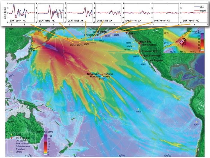 |
Figure 3. Propagation database forecast comparison with data from DART® tsunami buoys for the 15 November 2006 Kuril tsunami
(red line = model, blue line = buoy data). |
Tsunami Inundation: Another use of the Propagation Data base is the use of linear combinations of the pre-computed events in the Propagation Database as input for Stand-by Inundation Models that numerically predict tsunami wave height, current speeds, and inundation extent for a specific coastal area of interest. This capability is also being included in the operational SIFT tsunami forecasting system.
The Propagation Database can be used to forecast offshore tsunami wave heights at any specified location in the Pacific, Atlantic, and Indian oceans. Regional and site-specific first wave and maximum wave height and arrival time can be plotted quickly. It is also possible to plot the offshore wave height distribution for the entire Pacific, Atlantic, and Indian ocean coasts to graphically show the coastal areas that have a higher risk of tsunami threat during an actual event.
Hazard Assessment: The Propagation database can also be used as an initial step for hazard assessment. A combination of unit sources and slip distribution can be selected to generate tsunamis with arbitrary mechanisms and magnitude. An example of the database use for a tsunami hazard assessment study is published in Tang et al. (Figure 4).
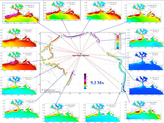 |
| Figure 4. Example of Propagation Database use for tsunami hazard assessment. First arrival and maximum wave amplitude offshore of Pearl Harbor from sources around the Pacific are shown in the middle map. Small dots show location of unit sources with colors indicating amplitude offshore Pearl Harbor from the corresponding source. Large dots are colored according to arrival time from the corresponding source. 14 small maps show maximum computed inundation in the vicinity of Pearl Harbor from selected Mw 9.3 scenarios. |
References:
Gica, E., M. Spillane, V.V. Titov, C. Chamberlin, and J.C. Newman (2008): Development of the forecast propagation database for NOAA's Short-term Inundation Forecast for Tsunamis (SIFT). NOAA Tech. Memo. OAR PMEL-139, 89 pp. [PDF Version]
Tolkova, E. (2007): Compression of MOST Propagation Database. NOAA Tech. Memo. OAR PMEL-134, NTIS: PB2007-108218, 9 pp. [PDF Version
Tang, L., C. Chamberlin, E. Tolkova, M. Spillane, V.V. Titov, E.N. Bernard, and H.O. Mofjeld (2006): Assessment of potential tsunami impact for Pearl Harbor, Hawaii. NOAA Tech. Memo. OAR PMEL-131
Gica, E., Spillane, M.C. and Titov, V.V. (2007): Tsunami Hazard Assessment using Short-Term Inundation Forecasting for Tsunamis (SIFT) Tool. EASTEC International Symposium 2007 - Dynamic Earth: its Origin and Future. September 18-21, 2007, Sendai, Japan. [Invited talk]. [PDF Version]
|