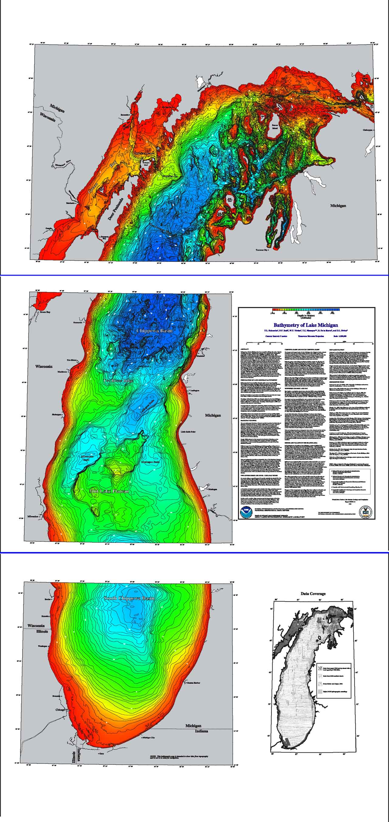
Bathymetry of Lake Michigan
Lake Michigan Bathymetric Poster, Report MGG-11
|
| On-line store: Poster (34x45 inches), Wall-size Poster, CD-ROM | Free Downloads |
Preview Lake Michigan Poster (53K gif) Preview Wall-Size Poster (466K jpg)
The National Geophysical Data Center announces a full color poster measuring 34x45 inches depicting the bathymetric contours of Lake Michigan. Included with the poster are color diffracting glasses for viewing in 3-D. A 1:250,000 scale image of the bathymetry of Lake Michigan is also available as a wall-size (4 by 8 feet in size when fully assembled) poster. The wall-size poster comes in 3 sections. To assemble the full size poster, cut along the lines of latitude on the boundaries of the map pieces that overlap and match the two boundaries together, for example on poster board.
A CD-ROM with images and text that can be accessed with your Web browser is also available. Digital files found on the CD-ROM are as follows -
- vectors of the 5 meter bathymetric contours in an ASCII xyz file and in ARC/INFO® interchange files (5 meter contour intervals and coastal)
- bathymetric grids at 30 and 9 arc-second intervals in ASCII xyz files.
- bathymetric grids at 30, 9, and 3 arc-second intervals in a variety of formats including a GMT/netCDF format
- graphic images in digital format (eps, gif, and jpeg)
Bathymetry of Lake Michigan at a contour interval of 5m (due to the limiting size of the poster only 10 m contours are shown in it) has been compiled utilizing the entire historic sounding data base. Bathymetric contours were scanned and vectorized to geographic coordinates from scale 1:250,000 compilation sheets. This bathymetry resolves physiography of the lake floor to the extent that known features are revealed more accurately, and features never before seen are revealed. For example, the Mackinac Channel, a subaerial river channel which drained Lake Chippewa, can be seen in the northern part of the lake.
PREPARATION OF LAKE MICHIGAN BATHYMETRY
Bathymetry has been compiled using the entire array of good-quality historical hydrographic soundings collected in support of nautical charting over a 120 year period by the NOAA National Ocean Service and its predecessor agency for Great Lakes surveying, the Army Corps of Engineers. Over 600,000 bathymetric soundings were employed, of which approximately 60 per cent were already in digital form. 25 per cent were digitized in conjunction with this effort, and the remaining 15 per cent were available only on paper survey sheets.
Density of tracklines is generally about 2000m for the open lake and ranges from 200m to 600m for nearshore areas. Soundings collected since 1903 were already reduced to the Lake Michigan mean low water datum; these were used for bathymetric contouring without further calibration or adjustments. Soundings collected prior to 1903 were reduced to a mean low water datum. In preparation for bathymetric contouring, digital soundings were converted to metric units and plotted in color; separate colors were assigned to the various ranges. From the paper sheets, contours in metric units were generated directly on overlays; these contours were then reduced to the compilation scale of 1:250,000 and patched in. Compilation sheets were scanned and vectorized; and the resulting digital vector bathymetric contour data were used to generate the imagery shown here. Images were constructed using the publicly-available software Generic Mapping Tools (GMT).
For more information on the Great Lakes Data Rescue Project, see the Great Lakes Data Rescue Project WWW Page.