Local weather and forecast by
"City, St" or zip code |
|
Search
by city or zip code. Press enter or select the go button to submit request
|
Meteorological Comparison of Hurricanes
Audrey and Rita
Compiled by:
Donovan Landreneau, Forecaster
Sam Shamburger, Forecaster
Comparing Hurricane Audrey to
Hurricane Rita
June 27, 1957 to September
23-24, 2005
|
Minimum Sea Level Pressure |
|
Location |
Hurricane Audrey |
Hurricane Rita |
| inches of mercury |
millibars |
inches of mercury |
millibars |
| Alexandria, LA |
29.00" |
982.1 mb |
29.28" |
991.5 mb |
| Baton Rouge, LA |
29.54" |
1000.3 mb |
29.46" |
997.6 mb |
| Cameron, LA |
*28.32" |
*959 mb |
*<28.06" |
*<950 mb |
| Galveston, TX |
29.13" |
986.5 mb |
**29.37" |
**994.6 mb |
| Lafayette, LA |
29.34" |
993.6 mb |
29.30" |
992.2 mb |
| Lake Charles, LA |
28.69" |
971.4 mb |
28.59" |
968.2 mb |
| Lufkin, TX |
29.34" |
993.6 mb |
**29.27" |
**991.2 mb |
| Monroe, LA |
29.07" |
984.4 mb |
29.47" |
998.0 mb |
| New Orleans, LA |
29.65" |
1004.2 mb |
29.60" |
1002.4 mb |
Port Arthur, TX
(SE TX Regional) |
28.69" |
970.9 mb |
28.12" |
952.3 mb |
| Shreveport, LA |
29.28" |
991.3 mb |
29.05" |
983.8 mb |
|
*
estimated/unofficial
** last data recorded before equipment failure |
|
Maximum Sustained Winds & Wind Gusts |
|
Location |
Data Source |
Hurricane Audrey |
Hurricane Rita |
Maximum Sustained Wind
(1-minute avg.) |
Peak Wind Gust |
Maximum Sustained Wind
(2-minute avg.) |
Peak Wind Gust |
|
Alexandria, LA |
NWS |
48 mph |
64 mph |
50 mph |
62 mph |
| Baton
Rouge, LA |
NWS |
40 mph |
69 mph |
41 mph |
53 mph |
| Cameron,
LA |
NOAA |
unknown |
unknown |
**77 mph |
**112 mph |
| Galveston,
TX |
NWS |
58 mph |
76 mph |
**45 mph |
**62 mph |
| Lafayette,
LA |
NWS |
58 mph |
86 mph |
51 mph |
59 mph |
| Lake
Charles, LA |
NWS |
75 mph |
97 mph |
76 mph |
96 mph |
| Lufkin, TX |
NWS |
20 mph |
32 mph |
**33 mph |
**50 mph |
| Monroe, LA |
NWS |
35 mph |
63 mph |
31 mph |
43 mph |
| New
Orleans, LA |
NWS |
35 mph |
53 mph |
35 mph |
48 mph |
| Orange, TX |
FCMP |
unknown |
*100 mph |
75 mph |
98 mph |
Port
Arthur, TX
(SE TX Regional) |
NWS |
72 mph |
85 mph |
81 mph |
105 mph |
|
Shreveport, LA |
NWS |
30 mph |
51 mph |
40 mph |
53 mph |
|
*
estimated/unofficial
** last data recorded before equipment failure |
|
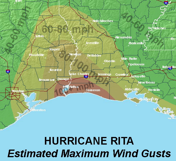
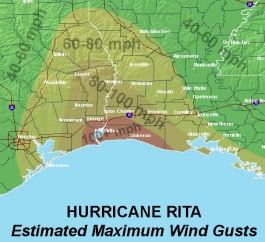
Estimated Maximum
Wind Gust maps |
|
Hurricane Audrey |
Hurricane Rita |
|
 |
 |
|
Storm Surge |
|
Location |
Hurricane Audrey |
Hurricane Rita |
| MSL |
NGVD88 |
| Calcasieu Pass, LA |
12.1 ft |
*6.7 ft |
| Cameron, LA |
10.6 ft |
16.2 ft |
| Cypremort Point, LA |
10.2 ft |
12.1 ft |
| Grand Chenier, LA |
13.9 ft |
14.5 ft |
| Hackberry, LA |
6.7 ft |
8.0 ft |
| Intracoastal City, LA |
8.1 ft |
11.0 ft |
| Johnsons Bayou, LA |
10.4 ft |
12.4 ft |
| Lake Charles, LA |
7.0 ft |
8.4 ft |
| Morgan City, LA |
8.5 ft |
6.1 ft |
| Oak Grove, LA |
12.4 ft |
13.4 ft |
| Pecan Island, LA |
10.9 ft |
10.4 ft |
| Sabine Pass, TX |
9.4 ft |
9.8 ft |
|
* last data recorded before equipment failure |
|
Rainfall |
|
Location |
Data Source |
Hurricane Audrey |
Hurricane Rita |
| Alexandria Power Plant, LA |
NWS COOP |
3.70" |
*7.60" |
| Baton Rouge, LA |
NWS |
1.51" |
9.30" |
| Galveston, TX |
NWS |
1.85" |
* |
| Lafayette, LA |
NWS |
3.69" |
6.24" |
| Lake Charles, LA |
NWS |
7.57" |
7.68" |
| Lufkin, TX |
NWS |
0.27" |
5.51" |
| Monroe, LA |
NWS |
2.85" |
3.50" |
| New Orleans, LA |
NWS |
0.15" |
2.07" |
| Port Arthur, TX |
NWS |
6.90" |
8.89" |
| Shreveport, LA |
NWS |
0.45" |
5.54" |
| Monroe, LA |
NWS |
2.85" |
3.50" |
|
* official data unavailable due to equipment failure |
|
| Page last modified: October 5, 2007 |
|
|