

 NCDC / Climate Monitoring / Hurricanes / Help NCDC / Climate Monitoring / Hurricanes / Help

|
| The official hurricane season in the Atlantic runs from 1 June to 30 November, however hurricanes can and do occasionally form outside this season as well. The most active month, statistically, is September. The 2005 season had the most named storms of any season on record and reflects a longer period of higher activity in the Atlantic. |
|
As can be seen in the graph to the right, Atlantic hurricane activity appears to have phases. Since around 1995 the Atlantic has been more active than the long-term mean, and storms have been more intense than average. However, within these multidecadal phases (another active phase was from around 1945-1970), certain years will be influenced by factors such as El Niño or La Niña. Typically for the Atlantic this translates to fewer hurricanes in El Niño years and more in La Niña years. There is still uncertainty as to whether global warming has affected hurricane frequency or intensity for a variety of reasons. The strong decadal variations may be masking a global warming component, and uncertainty with respect to data quality and sources preclude any definitive long-term estimate of change. |
 larger image |
|
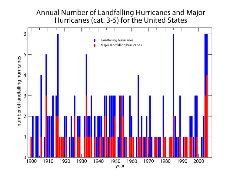
In the graphs below, the number of U.S. landfalling hurricanes and major hurricanes is shown for each year (left graph) and each decade (right graph). While an active season in the Atlantic need not necessarily translate into more storms impacting the U.S. coast, the more active recent decade (1996-2005) also shows an increase in landfalling storms compared to the previous four decades. |
 larger image |
 larger image |
|
|
| The Saffir-Simpson scale (shown in the table below) is the measure of a hurricane's intensity and defines tropical systems with windspeeds of 39 mph (a minimal tropical storm) to over 155 mph (a major category 5 hurricane). These categories help to forecast potential damage associated with a landfalling tropical cyclone. |
|
Generally speaking, a minimal tropical storm will cause only light damage and will pick up only light unsecured items. There is seldom significant damage to buildings. A category one hurricane can cause damage to trees and bushes and unsecured mobile homes. Usually, stable structures are not significantly affected. A storm surge of 4-5 ft can be expected with a category one storm and some coastal road flooding is possible. At the other extreme, a category five storm (such as Hurricane Andrew in 1992, or Hurricane Mitch in 1998) will destroy all mobile homes and blow down all trees and shrubs. Many substantial, secure buildings will have total roof failure and extensive window and door damage. Storm surge can be anticipated at around 18 ft with a category five storm. |
 Useful Links
|
Questions?| For all climate questions other than questions concerning this report, please contact the National Climatic Data Center's Climate Services Division: |
|
Climate Services Division NOAA/National Climatic Data Center 151 Patton Avenue Asheville, NC 28801-5001 fax: 828-271-4876 phone: 828-271-4800 email: questions@ncdc.noaa.gov |
|
For further information on the historical climate perspective presented in this report, contact: |
|
David Levinson NOAA/National Climatic Data Center 151 Patton Avenue Asheville, NC 28801-5001 fax: 828-271-4328 email: David.Levinson@noaa.gov |
NCDC / Climate Monitoring / Climate of 2004 / hurricanes / Search / Help