Skip Navigation Links weather.gov 
NOAA logo-Select to go to the NOAA homepage NDBC Title GraphicClick to go to NDBC home page   Select to go to the NWS homepage
Home News Organization


    Station List

 Observations
    Observations via
      Google Maps

    Recent
    Historical
    Obs Search
    Ship Obs Report
    NOAA Obs
    APEX
    DART®
    MMS ADCP
    TAO
    DODS
    HF Radar
    OSMC
    Dial-A-Buoy
    RSS Feeds Image indicating link to RSS feed access page
    Email Access

 Station Status
    NDBC Maintenance
    NDBC Platforms
    Partner Platforms

 Program Info
    About NDBC
     Met/Ocean
          Moored Buoy
          C-MAN
    TAO
    DART®
    VOS
    CSP
    IOOS® DAC

 Publications
    Hurricane Data Plots
    Mariners Weather
      Log

    Observing
      Handbook No. 1


 Science Education

 FAQ
 Contact Us
 Links
 
NOAA is celebrating 200 years of science, service, and stewardship. Visit the NOAA 200th celebration Web site to learn more.
USA.gov is the U.S. government's official web portal to all federal, state and local government web resources and services.

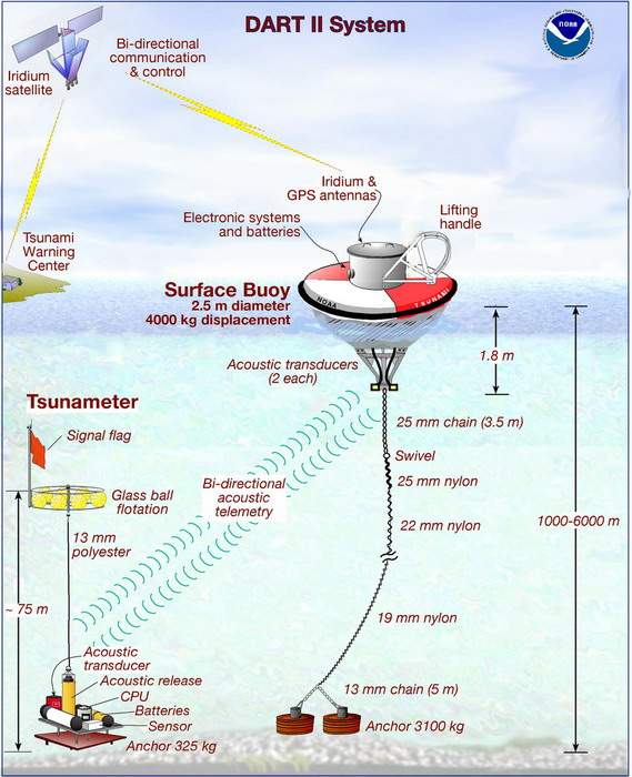
Notice: NDBC plans to conduct testing of its DART (tsunameter) network the week of January 12-16, 2009. Click here for details.

DART® Design Characterstics/Specifications

SUMMARY OF DART II PERFORMANCE CHARACTERISTICS/SPECIFICATIONS

Mandatory Characteristic
Measurement sensitivity
Sampling interval, internal record
Sampling interval, event reports
Sampling interval, tidal reports
Two-way end-to-end communications
Tsunami data report trigger
Data flow, BPR to TWC
Specification
Less than 1 millimeter in 6000 meters; 2 * 10-7
15 seconds
15 and 60 seconds
15 minutes
On demand, tsunami warning center (TWC) trigger
Automatically by tsunami detection algorithm
Less than 3 minutes after triggered event
Desired Characteristic
Reliability and data return ratio
Maximum deployment depth
Minimum deployment duration
Operating Conditions
Theoretical Battery Life, buoy
Theoretical Battery Life, tsunameter
Maximum status report interval
Specification
Greater than 80%
6000 meters
1 year
Beaufort 9
Greater than 2 years
Greater than 4 years
Less than 6 hours

DART Mooring System

Iridium uses a Motorola 9522 L-band trans- ceiver from NAL Research at 2400 baud.

GPS is a Leadtek model 9546 receiver

Buoy:
--- Fiberglass over foam.
--- Computer is 32-bit, 3.3 volt Motorola 68332
--- System electronics use 2560 watt-hour D-cell battery pack.

Mooring is 19 mm 8-strandplaited nylon line with rated breaking strength of 7100 kg.

Acoustic modems on tsunameter and buoy:
--- Benthos ATM-880 Telesonar with AT-421LF directional transducer.
--- Powered by 1800 watt-hour batteries.

Tsunameter:
--- Pressure sensor is a 0-10000 psi model 410K Digiquartz Paroscientific unit.
--- Tilt sensor is Geometrics 900-45 to determine orientation.
--- Uses Alkaline D-cell battery with 1560 watt-hour capacity.
--- Uses same computer as buoy.
U.S. Dept. of Commerce
National Oceanic and Atmospheric Administration
National Weather Service
National Data Buoy Center
    1007 Balch Blvd.
    Stennis Space Center, MS 39529
Feedback
Page last modified: April 1, 2008
Disclaimer
Credits
Glossary
Privacy Policy
About Us
Career Opportunities