 NCDC / Climate Monitoring / Climate of 2004 / July / Global / Search / Help NCDC / Climate Monitoring / Climate of 2004 / July / Global / Search / Help

|
Climate of 2004 - July in Historical Perspective National Climatic Data Center
16 August 2004
|

|
Global Analysis / Global Hazards / United States / U.S. Drought / Extremes
Use these links to
access detailed analyses of Global and U.S. data.
Global Highlights:
- Based on preliminary data for July 2004, global average combined land and sea surface temperature was sixth warmest on record
- July temperatures were above average throughout Alaska, the western half of North America and Scandinavia, with below average temperatures in the Great Plains of the U.S. and adjoining parts of Canada as well as the United Kingdom
- Precipitation during July was above average across the Great Plains of the U.S., the majority of Europe and much of South America, with drier than average conditions in Alaska, India and Japan
- Near-neutral SSTs across the central equatorial Pacific basin prompted forecasts of a developing El Niño.
|
|
Contents of this Section:
|

|
The data presented in this report are preliminary. Ranks and anomalies may change as more complete data are received and processed. The most current data may be accessed via the Global Surface Temperature Anomalies page.
|
 Introduction Introduction
The two maps below utilize different base periods and may reflect different anomaly values of land surface temperatures. The dot map on the left uses anomalies that were calculated from the Global Historical Climatology Network (GHCN) data set of land surface stations using a 1961-1990 base period. The map on the right is a blended product which uses satellite and surface anomaly values of measured land and ocean temperatures as well as SSTs with the base period of 1988-2004. Both maps reflect conditions during July 2004, indicating above average temperatures in Alaska, the majority of Canada, the eastern half of Russia and Saudi Arabia, with cooler than average temperatures in the Great Plains of the US, parts of southern Australia, Mali and southern Brazil.
The mean position of upper level ridges of high pressure and troughs of low pressure (depicted by positive and negative 500 millibar height anomalies on the July 2004 map) are generally reflected by areas of positive and negative temperature anomalies at the surface, respectively. For other Global products see the Climate Monitoring Global Products page.
|
Temperature Rankings and Graphics
Current Month / Year-to-date
|
July |
Anomaly |
Rank |
Warmest Year on Record |
Global
Land
Ocean
Land and Ocean
|
+0.46°C (+0.83°F)
+0.38°C (+0.68°F)
+0.40°C (+0.72°F)
|
7th warmest
4th warmest
6th warmest
|
1998 (+0.98°C/1.76°F)
1998 (+0.52°C/0.94°F)
1998 (+0.66°C/1.19°F)
|
Northern Hemisphere
Land
Ocean
Land and Ocean
|
+0.49°C (+0.88°F)
+0.53°C (+0.95°F)
+0.51°C (+0.92°F)
|
10th warmest
2nd warmest
5th warmest
|
2002 (+0.93°C/1.67°F)
1998 (+0.57°C/1.03°F)
1998 (+0.70°C/1.26°F)
|
Southern Hemisphere
Land
Ocean
Land and Ocean
|
+0.36°C (+0.65°F)
+0.28°C (+0.50°F)
+0.29°C (+0.52°F)
|
17th warmest
10th warmest
11th warmest |
1998 (+1.15°C/2.07°F)
1998 (+0.50°C/1.00°F)
1998 (+0.62°C/1.12°F)
|
|
|
January-July |
Anomaly |
Rank |
Warmest Year on Record |
Global
Land
Ocean
Land and Ocean |
+0.85°C (+1.53°F)
+0.38°C (+0.68°F)
+0.52°C (+0.94°F)
|
3rd warmest
4th warmest
4th warmest |
2002 (+1.15°C/2.07°F)
1998 (+0.51°C/0.92°F)
1998 (+0.70°C/1.26°F)
|
Northern Hemisphere
Land
Ocean
Land and Ocean
|
+0.93°C (+1.67°F)
+0.44°C (+0.80°F)
+0.64°C (+1.15°F)
|
4th warmest
2nd warmest
3rd warmest
|
2002 (+1.29°C/2.32°F)
1998 (+0.52°C/0.94°F)
1998 (+0.77°C/1.39°F)
|
Southern Hemisphere
Land
Ocean
Land and Ocean
|
+0.49°C (+0.88°F)
+0.35°C (+0.63°F)
+0.38°C (+0.68°F)
|
8th warmest
7th warmest
6th warmest
|
1998 (+0.89°C/1.60°F)
1998 (+0.52°C/0.94°F)
1998 (+0.59°C/1.06°F)
|
|
The most current data may be accessed via the Global Surface Temperature Anomalies page.
Precipitation
The maps below represent anomaly values based on the GHCN data set of land surface stations using a base period of 1961-1990. The map to the left is precipitation anomalies measured in millimeters, the map to the right is the percentage of average (1961-1990) precipitation. During July 2004, much above average precipitation fell across the northeastern U.S., southeastern Asia, eastern Europe and Argentina. Below average precipitation was observed in the eastern half of Australia, India, Norway and Mongolia.
|
The satellite images below were acquired from SSM/I satellite data using a base period of 1988-2004. The map on the left reflects surface liquid wetness conditions, while the map on the right reflects snow cover conditions for the month. Snow covered areas that are normally snow-free during this month will appear drier than average on the wetness image since a wetness value cannot be determined for regions that are snow covered. Data in these areas that are normally snow covered are displayed as missing. This is due to the snow crystalline structure which produces a considerable amount of scatter and makes it difficult for the SSM/I to accurately detect the surface conditions. The SSM/I products are experimental and are under continuing review and development. Additional data and information can be found on the SSM/I Browser.
|
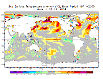
Images of sea surface temperature conditions are available for all months to date during 2004
at the weekly SST page
Troposphere
The table below summarizes mid-tropospheric conditions for July 2004. These temperatures are for the atmospheric layer centered in the mid-troposphere (approximately 2-6 miles above the Earth's surface) which also includes a portion of the lower stratosphere. (The MSU channel used to measure mid-tropospheric temperatures receives about 25 percent of its signal above 6 miles.) Analysis of the satellite record that began in 1979 indicates that global temperatures are increasing in the mid-troposphere, but the magnitude of the trend differs based on the analysis methods used in adjusting for factors such as orbital decay and inter-satellite differences. The 1979-2004 trend for July is 0.05°C/decade based on data from the University of Alabama at Huntsville (UAH). Based on data provided by Remote Sensing Systems (RSS) the trend for July is 0.12°C/decade. The base period used in both data sets is 1979-1998.
|
|
July |
Anomaly |
Rank |
Warmest Year on Record |
| UAH mid-troposphere
|
-0.17°C (-0.31°F)
|
6th coolest
|
1998 (+0.47°C/0.85°F)
|
| RSS mid-troposphere
|
+0.04°C (+0.07°F)
|
13th warmest |
1998 (+0.54°C/0.97°F)
|
|
|


