Global Analysis / Global Hazards / United States / U.S.
Drought / Extremes
Use these links to access detailed analyses of Global and U.S. data.


Hurricane Katrina (Imagery courtesy: CIMSS/SSEC)
|
Global Hazards And Significant Events
August 2005
In the United States, powerful Hurricane Katrina slammed into southeastern Louisiana and Mississippi on the 29th, producing widespread devastation along the central U.S. Gulf Coast. Katrina will likely become the most costly natural disaster in U.S. history. Additional information can be found below.
|
Drought & Heat | Flooding | Storms | Tropical Cyclones | Extratropical Cyclones | Severe Winter Weather

Across the United States, moderate to severe drought persisted throughout parts of the Pacific Northwest eastward into the northern Rockies. Meanwhile, severe to extreme drought expanded across the Mississippi Valley region during August, where some of the worst conditions were observed in Illinois. |

U.S. Drought Monitor
|

African Rainfall Anomalies
|
Long-term drought
continued in parts of the Greater Horn and southern Africa, including southern Somalia southward into central and southern Mozambique, southern Malawi and eastern Zimbabwe. For the
latest African analysis and forecast, see the Famine Early Warning System Network.
|
A multi-month drought continued into August in much of western Europe. Since the beginning of October 2004, rainfall has been less than half of normal in areas of the United Kingdom, France, Spain and Portugal. Dry conditions also aggravated wildfires in the region, and nearly 3,000 firefighters battled blazes in Portugal during late August (AFP). |

Western Europe Drought
|


Bulgaria Flooding
|
Flooding affected parts of Bulgaria for the second time in the last two months. A State of Disaster declaration was issued for 22 municipalities in 7 districts located in the western part of the country (OCHA). There were 12,000 people evacuated from their homes in early August, along with a total of 20 fatalities since the flooding began in June 2005 (AFP/OCHA/DPA). |
Heavy rainfall affected other areas of central and eastern Europe during August, with flooding reported in sections of neighboring Romania, Hungary and Macedonia. The hardest-hit area of Europe was Romania, where 31 flood-related fatalities were reported. Farther to the west, flooding also affected areas of Germany, Austria and Switzerland. At least one death was reported in Germany, with four in Austria and also in Switzerland. Preliminary damage was estimated at over $1 billion (USD) in both Switzerland and Romania (Reuters/AFP). |
In Sudan, flooding in early August affected the Darfur and Khartoum states, displacing thousands of people and resulting in at least 8 deaths. Rainfall in Elfashir, North Darfur state on August 3, 2005 totaled 133 mm (5.24 inches), a new daily record since 1918 (IFRC). |

Sudan Flooding
|
In neighboring Ethiopia, 7,500 people in the northeastern part of the country were forced out of their homes as the Awash River rose above the flood stage. At least 5,000 hectares (~12,400 acres) of agricultural land were submerged (DPA).
In the Central African Republic (CAR), heavy rain caused the collapse of 3,000 houses and left up to 20,000 people homeless in the capital city of Bangui during early August. The rainy season in the CAR typically begins in mid-July (AFP).
In northeastern Iran, flooding in the Golestan province killed at least 43 people during August 9-10, 2005 (AFP/BBC News).
Flooding and landslides in China were blamed for the deaths of 32 people in the central province of Hubei during late August (Reuters).
Across northern Thailand, heavy rains produced severe flooding in the latter half of August. More than 4,500 villagers' homes were inundated due to flooding along the Ping River. There were at least 11 fatalities (IFRC).
For flooding information related to Hurricane Katrina, please see the Tropical Cyclone section of this report, the special Hurricane Katrina summary page or the 2005 Atlantic Hurricanes page.
|


August 12, 2005 Storm Reports
|
In the United States, severe thunderstorms produced a tornado that affected the town of Wright, Wyoming on the afternoon of August 12. The tornado destroyed or damaged more than 80 homes at a mobile home park, rendering 85 families homeless. There were two fatalities (Associated Press). |
In Canada, severe thunderstorms produced at least two tornadoes in an area just outside of Guelph, Ontario on the 19th. Cars were overturned and trees downed, although no injuries were reported (Reuters).
In Peru, heavy rains and strong winds were tentatively blamed on a Peruvian passenger plane crash on the 23rd. There were at least 37 deaths and 40 injuries aboard the TANS Boeing 737. Preliminary indications suggested that wind shear, which is the abrupt change in wind speed or direction with height, prompted the emergency landing near Pucallpa (Associated Press/BBC News/CNN).
|


Satellite Image Of Matsa
|
Typhoon Matsa originated in the northwest Pacific Ocean on July 31 and reached typhoon strength by August 2. Matsa reached the coast of China's Zhejiang province (near Huangyan) early on the 6th with maximum sustained winds near 140 km/hr (75 knots or 85 mph). The typhoon forced the evacuation of 1.24 million people along the coast, and there were 13 deaths reported (Associated Press/Reuters). |
Tropical Storm Harvey developed as a depression on the 2nd, and became the earliest-forming eighth storm in the Atlantic on the 3rd. (In those years that have had eight-named storms, the average date of occurrence is September 29). Harvey passed about 50 km (30 miles) south of Bermuda early on the 4th, with heavy rainfall on the island and winds gusting to tropical-storm force. |

Satellite Image Of Harvey
|

Satellite Image Of Sanvu
|
Typhoon Sanvu developed as a depression in the Philippine Sea before reaching typhoon intensity by the 13th as it trekked across the South China Sea. Sanvu made landfall near Shantou in China's Guangdong province on the 13th with maximum sustained winds near 120 km/hr (65 knots or 75 mph). There were two deaths attributed to the typhoon (Reuters). |
Tropical Storm Jose formed in the Bay of Campeche on the 22nd, reaching the coast of Mexico about 95 km (60 miles) northwest of Veracruz around midnight local time on the 23rd. Maximum sustained winds were near 85 km/hr (45 knots or 50 mph) at the time of landfall. Jose's primary impact was heavy rainfall. |

Satellite Image Of Jose
|

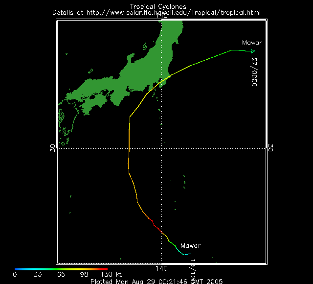
Satellite Image Of Mawar
|
Typhoon Mawar developed in the northwest Pacific Ocean on the 19th, attaining typhoon status by the 21st. Mawar passed just south of Tokyo, Japan on the 25th with maximum sustained winds near 165 km/hr (90 knots or 105 mph). Very heavy rain fell along storm's path across coastal Japan.
|
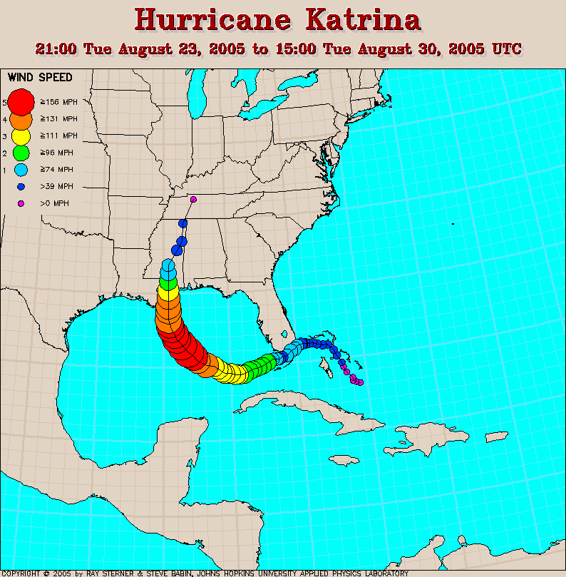
Hurricane Katrina formed in the southeastern Bahamas as a depression on the 23rd, reaching tropical storm status the next day. Katrina became a hurricane just before landfall in south Florida between Hallandale Beach and North Miami Beach on the evening of the 25th. Maximum sustained winds at the time of landfall were near 130 km/hr (70 knots or 80 mph). There were 11 fatalities in South Florida, including 4 by falling trees. More than 1.3 million customers lost electrical services, and preliminary insured loss estimates ranged from $600 million to $2 billion (USD) in the state of Florida (Associated Press).
|

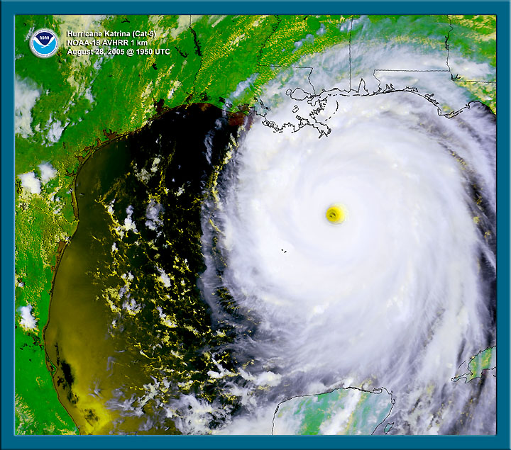
Satellite Image Of Katrina
|

Radar animation of Katrina (~6MB)
|
Katrina emerged in the Gulf of Mexico during the morning of the 26th and moved west-southwest into open waters of the Gulf while re-strengthening. By the 28th, Katrina reached category-five intensity on the Saffir-Simpson scale.
Katrina's minimum central pressure was observed by reconnaissance aircraft on the afternoon of the 28th at 902 millibars (26.64 inches of mercury), the fourth lowest pressure ever recorded from a hurricane in the Atlantic Basin. The top three include Hurricane Gilbert in 1988 (888 millibars), the Labor Day Hurricane of 1935 (892 millibars), and Hurricane Allen in 1980 (899 millibars). Katrina made landfall in Plaquemines Parish in southeastern Louisiana early on the 29th with maximum sustained winds near 205 km/hr (110 knots or 125 mph), a strong category-three, and the third most-intense landfalling hurricane in U.S. history (according to a minimum landfall pressure of 920 millibars or 27.17 inches of mercury). |
The center of the hurricane passed just east of New Orleans, where winds gusted over 155 km/hr (85 knots or 100 mph). Widespread devastation and unprecedented flooding occurred, submerging at least 80 percent of the city as levees failed. Farther east, powerful winds and a devastating storm surge of 6.1 to 10 meters (20-30+ feet) raked the Mississippi coastline, including Gulfport and Biloxi, where Gulf of Mexico floodwaters spread several kilometers (miles) inland. Rainfall amounts of 10-20 cm (8-10 inches) were common along and to the east of the storm's path. Katrina weakened to a tropical storm as it tracked northward through Mississippi and gradually lost its identity as it moved into the Tennessee Valley on the 30th, dumping heavy rainfall along its course. |

Satellite Image Of Katrina
|

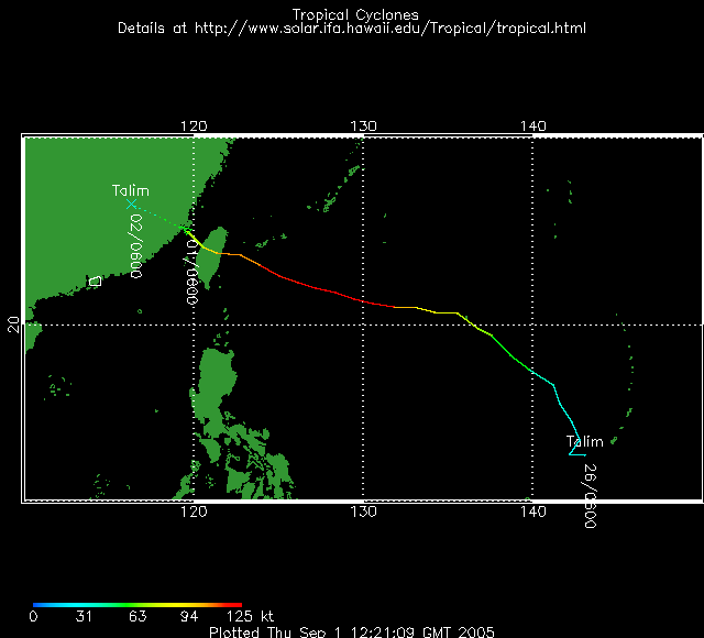
Satellite Image Of Talim
|
Typhoon Talim developed on the 25th in the western Pacific Ocean, reaching typhoon strength by the 29th. Talim made landfall in Taiwan late on the 31st with maximum sustained winds near 195 km/hr (105 knots or 120 mph). The typhoon shut down businesses, schools and financial markets and caused 1.48 million power outages. There were 2 deaths and 39 injuries in Taiwan (Reuters/The China Post). |

In Uruguay, a powerful storm system on the 23rd-24th produced strong winds in excess of 160 km/hr (100 mph) in the departments of Canelones, Montevideo, San Jose, Colonia and Maldonado, where nearly 70 percent of the country's population live. Thousands of homes were damaged and around 20,000 people lost electricity and telephone service. Montevideo's international airport was temporarily shut down late on the 23rd due to the high winds and heavy rainfall. There were seven people killed and dozens injured (Associated Press/OCHA). |

Uruguay Storm
|
In Australia, a strong storm system brought heavy rains and strong gusty winds at the end of August. Heavy rains brought flooding to the Meander, Macquarie and South Esk Rivers, plus strong winds exceeding 100 km/hr (60 mph) across south and east sections of the state. Winds gusted as high as 120 km/hr (75 mph) atop Mount Wellingon (elevation 1,271 meters or 4,170 feet) (ABC).
|


Australian Temperatures On August 10
|
Across southern Australia, snow fell in parts of Victoria, New South Wales and Tasmania on August 10, 2005. It was the first snowfall to sea level in Victoria since July 1986, and the heaviest and most widespread snowfall event since July 19-20, 1951. Numerous records for daily maximum temperatures were also set around the region, as high temperatures struggled to reach between 5 and 8°C (41 and 46°F) in many areas (ABC/BBC News/Australian Bureau of Meteorology. |
For all climate questions other than questions concerning this report,
please contact the National Climatic Data Center's Climate Services
Division:
- Climate Services Division
NOAA/National Climatic Data Center
151 Patton Avenue, Room 120
Asheville, NC 28801-5001
fax: 828-271-4876
phone: 828-271-4800
email: ncdc.orders@noaa.gov
|
For further information on the historical climate perspective presented in this report, contact:
- Scott Stephens
NOAA/National Climatic Data Center
151 Patton Avenue
Asheville, NC 28801-5001
fax: 828-271-4328
email: Scott.Stephens@noaa.gov
|
|


