|
 Global Analysis / Global Hazards / United States / U.S.
Drought / Extremes
Global Analysis / Global Hazards / United States / U.S.
Drought / Extremes
Use these links to access detailed analyses of Global and U.S. data.

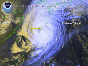
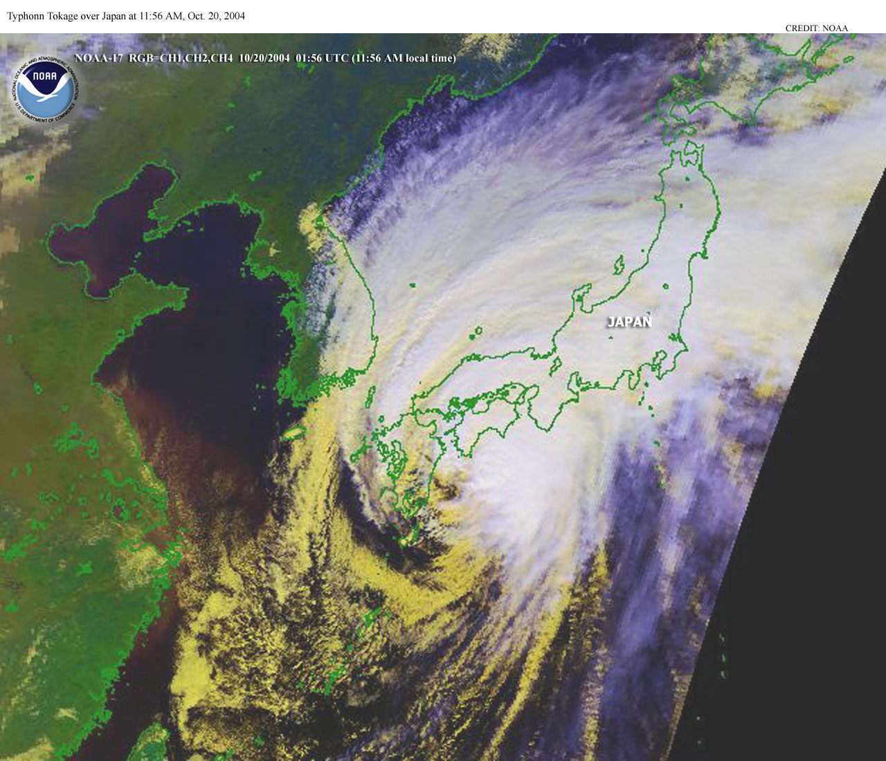
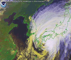 Typhoon Tokage Over Japan Typhoon Tokage Over Japan
|
Global Hazards And Significant Events
October 2004
Typhoon Tokage was the tenth typhoon to strike Japan this year, which is a new record for the number of landfalling typhoons in a single season for the country. Additional information can be found below.
|
 Drought & Heat | Flooding | Storms | Tropical Cyclones | Extratropical Cyclones | Severe Winter Weather

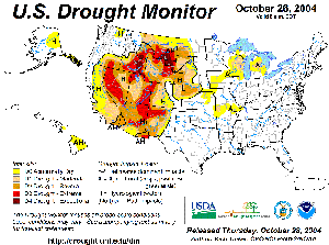
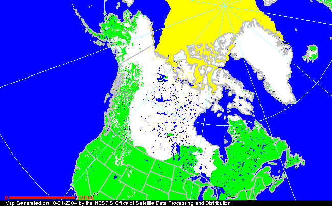
| In the United States, severe to exceptional long-term drought continued throughout much of the Intermountain West, with the worst-affected areas in parts of eastern Idaho, northeastern Wyoming and adjacent areas of Montana. In Nebraska, the Platte River near Columbus was dry at the beginning of the month. |
Larger Image
|
For comprehensive drought analysis, please see the current U.S. drought report.
 Larger Image Larger Image
|
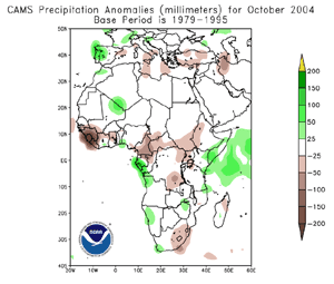
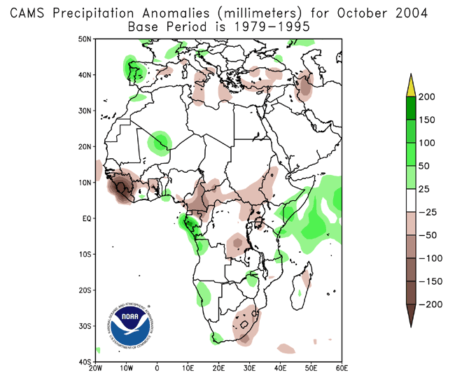
Significant rains fell in early October in the Sool Plateau of northern Somalia. However, four years of long-term drought continued to have devastating effects. In southeastern Kenya, two-year rainfall has been near half of normal. For the latest African analysis and forecast, see the Famine Early Warning System Network.
|


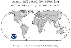
| In South Asia, heavy rains during October 8-10 brought major flooding to India's northeastern state of Assam, neighboring areas of Bangladesh and Nepal. Flash flooding and mudslides claimed 133 lives in Assam and West Bengal states in India, 39 in Bangladesh and 5 in Nepal (Associated Press). Thousands of livestock were also lost to the flooding. |
 Larger Image Larger Image
|
For an archive of flood events worldwide, see the Dartmouth Flood Observatory.

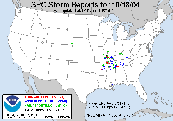
| Severe thunderstorms erupted in the U.S. Tennessee Valley region on the 18th, resulting in 28 reports of tornadoes in Arkansas, Missouri, Tennessee and Alabama. There were three fatalities in southeastern Missouri near the town of Cooter, while at least 118 buildings were damaged and 15 people injured in Arkansas from the storms (Associated Press). |
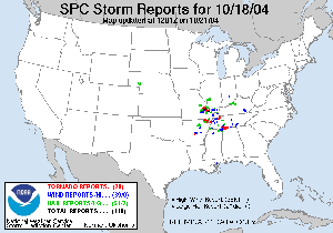 Larger Image Larger Image
|

| Typhoon Ma-on developed in the western Pacific Ocean on the 4th, reaching typhoon intensity by the 6th. Ma-on made landfall along the east coast of Japan on the 9th, with maximum sustained winds near 165 km/hr (90 knots or 105 mph). This was the strongest typhoon to strike this part of Japan and the greater Tokyo area in 10 years, and the ninth typhoon to affect Japan this season. There were six fatalities (Reuters).
|
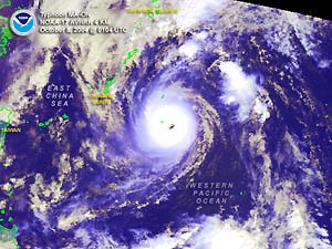 Larger Image Larger Image
|
 Larger Image Larger Image
|
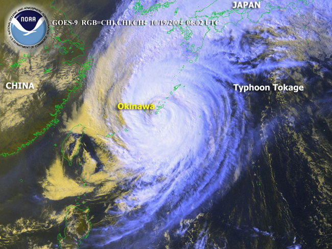
Typhoon Tokage developed in the western Pacific Ocean on the 12th, passing through the Northern Mariana Islands and reaching typhoon strength by the 13th. Tokage reached Okinawa on the 19th with maximum sustained winds near 150 km/hr (80 knots or 90 mph), and crossed directly over Japan during the 19th-21st. The typhoon's large diameter (over 480 km or 300 miles) brought strong winds and heavy rainfall to nearly all of the Japanese islands, producing significant flooding and wind damage. Tokage also produced a record eight-story high wave (24 meters or 80 feet) off the port of Muroto on the southern island of Shikoku on the 20th. This was the highest wave recorded in the country since the Ministry of Land, Infrastructure and Transport started monitoring wave heights in 1970 (AFP). There were 79 fatalities from Tokage, making it the deadliest typhoon for Japan since October 1979 when 115 people were killed or presumed dead (AFP). Tokage is the tenth typhoon this year to hit Japan, which is a new record for the most typhoons in a single season. The old record was 6 set in 1990. Records began in 1951 (Reuters/Associated Press). |
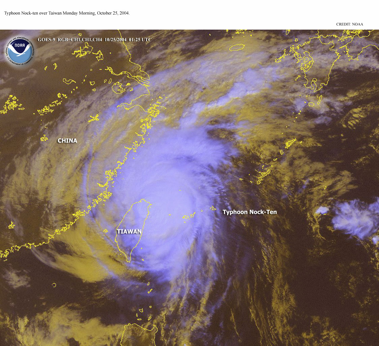
| Typhoon Nock-ten developed in the western Pacific Ocean on the 16th, reaching typhoon intensity by the 18th. Nock-ten skirted the northeast coast of Taiwan on the 25th with maximum sustained winds near 205 km/hr (110 knots or 125 mph). There were four deaths attributed to flooding, with at least 100 injuries, mostly caused by flying debris (AFP). The typhoon weakened and dissipated as it moved over the East China Sea.
|
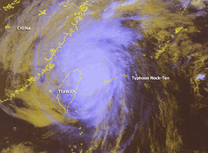 Larger Image Larger Image
|
A table containing the Accumulated Cyclone Energy (ACE) index for global tropical cyclones occurring during the month of October 2004 is available.

 Larger Image Larger Image
|
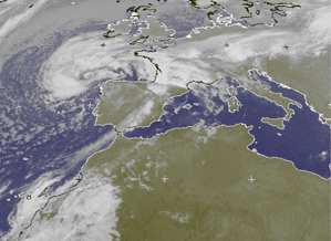
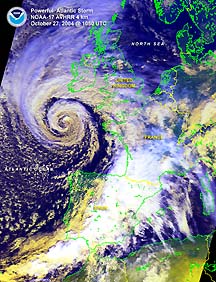
A powerful storm system affected portions of western Europe during October 8-9, 2004. In Portugal, power was disrupted for many residents in central and northern parts of the country as winds gusted over 100 km/hr (60 mph). The winds damaged at least 40 percent of the 300 hectares (740 acres) of greenhouses that exist in central Portugal. There was one reported fatality that was attributed to the strong winds (AFP). |
| Another strong storm system affected the United Kingdom around October 27 with strong winds and heavy rainfall. Across Ireland, winds gusted over 110 km/hr (70 mph) and heavy rainfall produced flooding. The River Lee reached the highest level since 1962, producing significant flooding in the southwestern city of Cork (Associated Press). |
 Larger Image Larger Image
|

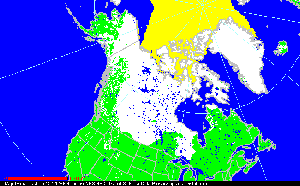
| Snow fell across much of the Canadian grain-belt during mid-October, effectively ending the growing season in many parts of the prairie provinces. As much as 18 cm (7 inches) of snow covered fields in northern Alberta, with 15 cm (6 inches) at Saskatoon, Saskatchewan during the 17th-18th (Reuters).
|
 Larger Image Larger Image
|
References:
Basist, A., N.C. Grody, T.C. Peterson and C.N. Williams, 1998: Using the Special Sensor Microwave/Imager to Monitor Land Surface Temperatures, Wetness, and Snow Cover. Journal of Applied Meteorology, 37, 888-911.
Peterson, Thomas C. and Russell S. Vose, 1997: An overview of the Global Historical Climatology Network temperature data base. Bulletin of the American Meteorological Society, 78, 2837-2849.
For all climate questions other than questions concerning this report, please contact the National Climatic Data Center's Climate Services Division:
For further information on the historical climate perspective presented in this report, contact:
Scott Stephens
NOAA/National Climatic Data Center
151 Patton Avenue
Asheville, NC 28801-5001
fax: 828-271-4328
email: Scott.Stephens@noaa.gov
 NCDC / Climate
Monitoring / Climate
of 2004 / Hazards / Search / Help NCDC / Climate
Monitoring / Climate
of 2004 / Hazards / Search / Help
http://www.ncdc.noaa.gov/oa/climate/research/2004/oct/hazards.html
Downloaded Tuesday, 16-Sep-2008 10:14:25 EDT
Last Updated Tuesday, 29-Nov-2005 14:05:14 EST by Scott.Stephens@noaa.gov
Please see the NCDC Contact Page if you have questions or comments.
|


