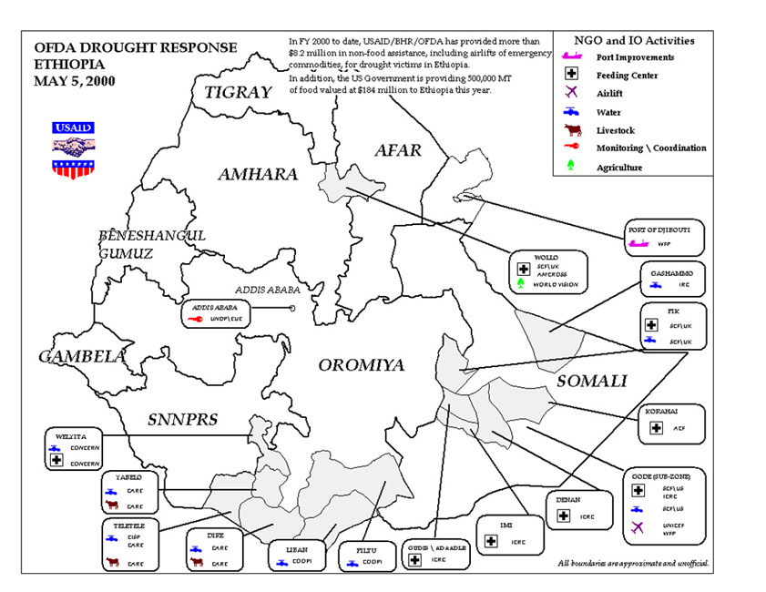
Drought in Ethiopia
Currently, the Government of the Federal Democratic Republic of Ethiopia (GFDRE) estimates that 8 million people are affected by the drought, primarily in the southern and southeastern portions of the country. Due to the recent failure of the secondary harvest, or belg season, this number may increase to as many as 10 million people to include northern drought-affected regions (the highlands) of the country. Additional details are available on the U.S. Agency for International Development page.
Weather Log - May 1-10th, 2000
Africa is not the only area dealing with drought conditions. Drought continues to worsen across portions of southern Asia. Drought has severely hit parts of Pakistan and Afghanistan. The drought has also affected some three million people in Sindh and Baluchistan provinces in western and central India. See the ten day forecast for temperature and precipitation and soil moisture.
Midwest Flooding: Floods assocated with torrential rains from heavy thunderstorms affected eastern Oklahoma in the U.S., on the 6th where six to ten inches of rain fell with one death reported. The same system spawned additional drenching rains across parts of western Missouri. The flash floods in Missouri washed out roads, inundated homes and killed at least two people early Sunday (7th) after more than a foot of rain swamped east-central Missouri. A special news report is available here. Also, see the Midwest Regional Climate Center's report on the flooding and resulting damages.
Weather Log - May 10-20th, 2000
New Mexico Fires: Firefighters struggle to hold the line against fires whipped by furious winds that raced through 400 homes, and the entire cities of Los Alamos and White Rock, New Mexico were evacuated. Winds, which are hampering firefighter efforts, are not expected to subside until the weekend (13th-14th). See the NOAA 15 satellite image depicting the smoke plume on Thursday evening, May 11th 2000. Some of the fires have been contained as of Monday the 15th. The fire has burned more than 42,000 acres and forced the evacuation of about 25,000 residents, but there have been no reports of deaths or serious injuries. President Bill Clinton on Saturday declared 12 counties affected by the blaze eligible for disaster relief. About 260 homes are thought to have been lost in the fire, and overall damage is estimated to be as much as $1 billion by some sources. A news report is available here .
Tornadoes and severe thunderstorms rumbled through the Midwest and the Great Lakes region around the 11-13th. Various National Weather Services Offices have issued special reports. See the following for reports from Kansas City and Chicago. Also, see the Midwest Regional Climate Center's report on the storms.
Flooding associated with powerful storms lashed southeastern Argentina and parts of Uruguay on the 16th. Three children died and nine people were injured when a tree fell on an emergency shelter in Rosario, 290 kilometers (180 miles) northwest of the capital Buenos Aires. A 28-year-old man was electrocuted when he stepped on a fallen power line in southern Buenos Aires. A complete news report is available here.
Storm chasers in Nebraska got within 1/4 mile of a tornado on the 17th--the compete CNN news story with video is available here. The same storm system brought some heavy snows to parts of the mountains of Wyoming and Colorado, closing roads and passes.
Heavy rains fell in southeast Texas on the 20th--the heavest rains were centered in the counties around the Houston area. The greatest rains occurred around Liberty with over 19 inches of rain reported. Twenty four hour state record rainfall maps and tables are available here. The 24-hour state record for Texas is 43.00 inches which fell at Alvin on July 25-26th, 1979.
Weather Log - May 21-31, 2000
According to news reports, an estimated 130 million people - 15 percent of the population - in more than 70,000 villages and 230 urban centres are at risk due to the extreme drought in parts of India. Apart from economic loss due to low agricultural production, loss of animal wealth, inadequate nutrition and primary health care, the impact of the drought is likely to retard the development process. The most severely of the 11 affected States are Gujarat, Rajasthan, and Andhra Pradesh. Daily high temperatures have been running in the 40-44 C (104-111 F ) range.
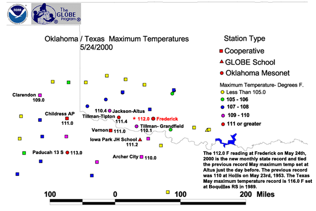
Altus, Oklahoma (Mesonet site) reached 112 degrees on Tuesday May 23rd. This set a new all-time May maximum temperature extreme for the state of Oklahoma. The previous record was 110 degrees recorded at Hollis on May 23rd, 1953. Frederick, Oklahoma tied the 112 degree record the following day on May 24th, 2000, and is now the state record for May. A detailed map using NCDC cooperative station and NWS stations, Oklahoma Mesonet, and GLOBE schools is available here
On May 24th, 2000 the temperature reached 110 degrees F at Carlsbad, NM. This tied the state record maximum temperature for May previously set at Rincon in May of 1896.
New National Temperature Record for May: On the 29th, the high temperature reached 122 degrees F in Death Valley, California. This reading not only broke the May state record of 121 degrees set in Blythe, California in 1910 and earlier years, but also set a new national record maximum temperature for the month of May. A complete list of monthly state records is available at the NCDC Temperature Extremes Page
The B-15 Iceberg (May 18th image) off the Ross Ice Shelf has already split into two. General movement is to the right (westerly) and appears to have moved about 100 - 150 km since the April 15 image .
Drought and Wildfires in Southern U.S.: The deep south from Texas eastward across much of Louisiana, Mississippi, Alabama, Georgia, Florida, and South Carolina continues to experience drought conditions. The drought is especially severe across southeast LA, southern MS and AL, much of GA, the FL panhandle, and western SC. Wildfires continue to burn across parts of central and south Florida as dryness and warm temperatures provide the right environment for additional fires to start. The Florida Division of Forestry reports that approximately 3,198 fires have burned 104,755.4 acres (statewide) from January 1, 2000 through May 29, 2000. Currently (as of the 31st) more than 135 wildfires are burning. For an updated wildfire report click here.
Other global highlights for the month can be found at NOAA/OGP Special Global Summary for May 2000.
Note: Hazard event satellite images available courtesy of NOAA OSEI Satellite Images WWW site.
 NCDC / Climate Research / Climate of 2000 / May / Climate-Watch / Search / Help


