
 Introduction Introduction
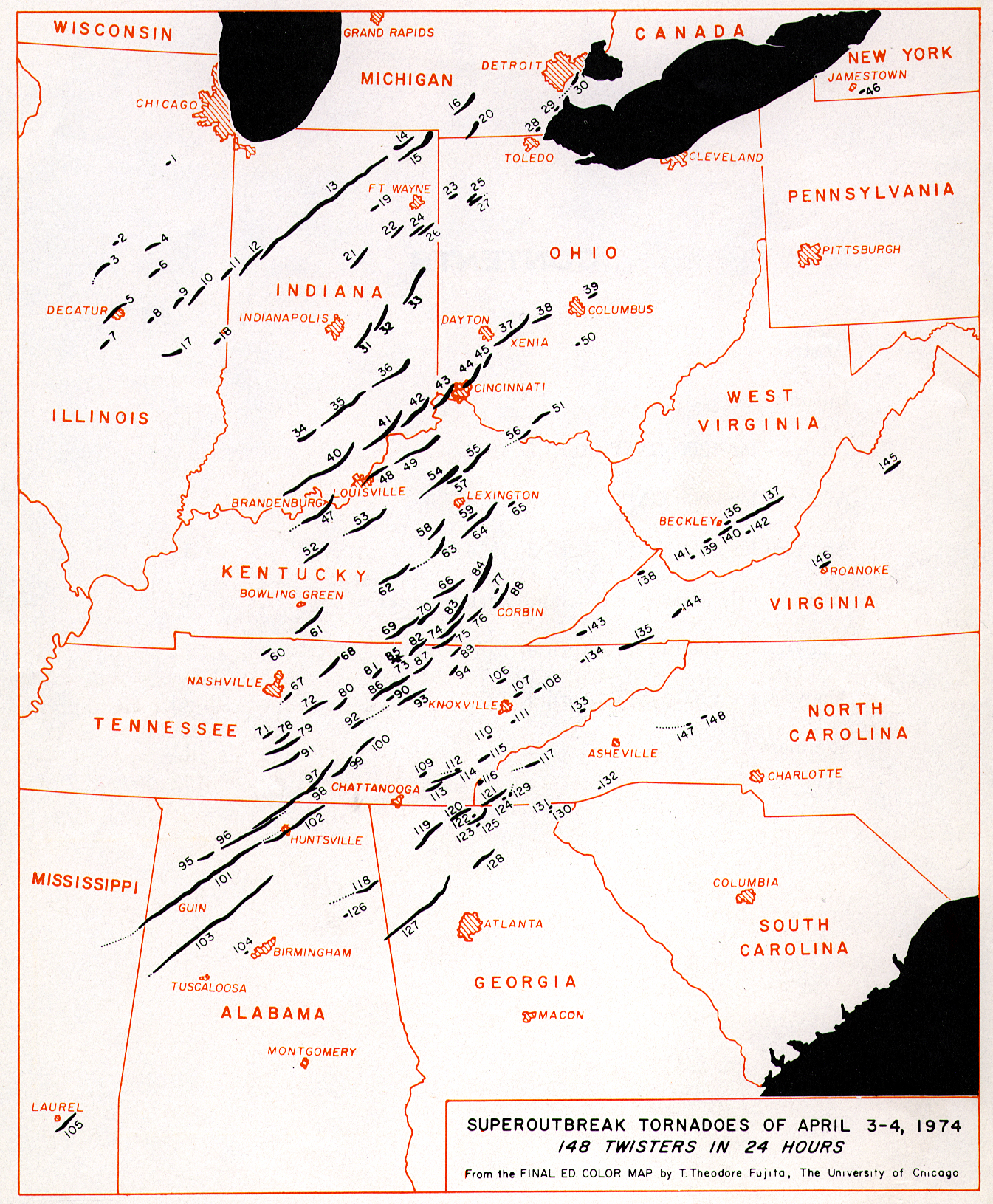
This month is the 25th anniversary of the famous "Xenia Tornado Outbreak" which occurred on April 3-4, 1974. This super outbreak spawned a total of 148 tornadoes which occurred in the 24-hour period from noon CST April 3rd to noon CST April 4th. Thirty of these tornadoes were classified as F4 or F5 on the Fujita-Pearson Tornado Scale. The combined path length of all tornadoes was 2598 miles. Additional tornadoes occurred during the night of April 2nd and during the afternoon of April 4th. Numerous hailstorms and damaging winds were also reported with this system. NOAA's Natural Disaster Survey statistics showed that there were 315 storm related fatalities, with 6142 storm related injuries; 27,590 families suffered losses, and damages were over 600 million dollars (1974 dollars). A special NOAA Technical Report, complete with satellite photo's and detailed meteorological analysis, is available below.
Across the U.S. early in April 1999, seven illegal immigrants from Mexico perished in mountains around San Diego County, California as a result of snowstorms, and 130 more were rescued. The snowstorm also caused a single engine plane to crash in which four persons were killed. Tornadoes in northwestern Louisiana on April 3-4th caused 6 fatalities in Benton, with 100 people injured and 500 made homeless. From April 1-15, 1999 there were 17 deaths due to tornadoes: 6 in Louisiana, 2 in Illinois, 7 in Ohio, 1 in Mississippi, and 1 in North Carolina.
The lack of precipitation across portions of the southeast this spring is starting to cause some concerns - in terms of drought. Current weekly drought, precipitation, and temperature analyses are available from DOC/NOAA/USDA Weekly Weather and Crop Bulletin.. Florida is one of the drier areas of the country, as wildfires again this spring have burned thousands of acres already this month. These archived satellite images show heat signatures (red spots) from areas of fire burning in the southeastern United States-- NOAA OSEI Satellite Imagery of fire-related phenomena (smoke, hot spots, burn scars). Florida is no stranger to wild fire problems--NCDC also produced a WWW report highlighting last year's (1998) fires in Florida-- Florida Wild Fires and Climate Extremes.
Elsewhere around the globe, in Africa, flooding hit portions of northern Malawi with about 2000 individuals in twenty villages affected. Drought is causing problems across portions of Somalia. In western Colombia, weeks of torrential rains caused two mudslides that killed at least five people and trapped (possibly killed) another 25. In northwest China's Qinghai province, more than 1000 lakes (which are the source of the Yellow river) have dried up because of deteriorating environmental factors and the lack of rain. Farmers in China's Shaanxi province say that the green wheat sprouts in their fields are a miracle at a time when people are worrying about withered crops during the long period of drought. Shaanxi had suffered from drought since October 1998. Farmers have used plastic sheeting to keep their seedlings from withering due to the lack of moisture. A good harvest is expected this year due to the application of the new technology. Details of this and other global extremes can be found at the following NOAA Special Global Summary for April 1999.
Tornado Outbreak of April 3-4, 1974
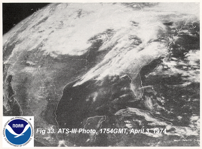
The National Oceanic and Atmospheric Administration (NOAA) issued a complete Technical Report on this tornado outbreak back in October 1975. The satellite images in the on-line PDF version are of poor quality and have been reprocessed. The images are available below. A PDF version of the report is available:
Warning: The following file is VERY Large (7.6Mb). You may want to download it (use right mouse button) and view it from your hard drive rather then try to click on the following link.
NOAA Technical Report, "Tornado Outbreak of April 3-4, 1974: Synoptic Analysis"
NOTE: Adobe Acrobat Reader is required to view/print the above PDF file.
Satellite Images from the Report: NOAA ATS-III Photo, 1511 GMT, April 3, 1974
NOAA ATS-III Photo, 1754 GMT, April 3, 1974
NOAA ATS-III Photo, 2100 GMT, April 3, 1974
Selected U.S. City and State Extremes
The Selected U.S. City and State Extremes gives a listing of new records that were set across the U.S. during April 1999.
Additional Resources
NCDC Climatic Extremes and Weather Events
NCDC NEXRAD National Mosaic Reflectivity Images (national radar composites)
Yesterday's Severe Weather Reports (list)
Yesterday's Severe Weather Reports (map)
NOAA NWS Office of Meteorology Monthly U.S. Disaster Map
Links to Numerous Natural Disaster Web Sites
National Drought Mitigation Center- U.S.
Disaster Relief Agency (news reports and information)
NOAA Special Global Summary for April 1999
USDA Wildland Fire Assessment System
NOAA CEOS Disaster Management Support Project
1999 Killer Tornadoes
Monthly Tornado Statistics
For further information, contact:
Tom Ross
NOAA/National Climatic Data Center
151 Patton Avenue
Asheville, NC 28801-5001
phone:828-271-4499
fax: 828-271-4328
email: tom.ross@noaa.gov
Specific requests for climatic data should be addressed to: ncdc.orders@noaa.gov
Top of Page
 NCDC /
Climate Research / Climate of 1999 / April / Climate-Watch /
Search / Help NCDC /
Climate Research / Climate of 1999 / April / Climate-Watch /
Search / Help
|

