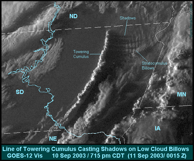
Shadowing Billows
This visible satellite image, taken shortly before sunset, shows the long late-day shadows of a line of towering cumulus. Each tall cloud tower cast its own shadow eastward across the lower clouds and ground. [For a larger image without feature labels, click here.] East of the line of cloud towers and under the shadows, there is a group of stratocumulus billow clouds -- wavy low clouds that tend to be trapped under a stable layer of air (picture example).
The weather features most responsible for the line of cloud towers were
- A cold front -- separating warm dry air to the east from cold air to the west, and
- A dryline, the boundary between warm dry air and warm moist air.
The low cloud towers were erupting as the cold front collided with, then overtook, the dryline over eastern South Dakota. The SPC surface map for two hours before the satellite picture showed a strong cold front moving eastward across central South Dakota, approachng the slow-moving dryline. Two hours after the collision, the front continued to surge eastward. When the two features merged, lift became strong enough to shove upward the warm and moist air east of the combined front and dryline, making the line of cloud towers.
Thanks to Rich Thompson (SPC) for assistance with documentation of this event.

Past Cool Images from SPC
::::: Hurricane Bertha (1996) north of Puerto Rico :::::
::::: Isolated Supercell associated with Hurricane Bertha :::::
::::: Convectively Induced Vort Max Indicated by Radar :::::
::::: California Wildfires: A Satellite View :::::
::::: Severe Hailstorm along a Gravity Wave :::::
::::: Radar Depictions of Outflow Boundaries :::::
::::: Jarrell TX F5 Tornado (27 May 97) :::::
::::: Central American Fires Spew Smoke into U.S. :::::
::::: Thunderstorm Forms over Florida Wildfire :::::
::::: Radar-detected Sunsets from Minnesota to Tennessee :::::
::::: The North Carolina Tornadocane :::::
::::: Pacific Northwest Ship Plumes :::::
::::: Heavy Snow Band as Seen from Space :::::
::::: Mexican Tornadic Supercell :::::
::::: Swath of Rain-cooled Ground :::::
::::: Radar Sampled by Thunderstorm! :::::
::::: X Marks the Distrail :::::
::::: Deadwood Smoke Plume :::::

