Created and maintained by Roger Edwards, Storm Prediction Center
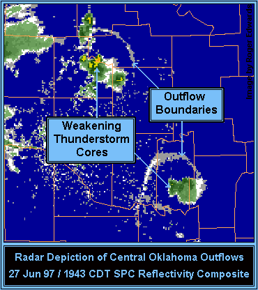
Each of the thunderstorms had been briefly more intense, but reached a point where its updraft could no longer support the load of precipitation that had accumulated inside. Since the flow and shear (change in flow with height) were both quite weak, the storms were not tilted in the vertical; so, the precipitation load collapsed down through the original updraft area of each storm. As it fell, evaporation of some of the rain cooled the downdraft, making it even more dense compared to the surrounding air. When each cool downdraft hit the ground, it spread out almost uniformly in all directions, further retarding inflow of unstable air into what was left of each storm. [Sometimes, such downdrafts are intense enough to do damage when they strike the ground and are called 'microbursts."] This radar snapshot captures a stage when the outflow rings were spreading outward away from the thunderstorms, whose cores were weakening but still identifiable.
With better-organized storms, such as supercells (persistently rotating thunderstorms that are responsible for the strongest tornadoes), there is: