
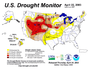
| Severe drought conditions persisted throughout much of the Intermountain West, northern Great Plains and eastward into the lower Great Lakes region during the month of April. |
larger image
|
For detailed information on drought conditions in the United States, see the regional drought pages.


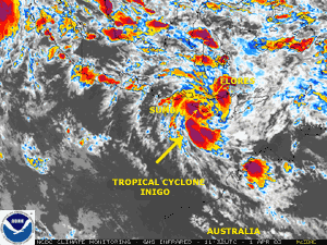
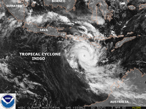
| The development of Tropical Cyclone Inigo near the Indonesian island of Sumba on April 1st brought torrential rainfall to Sumba and Flores during March 31-April 2. Mudslides on the island of Flores caused 32 deaths, with 29 of those fatalities occurring in the town of Ndona (Disasterrelief.org). |
larger image
|
In Malawi, flooding rains in early April were responsible for 4 deaths and the destruction of 530 hectares (1,300 acres) of crops (Associated Press). About 2,000 families were rendered homeless, and numerous roads and bridges were destroyed.
In Oman, thunderstorms on the 14th produced torrential rains and flash flooding in the northern part of the country leaving fourteen dead (BBC News). In Nizwa, southwest of the capital city of Muscat, 66 mm (2.6 inches) of rain fell, which is more than double the normal rainfall received in the entire month of April.
 larger image
|
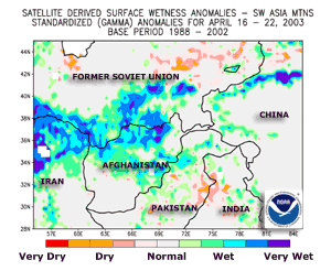
Above average precipitation continued across much of Afghanistan during early to mid April, with significant flooding reported in southern Afghanistan's Helmand province, which resulted in at least 30 deaths (OCHA).
|
Farther north in Kyrgyzstan, heavy precipitation caused a devastating landslide which hit the village of Kara-Taryk, located about 100 km (60 miles) east of Osh City. The landslide was responsible for at least 38 fatalities (OCHA). Heavy precipitation that has fallen across the southwest Asia mountain region has ameliorated long-term drought conditions that were present during 1998-2002.
| At least 4 deaths were blamed on flooding from heavy rains across Puerto Rico, Haiti and the Dominican Republic during April 12-18 (Associated Press). Three of the fatalities occurred in Puerto Rico, where three days of heavy rains culminated on the 18th. |
Click for Animation
|
 larger image
|
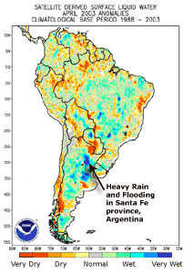
Santa Fe, Argentina was reportedly hit by the worst flooding since 1573 (BBC News). Several days of heavy rainfall caused some major rivers in the area, including the Salado River, to rise as much as 508 mm (20 inches) in 12 hours. At least 23 people were killed and over 45,000 people evacuated from the area (OCHA/GVA). By early May, the flooding was so severe that Santa Fe was characterized as an island (OCHA/GVA).
|
Heavy rains that fell in northwest Bolivia during March 31-April 1 resulted in a deadly mudslide that killed 14 people and buried dozens of homes (Reuters, OCHA). The mudslide occurred in the gold mining town of Chima, located about 580 km (360 miles) north of the capital of La Paz.
For an archive of flood events worldwide, see the Dartmouth Flood Observatory.

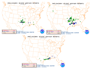
| A frontal system brought severe weather to parts of the U.S. Great Plains eastward into the lower Mississippi Valley region during April 5-7. Numerous reports of wind and hail damage were received, along with isolated tornadoes. |
larger image
|
More severe weather including tornadoes affected the southern Plains eastward into parts of the Ohio and Tennessee Valley region during the 18th-20th
In Southeast China's Guangdong province, severe thunderstorms on the 14th resulted in one death and 24 injuries (People's Daily News). Hail the size of eggs caused damage to homes and crops, and 120 mm (4.7 inches) of rain fell in the city of Nanxiong, producing severe flooding.
In Bangladesh, strong thunderstorms were blamed for capsizing a ferry which killed 130 people on the 21st (Associated Press). More severe thunderstorms caused damage to planes parked at the Dhaka International Airport on the 22nd, as strong winds also produced power outages throughout the city.

 larger image
|
Tropical Cyclone Inigo developed near Sumba on the 1st and produced locally heavy rains on Sumba and Flores. The cyclone reached maximum intensity on the 4th over open waters of the Indian Ocean, as maximum sustained winds peaked at 260 km/hr (140 knots or 160 mph). The cyclone dissipated as it crossed into Western Australia on the 8th, bringing locally heavy showers to coastal areas west of Port Hedland.
|
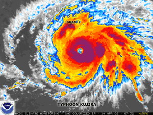
| Typhoon Kujira developed in the Pacific Ocean on the 9th and reached typhoon strength on the 12th. Kujira passed south of Guam on the 14th, producing gusty winds and locally heavy showers on the island. |
larger image
|
Kujira weakened into a tropical storm before recurving to the east of Taiwan on the 24th. The weakened remnants of Kujira passed over Japan during the 25th-26th, bringing heavy rains and winds gusting over 85 km/hr (45 knots or 50 mph).
| Tropical Storm Ana developed as a subtropical storm on the 20th and became the first Atlantic tropical storm (since records began in 1871) during the month April on the 22nd. Maximum sustained winds reached 80 km/hr (45 knots or 50 mph), although the storm remained over open Atlantic Ocean waters before dissipating on the 23rd. |
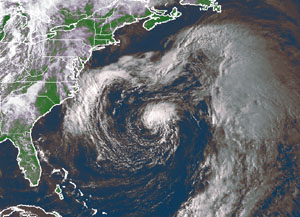
larger image
|

 larger image
|
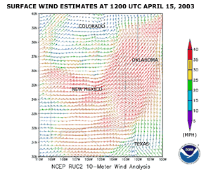
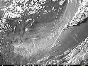
A strong frontal system which swept across New Mexico on the 15th produced strong winds gusting as high as 210 km/hr (130 mph) at the White Sands Missile Range. Sustained winds over 55 km/hr (35 mph) produced significant amounts of blowing dust which was responsible for a 10-car pileup near the town of Deming that killed 2 people (CNN).
|
 larger image
|
Strong winds and blowing dust affected a wide area from New Mexico and through much of western Texas. Strong thunderstorms erupted as the cold front pressed into Texas and Oklahoma.
|

A late season winter storm dumped up to 22 inches (56 cm) of snow across the higher elevations of the western North Carolina mountains on April 10.
 Animation
|
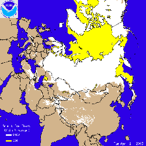
Late season snow cover began a steady northward retreat across Europe and Asia, with most of Siberia still covered by the end of the month.
|
References:
Basist, A., N.C. Grody, T.C. Peterson and C.N. Williams, 1998: Using the Special Sensor Microwave/Imager to Monitor Land Surface Temperatures, Wetness, and Snow Cover. Journal of Applied Meteorology, 37, 888-911.
Peterson, Thomas C. and Russell S. Vose, 1997: An overview of the Global Historical Climatology Network temperature data base. Bulletin of the American Meteorological Society, 78, 2837-2849.
For all climate questions other than questions concerning this report, please contact the National Climatic Data Center's Climate Services Division:
Climate Services Division
NOAA/National Climatic Data Center
151 Patton Avenue, Room 120
Asheville, NC 28801-5001
fax: 828-271-4876
phone: 828-271-4800
email: ncdc.orders@noaa.gov
For more information, refer also to ...
March 2003 Hazards and Significant Events
Selected U.S. City and State Extremes
2002 Atlantic Hurricanes
2002 U.S. Wildfire Summary
Global Historical Climatology Network (GHCN)
The Global Temperature Anomalies
CLIMVIS - Global Summary of the Day
CAMS data provided by the Climate Prediction Center
Geographic Reference Maps (pdf format)
For further information on the historical climate perspective presented in this report, contact:
Scott Stephens
NOAA/National Climatic Data Center
151 Patton Avenue
Asheville, NC 28801-5001
fax: 828-271-4328
email: Scott.Stephens@noaa.gov
-or-
Jay Lawrimore
NOAA/National Climatic Data Center
151 Patton Avenue
Asheville, NC 28801-5001
fax: 828-271-4328
email: Jay.Lawrimore@noaa.gov

 NCDC / Climate
Monitoring / Climate
of 2003 / Hazards / Help NCDC / Climate
Monitoring / Climate
of 2003 / Hazards / Help
|


