USGS - science for a changing world

Natural Hazards

Maps, Imagery, and Publications Hazards Newsroom Education Jobs Partnerships Library About USGS Podcasts/RSS

Science that Weathers the Storm: USGS Responds to Hurricane Gustav

USGS Scientific Efforts Science Response Vehicle Ready to Go

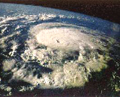
The U.S. Geological Survey continues to mobilize equipment and personnel to gather the scientific data and information on the impact of Hurricane Gustav.

USGS scientists will be:

  • Collecting satellite imagery to assess the impact on wetlands, coasts, and changes in the elevation.
  • Collecting water samples to determine the water quality in areas where there has been significant salt water intrusion.
  • Marking and flagging high-water marks to document flooding and storm surge.
  • Repairing and replacing damaged streamgages to restore flood warning capabilities.
  • Collecting aerial photography and video to document the impact on the coast and wetlands.
  • Using airborne laser mapping systems (LIDAR) to quantify coastal changes.

Need more information? View the USGS list of public affairs and state contacts.

Photo of the science response vehicle.The Science Response Vehicle is ready to be deployed from the USGS National Wetlands Research Center in Lafayette, La., in response to the possible landfall of Hurricane Gustav. The vehicle is equipped with computers, software, and plotters to provide mapping of specific data and provides a base of operations for scientific sample collection and field processing.


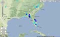
Real-Time Gulf States Storm Surge and Floods Map
Image of the real-time water data map

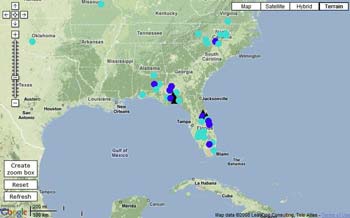
This interactive tool can be used to track storm surge and floods in real-time on Google Maps before, during and after the storm.

The map includes data from streamgages within the Gulf states, which is imperative to local, State and Federal officials in order to forecast floods and coordinate flood-response activities in the affected area.


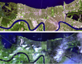
Satellite Imagery and other Geospatial Data
Image showing New Orleans before and after Hurricane Katrina.
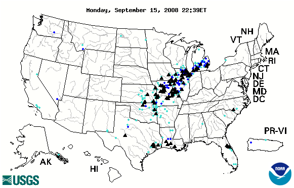
Monitoring Streamflow Conditions
Image of real-time water data map.
News Releases and Multimedia
Image representing a news release.
Additional USGS Tropical Storm/Hurricane Information
Photo showing a hurricane formattion from satellite.
Additional Hurricane Resources
Real-Time Flood and High Flow Conditions

NOAA: National Hurricane Center (Atlantic)

  • Atlantic Tropical Weather Outlook
    000 ABNT20 KNHC 170551 TWOAT TROPICAL WEATHER OUTLOOK NWS TPC/NATIONAL HURRICANE CENTER MIAMI FL 200 AM EDT WED SEP 17 2008 FOR THE NORTH ATLANTIC...CARIBBEAN SEA AND THE GULF OF MEXICO... TROPICAL CYCLONE FORMATION IS NOT EXPECTED DURING THE NEXT 48 HOURS. $$ FORECASTER PASCH

  • There are no tropical cyclones at this time.
    No tropical cyclones as of Wed, 17 Sep 2008 06:08:10 GMT


NOAA: National Hurricane Center (East Pacific)

  • East Pacific Tropical Weather Outlook
    000 ABPZ20 KNHC 170550 TWOEP TROPICAL WEATHER OUTLOOK NWS TPC/NATIONAL HURRICANE CENTER MIAMI FL 1100 PM PDT TUE SEP 16 2008 FOR THE EASTERN NORTH PACIFIC...EAST OF 140 DEGREES WEST LONGITUDE.. TROPICAL CYCLONE FORMATION IS NOT EXPECTED DURING THE NEXT 48 HOURS. $$ FORECASTER PASCH

  • There are no tropical cyclones at this time.
    No tropical cyclones as of Wed, 17 Sep 2008 06:08:10 GMT


USGS Storm Team (password required)


State Contacts:

If you would like to know more specific information about USGS Hurricane Gustav response activities in your area, please contact the appropriate person listed below.

To accompany USGS crews in the field contact Brian McCallum at 404-375-2505 or bemccall@usgs.gov

Public Affairs Contacts

Change in Emergency Call-in Procedures for USGS Employees

In the event employees are unable to contact their immediate supervisor, they should contact the USGS Emergency Call Center.

Contact information for the USGS Emergency Call Center
· Toll Free: (866) 854-8987
· TTY (hearing or speech impaired): (800) 725-7024
· Reporting via Internet: http://www.lexitelcom.com/USGS/EmployeeCalls.aspx


Accessibility FOIA Privacy Policies and Notices

Take Pride in America logo USA.gov logo U.S. Department of the Interior | U.S. Geological Survey
URL: http://www.usgs.gov/hazards/hurricanes/gustav/default.asp
Page Contact Information: Ask USGS
Page Last Modified: Friday, September 12, 2008