Natural Hazards
Back to Natural Hazards Gateway Home
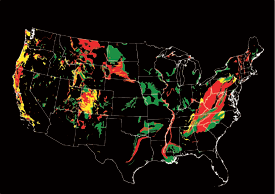
Landslide potential of the conterminous United States: Red areas have very high potential, yellow areas have high potential, and green areas have moderate potential. Landslides can and do occur in the black areas, but the potential is low. Map not to scale. Sources: the National Atlas and the USGS (Hi-res | Low-res) Natural Hazards - LandslidesLandslides occur and can cause damage in all 50 States. Severe storms, earthquakes, volcanic activity, coastal wave attack, and wildfires can cause widespread slope instability. Landslide danger may be high even as emergency personnel are providing rescue and recovery services. To address landslide hazards, several questions must be considered: Where and when will landslides occur? How big will the landslides be? How fast and how far will they move? What areas will the landslides affect or damage? How frequently do landslides occur in a given area? Answers to these questions are needed to make accurate landslide hazard maps and forecasts of landslide occurrence, and to provide information on how to avoid or mitigate landslide impacts. The U.S. Geological Survey develops methods to answer these questions to help protect U.S. communities from the dangers of landslides.
|
|
Select the
|

![]() U.S. Department of the Interior |
U.S. Geological Survey
U.S. Department of the Interior |
U.S. Geological Survey
URL: http://www.usgs.gov/hazards/landslides/default.asp
Page Contact Information: Ask USGS
Page Last Modified: Tuesday, July 08, 2008
