 |
|||||||||
skip to content |
|||||||||
Live, from Seafloor to Scientists Ashore
New NOAA ship will change how we explore the ocean
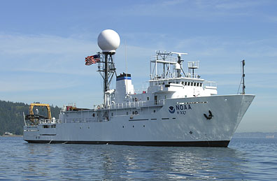
NOAA Ship Okeanos Explorer will be the only federal vessel dedicated to exploring the largely unknown ocean. Her first field season will likely begin in 2009. Credit: NOAA Image
NOAA ship Okeanos Explorer, “America’s Ship for Ocean Exploration,” is on a course to be the only U.S. ship assigned to systematically explore our largely unknown ocean for the purpose of discovery and the advancement of knowledge. Telepresence, using real-time broadband satellite communications, will connect the ship and its discoveries, live with audiences ashore.
After the ship is commissioned in Seattle August 13th, the ship and crew will undergo field tests off the U.S. West Coast to train operators and test concepts of operations and equipment associated with the ship and its sensors and systems. All this leads to the ship’s first full field season of operations in 2009, and a new way of exploring the ocean.
Why explore? All life on Earth relies on the ocean--an ocean that provides oxygen and regulates global temperature to make the Earth livable. Other key ocean benefits include food, energy and transportation.
Yet, the ocean is 95 percent unexplored, unknown and unseen by human eyes, and resource managers cannot manage what they do not know. To understand, manage and protect the ocean and its resources, NOAA believes it’s critical to support a systematic program of ocean exploration, using the best of ocean technology to explore, discover, inform, educate, and motivate. Exploration of our largely unknown ocean supports key NOAA, national, and international goals related to a better understanding of the ocean that will benefit current and future generations. NOAA views this ship as a new and valuable asset with great potential to help understand the unknown ocean.
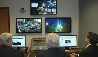
Using telepresence technology, live images and data will be transmitted from seafloor to scientists ashore at any of the five Exploration Command Centers. Credit: NOAA Image
Unlike many other ocean expeditions supported by NOAA, missions on this ship will have most of the scientists remaining ashore. Via telepresence, live images from the seafloor and other science data will flow over satellite and high-speed Internet pathways to scientists standing watches in any of five Exploration Command Centers ashore. Those scientists, and others on call if a discovery is made at sea, will add their expertise to missions no matter where in the world the ship is located.
This telepresence-enabled ship will also stream seafloor images and interviews from sea over standard Internet connections to bring the excitement of ocean exploration and discoveries live into classrooms, newsrooms, and living rooms, helping to raise ocean literacy among stakeholders, increasing their ability to make informed decisions about important ocean issues. The use of telepresence for exploring the ocean was pioneered by Dr. Robert Ballard and his Institute For Exploration.
Missions of the ship include mapping, site characterization, reconnaissance, education and outreach. Reconnaissance is searching an unknown area for an interesting anomaly and stopping the ship to investigate in greater detail, using all ship systems to focus on a specific target with high discovery potential. Additionally, the ship will conduct regular water column exploration to improve characterizations of water mass properties at sites both when searching for anomalies and when transiting through poorly known deep water areas.
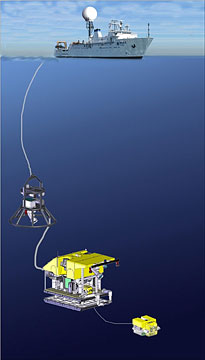
The remotely-operated vehicle (ROV) system consists of a bell-shaped camera sled, a science-class ROV and a small xBot, all of which can operate as deep as 6000 meters. Credit: NOAA Illustration with vehicle drawings by ROV Builder Phoenix International
Okeanos Explorer is a hypotheses-generating ship, a ship of discovery. Following a discovery, or a detection of a high-interest anomaly, the ship may stop and deploy remotely-operated vehicles (ROVs) and other sensors and systems. Together with shore-based exploration teams, scientists and technicians at sea may conduct preliminary additional investigations, developing enough data to provide an energized user community with justification for follow-on, hypotheses-based investigations, before the ship moves on to explore more of the unknown ocean. In this way, Okeanos Explorer is also a path-finding ship, creating a wake of discovery data for other scientists on other ships to conduct subsequent and more detailed investigations.
The ship comes with a variety of sensors and systems, including a modern hull-mounted multibeam sonar for high-resolution maps of the seafloor as deep as 6,000 meters. These maps will help explorers identify interesting features that warrant further investigation, and will serve as a guide for conducting visual surveys using the ROVs.
Okeanos has ROVs, attached by a tether and capable of operating to depths of 6,000 meters. One ROV is suspended above the other and serves to illuminate and image the surroundings. Suspended below this is the primary ROV, equipped with the same high-definition and lights, as well as special sensors and manipulators for collecting data and samples. Tucked into and operating from the main ROV is a 60-pound xBot, or penetrating ROV, that will provide exploration access to confined areas where it could be difficult or unwise to send the larger and expensive main ROV. The battery-powered xBot also has lights and cameras but of lower resolution compared to the other vehicles.
Okeanos Explorer will use its dynamic positioning (DP) system, a sort of automatic pilot that integrates satellite positioning data with the ship’s engines and thrusters, to remain on station when ROVs are deployed.
An imposing feature on the ship is the large satellite dome, part of the high-bandwidth satellite communications system that allows explorers ashore to participate in the expedition. The satellite telemetry system is designed to provide data at rates up to 21Mb/s (megabytes per second) from the ship to the shore and up to 4 Mb/s from shore back to the ship. This capability is required to support full transmission of the high definition video from both the ROVs and from auxiliary cameras on the ship.
Exploration Command Centers ashore include the “Inner Space Center” at the University of Rhode Island which will be the hub; the Joint Hydrography Center at the University of New Hampshire; Mystic Aquarium and the Institute for Exploration in Mystic, Conn.; NOAA’s Pacific Marine Environmental Lab in Seattle; and NOAA’s Science Center in Silver Spring, Maryland.
In concert with its Ocean Exploration Advisory Working Group, NOAA will review and prioritize survey areas for the Okeanos Explorer to conduct exciting and compelling voyages of discovery. Following commissioning and a series of field tests, the ship will operate in its first two years in the Pacific, generally between the tropics of Cancer and Capricorn. The ship’s missions will be chronicled at NOAA’s award-winning Web site, oceanexplorer.noaa.gov.
The ocean exploration ship was converted from the former Naval surveillance T-AGOS class ship Capable. Okeanos Explorer is 224 feet in length with a beam of 43 feet and a draft of 15 feet. The ship and can embark 46, including crewmembers and those assigned to mission support. Okeanos Explorer will be operated by officers in NOAA’s Commissioned Officer Corps and by civilians as part of NOAA’s fleet, managed by NOAA’s Office of Marine and Aviation Operations (OMAO). Exploration mission equipment will be operated by NOAA’s Office of Ocean Exploration and Research (OER).
SHIP SPECIFICATIONS
- Name: Okeanos Explorer, from the Greek "Okeanos," for ocean
- History: Former Naval surveillance T-AGOS Class ship Capable
- Length: 224 feet Beam: 43 feet Draft: 15 feet
- Berthing: 46, including crew and mission support
- Mission: Mapping, site characterization, reconnaissance, and education and outreach.
- Telepresence: Live images from seafloor to scientists ashore, and to classrooms, newsrooms and living rooms. Telepresence was developed with the support of Dr. Robert Ballard and the Inner Space Center at the University of Rhode Island.
- ROVs (remotely-operated vehicles): Two vehicles attached by a tether, capable of operating to depths of 6,000 meters.
- Dynamic Positioning (DP): Automatic pilot for ships, keeping the ship in place while operating ROVs.
- Mapping: Hull-mounted, first-of-its-kind multibeam sonar for high-resolution maps of the seafloor as deep as 6,000 meters.
- Staff: Ship operated by the NOAA Commissioned Officer Corps and civilians as part of NOAA's fleet managed by NOAA's Office of Marine and Aviation. Mission equipment operated by NOAA's Office of Ocean Exploration and Research.
- Commissioned: August 13, 2008 in Seattle, Washington
Outreach and education are important mission components of NOAA ship Okeanos Explorer, and will be supported by the ship, NOAA’s Office of Ocean Exploration and Research (OER), and NOAA’s Office of Marine and Aviation Operations (NMAO).
Key outreach objectives are to:
- Establish and increase understanding of and excitement for Okeanos as an icon ship for exploring the largely unknown ocean.
- Brand the ship as “America’s ship for ocean exploration.”
- Communicate ocean discovery news quickly and widely.
- Engage audiences ashore in creative and interactive ways so they become virtual crewmembers of Okeanos and its exploration team afloat and ashore.
View images from commissioning ceremony
See related article in Spotlight Archive
The Office of Ocean Exploration is NOAA's center for new activities to explore and better understand our oceans. This office supports expeditions, exploration projects, and a number of related field campaigns for the purpose of discovery and the advancement of knowledge. |
8/12/08
CLIMATE · OCEANS, GREAT LAKES, and COASTS · WEATHER
and AIR QUALITY
ABOUT US · RESEARCH
PROGRAMS · EDUCATION · HOME