 |
|||||||||
skip to content |
|||||||||
From Seafloor “Live” to Scientists Ashore
 Data
from NOAA Ship Okeanos Explorer Will Take New Directions
Data
from NOAA Ship Okeanos Explorer Will Take New Directions
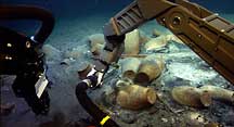
During the August 2007 expedition to the Black Sea, the high-tech arm of the undersea robot HERCULES investigates ancient shipping jars at the site of a Byzantine-era shipwreck. The images were sent worldwide live via telepresence technology. (larger) Credit: Institute for Exploration and Institute for Archaeological Oceanography
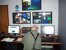
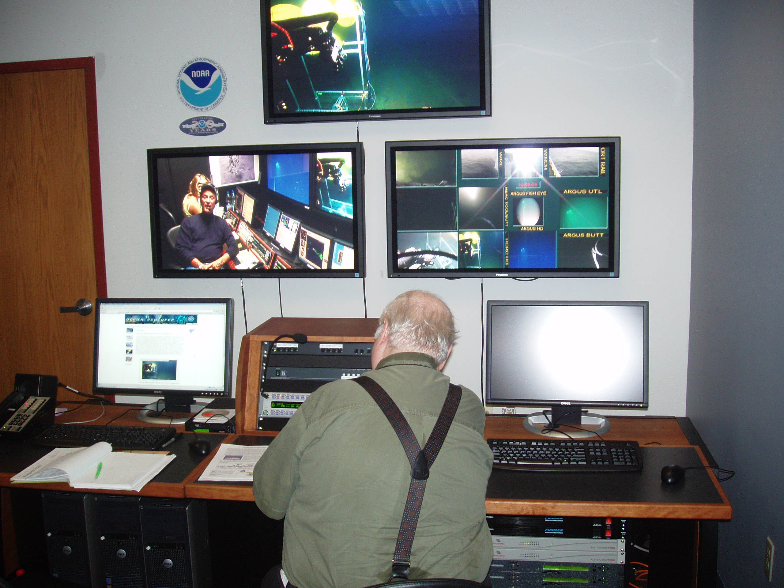
Associated Press reporter Randy Schmid interviews Dr. Bob Ballard live from NOAA's Exploration Command Center in Silver Spring. Ballard was on a research vessel in the Black Sea where his underwater robots were sending live images from the seafloor to pods of scientists ashore, and by standard Internet to classrooms, newsrooms and living rooms worldwide. (larger) Credit: NOAA
At the bottom of the Black Sea off Ukraine, in a sprawling warehouse in Largo Maryland, and in the waters of Puget Sound in Washington State, three subplots are now underway that will fold into a single story next year and change how NOAA explores the ocean.
In the Black Sea, the well-preserved remains of a 1,000-year-old Byzantine ship lie on the seafloor with its undelivered cargo jars scattered about. Close by, underwater robots called remotely operated vehicles (ROV’s) illuminate the scene and send video images up a cable to a research vessel where famed explorer Robert Ballard works with a team to send images and other science data on to pods of scientists stationed at, or called in to, “Exploration Command Centers” ashore. It’s the latest in a series of ocean expeditions to refine “telepresence technology,” the satellite and Internet pathways that will deliver data next year from NOAA’s new exploration vessel Okeanos Explorer.
Data will come from the ship via satellite and high-speed Internet to “scientists on call” ashore when Okeanos Explorer makes a discovery of note, or when the ships multibeam sonar or other sensors find an anomaly that requires further investigation, perhaps by sending down ROVs. High-Speed Internet2 connections will share data with scientists at Exploration Command Centers at the University of New Hampshire’s Joint Hydrographic Center where NOAA is a partner, at NOAA facilities in Silver Spring, Maryland, at Pacific Marine Environmental Laboratory in Seattle, and at Ballard’s Institute for Exploration in Mystic, Connecticut. An “Inner Space Center” at the University of Rhode Island is the command and control center for all the telepresence operations ashore.
NOAA will determine where Okeanos Explorer will sail to methodically explore unknown or poorly known ocean areas, primarily using multibeam sonar sweeps to map the ocean floor, but employing other sensors regularly to measure conductivity, temperature and depth of ocean water, and to obtain samples for possible medical applications. But the ship may change plans, headings, and emphasis, depending on whether there is a discovery, and if so, those changes may trigger calling in scientists ashore.
It’s a new paradigm in ocean exploration in several respects. The ship will be exploring more than researching, generating rather than testing hypotheses. With more scientists participating, or on call ashore, more intellectual capital will be available to a mission, and those scientists can delay or change the ship’s mission, based on what is discovered. Another part of the new paradigm is that the data from the ship and its systems will flow as quickly as possible to the widest audience of scientists and other stakeholders.
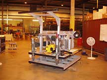
Okeanos Explorer's 6,000 meter science-class ROV under construction at Phoenix International, in Largo, MD. The high frame in the front is to accommodate lights and the vehicle's HD video camera. The yellow vehicle in the center of the ROV is the xBOT, a small penetrating robot that will be housed at that location on the main ROV in a yet-to-be-constructed cage. (larger) Credit: NOAA Office of Ocean Exploration |
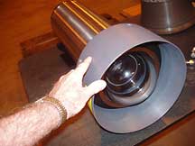
This high-definition video camera, rated for a depth of 6,000 meters, will be attached to the ROV to send images ashore in near-real time via satellite and high-speed Internet pathways. (larger) Credit: NOAA Office of Ocean Exploration |
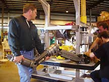
Ocean engineers at Phoenix International move one of the ROV's two manipulator arms to test the required lengths of connector hoses that will deliver hydraulic oil to power the arm, and to ensure the arm will operate in all directions without impacting other equipment to be installed on the ROV frame. (larger) Credit: NOAA Office of Ocean Exploration |
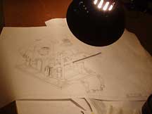
A workbench light illuminates a drawing of the ROV showing the vehicle partially fitted with the syntactic foam that will make the ROV neutrally buoyant. (larger) Credit: NOAA Office of Ocean Exploration |
Plans are to commission the ship in the summer of 2008 in preparation for a full field season of exploration in 2009. When operational, the ship will be the nation’s only vessel specifically designed and dedicated to searching, mapping and characterizing the planet’s largely unknown ocean. It’s a big job, with 95 percent of the ocean unexplored, unseen by human eyes.
Robotic eyes, in the form or standard and high definition video cameras, have been delivered to Largo, Maryland. There, Phoenix International, the firm awarded a contract to build the suite of ROVs, or remotely-operated-vehicles, will soon attach them to the framework of the science-class ROV that will serve NOAA’s and the nation’s exploration interests, down to 6,000 meters depth.
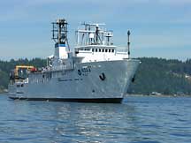
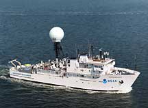
During sea trials at the end of Phase 1 refitting, the ship and shipyard crew tested the dynamic positioning system used to keep the vessel on station. Sea trials are being conducted in Puget Sound, just north of Blake Island, WA. (larger) Credit: NOAA Office of Ocean Exploration
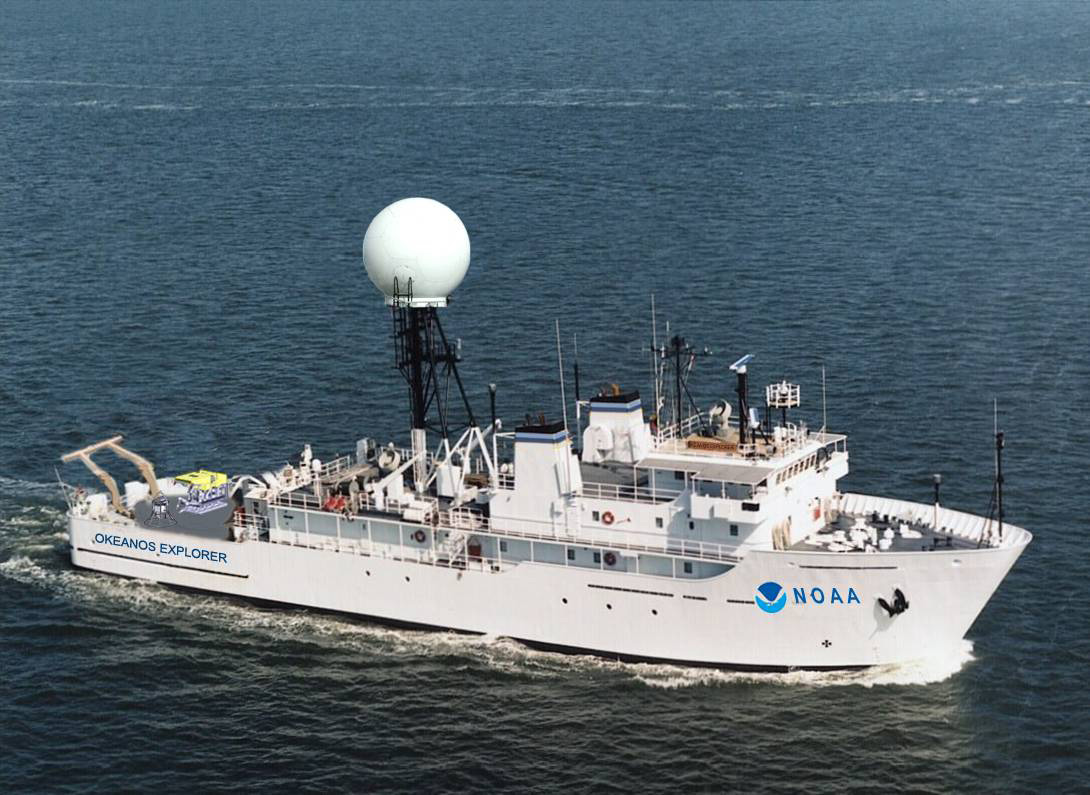
This image was created to show how Okeanos Explorer will look after two phases of shipyard refitting are completed. The large dome will support ship-to-satellite connections that are part of telepresence. (larger) Credit: NOAA Office of Ocean Exploration
The three-vehicle robotic system includes a bell-shaped sled with cameras and lights that will operate near the seafloor, and it is tethered to the main ROV for the purpose of tether management and surge protection. The main science-class robot, equipped with cameras, lights, twin robotic arms and claws, and other systems, including six thrusters that can power the robot in any direction desired by the pilot who is “flying” the robot from the research vessel above. Highly compressed syntactic foam will cover most of the robots, making them “neutrally buoyant,” and thus more easily moved by the thrusters. The science robot will operate on a shorter umbilical from the camera sled, and a very small “xBot,” a penetrating robot, will operate from the main robot.
Okeanos Explorer has just completed Phase I of a two-phase shipyard refitting, and is engaged in sea trails in Puget Sound to test the ship’s engines and systems. One of the first systems to be tested was the ship’s “dynamic positioning,” or “DP” system just installed at the shipyard. DP takes information from equipment on the ship including a global positioning system or “GPS” reading, and automatically works the ship’s engines to keep Okeanos Explorer within a given location, a factor needed for the safe and efficient operation of undersea robots far below the surface.
When equipment and lessons from the Black Sea, from the ROV builder and from sea trials come together, Okeanos Explorer is expected to become an icon ship for ocean exploration. Missions for the first two years are expected to focus in the Pacific Ocean basin, including the Northwestern Hawaiian Islands, but the ship will operate worldwide, between the Tropics of Cancer and Capricorn.
Not only will scientists be tuned in via high-speed Internet, but others will be virtual explorers as they receive live streaming images of the ships operations and discoveries, as those images flow through standard Internet connections to classrooms, newsrooms and living rooms worldwide. Okeanos Explorer will bring the excitement and joy of ocean discovery to new audiences and will advance exploration, science, research and education in our ocean world. Every day now is one day closer to casting off all lines, and sailing to explore the unknown.
NOAA Ocean Explorer is an educational Internet offering for all who wish to learn about, discover, and virtually explore the ocean realm. It provides public access to current information on a series of NOAA scientific and educational explorations and activities in the marine environment. The site provides a platform to follow explorations in near real-time, learn about exploration technologies, observe remote marine flora and fauna in the colorful multimedia gallery, read about NOAA’s 200-year history of ocean exploration, and discover additional NOAA resources in a virtual library. |
8/28/07
CLIMATE · OCEANS, GREAT LAKES, and COASTS · WEATHER
and AIR QUALITY
ABOUT US · RESEARCH
PROGRAMS · EDUCATION · HOME