RMGSC National Wildland Fire Applications
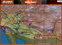 |
Geospatial Multi-Agency Coordination (GeoMAC)
GeoMAC is an internet-based mapping application designed to allow Fire Managers and the Public access to dynamically displayed online maps of current fire locations and fire perimeters in the continental U.S. and Alaska. The GeoMAC application is an indispensable tool for aiding fire-personnel by dynamically displaying the most current forest-fire information available from a web browser. The RMGSC developed and maintains the site which received over 48.5 million user requests in 2006. |
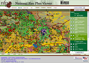 |
National Fire Plan Web Mapping
The National Fire Plan was developed in August 2000, following a landmark wildland fire season, with the intent of actively responding to severe wildland fires and their impacts to communities while ensuring sufficient firefighting capacity for the future. The NFP addresses five key points: Firefighting, Rehabilitation, Hazardous Fuels Reduction, Community Assistance, and Accountability. The National Fire Plan Maps website is an internet-based mapping application that visually portrays the Department of Interior and Department of Agriculture land management agencies' hazardous fuels program projects in relation to the wildland urban interface communities. These are communities that are within the vicinity of federal lands that are at high risk from wildland fire. The hazardous fuels program reduces the impacts of unwanted wildland fires on communities, natural resources, and cultural resources. Past disruptions of natural fire cycles, as well as other management practices, have resulted in wildfires of increasing intensity and severity. Treatment of hazardous fuel will help reduce the impacts of wildfires on communities and restore health to fire-adapted ecosystems. |
 |
National Fire Plan Operations & Reporting System (NFPORS)
The National Fire Plan Operations and Reporting System (NFPORS) is an interagency system designed to assist field personnel in managing and reporting accomplishments for work conducted under the National Fire Plan. NFPORS is used by the five federal wildfire agencies to track Hazardous Fuels Reduction (HFR) and Burned Area Rehabilitation (BAR) treatment projects. NFPORS provides comprehensive National Fire Plan data starting with FY03. NFPORS is the system of record for planning and reporting accomplishments for these two NFP key points. RMGSC personnel developed, implemented, and maintain the spatial portion of NFPORS. The current mapping tool supports NFPORS requirements in three ways: First, it provides a confident method for locating and verifying location for project and treatment units for Hazardous Fuels Reduction and Burned Area Rehabilitation projects; Second, it provides additional location-based information to the NFPORS database (e.g. Congressional District, County); and Third, it provides a mechanism for making and printing maps suited for project execution, guidance, reports, or display. The current mapping tool is a point-based system. In FY06, a polygon-based prototype system was developed. The polygon-based system is being implemented in FY07. |
 |
California Interagency Fire Plan
The Fire Planning and Mapping Tools Website is a user-friendly public website. Users can create maps of an area, print, and download data to their PC for use with GIS software. The application provides critical GIS data needs in a timely fashion to meet the needs of communities. This comes at a critical time when community fire protection planning is now required in order to receive grant funding through Federal programs such as the Healthy Forests Initiative, Healthy Forests Restoration Act, and the National Fire Plan. The site allows fire personnel, in the field, to upload their fire perimeters. This capability keeps the Fire Planning site current and provides a central storage location for fire perimeter data. |
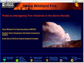 |
South Sierra Geographic Information Cooperative (SSGIC) & Sierra Wildland Fire Reporting System (SWFRS)
These applications are being developed by the USGS RMGSC for the Southern Sierra Fire Management Officers from Bureau of Land Management, USDA Forest Service, and National Park Service. The SWFRS application is a prototype comprehensive reporting system for all federal fires in the southern and central Sierra Nevada range. The purpose of this reporting system tool is to enhance fire managers' ability to collaborate and better understand fire and smoke impacts across multi-agency landscapes. This application provides reporting forms and tools for digitizing point and perimeter locations for small fires. Dispatchers are able to enter fire information as the information becomes available. A primary function of this system is providing real-time air quality information to the California Air Quality Advisory Board during prescribed-burn operations. The current site has web links to cameras located throughout the area which are used to view the smoke conditions. Links to Real-Time Smoke Monitoring sites using Beta Attenuation Mass monitors (BAMs) are provided. BAMs measure particulates in the air, specifically smoke. Each monitor can measure either or both 2.5 and 10 micron particulates depending on the filters used. The web site is updated hourly with 5-minute averages from the operating site. |
 |
The RMGSC currently hosts the Geospatial Task Group website. The GTS is a coordinated point of contact dedicated to providing high-quality information and expertise on the use of geospatial data, standards, applications, and processes in support of interagency wildland fire management. Through sharing information the GTG is committed to improving fire safety and wildland fire management and supporting all wildland fire activities including planning, incident management, education, prescribed burns, and various other activities. |
For More Information Contact: Elizabeth Lile OR John Guthrie

![]() U.S. Department of the Interior |
U.S. Geological Survey
U.S. Department of the Interior |
U.S. Geological Survey
URL: http://wildfire.usgs.gov/
Page Contact Information: Website Manager
Page Last Modified: Tuesday, 18-Mar-2008 13:54:13 Mountain Daylight Time
