Weather
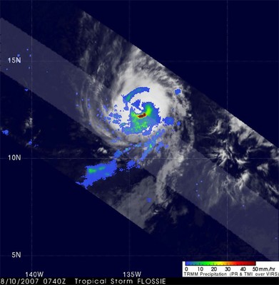
This image shows Tropical Storm Flossie as it was moving westward in the East Pacific shortly before it became a hurricane. The image was taken by the Tropical Rainfall Measuring Mission (or TRMM) satellite at 07:40 UTC on the 10th of August 2007 and shows the horizontal pattern of rain intensity within the storm. Rain rates in the center of the swath are from the TRMM PR, and those in the outer swath come from the TRMM Microwave Imager (TMI). The rain rates are overlaid on infrared (IR) data from the TRMM Visible Infrared Scanner (VIRS). Although the storm is still fairly asymmetric with most of the rain (blue and green areas indicating light to moderate rain intensities, respectively) south of the center, an eye is beginning to emerge, and there is good banding (curvature) in the rain field. There is also an area of more intense rain (dark indicative of a mature, intense hurricane. At the time of this image, maximum sustained winds were estimated at 55 knots (63 mph) by the National Hurricane Center.
The weather system includes the dynamics of the atmosphere and its interaction with the oceans and land. Weather includes those local or microphysical processes that occur in minutes through the global-scale phenomena that can be predicted with a degree of success at an estimated maximum of two weeks prior. The Weather theme is important to the NASA Earth Science for two reasons. First, the improvement of our understanding of weather processes and phenomena is crucial in gaining an understanding of the Earth system. It is directly related to the Climate and Water/Energy Cycle Themes. In both cases, the dynamics are to a large degree controlled by "weather processes." Second, there is an infrastructure in the U.S. for operational meteorology at NOAA, the FAA, the DoD, and others that requires the introduction of new technologies and knowledge that only NASA can develop.
NASA has been a strong contributor to the National weather forecasting goals in the past, and will continue in the future, primarily through the development and use of data from space-based sensors. Satellite-based profiles of temperature and moisture have been routinely used in the operational system for more than two decades, and new NASA sensors hold promise for more accuracy and spatial resolution. A geostationary Lightning Mapper Sensor (LMS) will provide dramatic improvements in the operational use of sounding data for real-time diagnosing of severe storms. Recent developments in the assimilation of radar and passive microwave data from TRMM and the Advanced Infrared Sounder (AIRS) data from Aqua have been shown to improve weather forecasts.
NASA has partnered with NOAA and DoD to develop a Joint Center for Satellite Data Assimilation (JCSDA). The mission of the JCSDA is to accelerate and improve the quantitative use of research and operational satellite data in weather, ocean, climate and environmental analysis and prediction models. In addition, the Short-term Prediction Research and Transition (SPoRT) center is transitioning the data from NASA research satellites to the NOAA National Weather Service (NWS) Weather Forecast Offices (WFOs).