Climate
NASA's role in characterizing, understanding and predicting climate variability and change is centered around providing the global scale observational data sets on the higher-inertia components of the climate system (oceans and ice), their forcings, and the interactions with the entire Earth system. Understanding these interactions goes beyond observations, but includes developing and maintaining a modeling capability that allows for the effective use, interpretation, and application of the data. The ultimate objective is to enable predictions of change in climate on time scales ranging from seasonal to multi-decadal. As we pioneer new satellite measurements to enable this capability, we work with our agency partners to transition our demonstrated observational capabilities to operational capabilities run by other agencies.
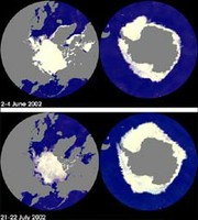
The National Space Development Agency of Japan's Advanced Microwave Scanning Radiometer - EOS (AMSR-E) is one of six key Earth-observing instruments on board Aqua and has recently been used to obtain images of the sea ice covers of both polar regions, showing their changes from the June 2-4 period to the July 21-22 period. In these images, white indicates the area of sea ice cover and gray indicates land. Because of the time period covered (late spring to summer in the Northern Hemisphere; late fall to winter in the Southern Hemisphere), the area of the ice cover in the Arctic region is decreasing while the area of ice cover in the Antarctic region is increasing, a fact captured very well in these images.
Fueled by the important space-based perspective, we have learned much over the last several decades. Among the more recent discoveries have been that ice cover in the Arctic Ocean is shrinking, as has ice cover on land, as temperatures have warmed over the last two decades. In the Antarctic, such trends are not apparent, except for in a few select locations. Satellite altimetry has made a major contribution to being able to measure and monitor recent changes in global circulation and has contributed valuable insight into the net upward trend in sea level that may threaten coastal regions in the future.
The climate system is dynamic, and modeling is the only way we can effectively integrate the current knowledge of the individual components. Through modeling studies we can estimate and project the future state of the climate system. However, we don't have the full understanding of the processes that contribute to the climate variability and change. The future work will be to eliminate model uncertainties through better understanding of the processes.
NASA data and analyses will ultimately enable more accurate climate prediction, characterization of uncertainties, and the development of scenarios that are more likely to reflect the realities of the future. Many advances in such capabilities in the last few decades are a direct result of our investments in instrumentation and research. Such prediction capabilities are critical to effective management of resources.