|
|

 |
 |

Coastal Monitoring and Observations |
Authorizing Mandates | NOS Monitoring and Observation Programs
 |
|
|
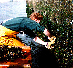
An NOS scientist collects mussels in San Diego Bay, California, for the National Status & Trends Mussel Watch Project. This monitoring program analyzes bivalve mollusks for hydrocarbons, biphenyls, pesticides, trace elements, and other contaminants.
|
 |
|
Coastal monitoring refers to periodic measurements of physical, chemical, biological, and meteorological phenomena in the nation’s oceans (out to the continental shelf break), nearshore coastal waters such as bays and estuaries, and terrestrial environments that affect the use and quality of the marine environment. Monitoring also can be thought of as the collection and analysis of repeated observations and measurements to evaluate changes in environmental conditions and to assess progress toward meeting an environmental management objective.
NOAA’s National Ocean Service (NOS) supports 28 monitoring and observation systems while carrying out its marine transportation and coastal and ocean stewardship responsibilities. Nineteen of these systems are national in scope. Monitoring and observations to conduct NOS hydrographic surveying and geodetic and chartmaking functions can be traced back to 1807, when President Thomas Jefferson established the Survey of the Coast. NOS ecosystem monitoring responsibilities can be traced to the 1970s, when oil leasing off the coast of Alaska and ocean dumping of sewage sludge and dredge material in coastal waters of the New York Bight necessitated the collection of baseline ecological data. For NOS, monitoring is a process to document the status and trends of resources and natural phenomena for which it has statutory authority.
 |
|
|
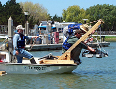
NOS scientists prepare equipment for sediment sampling in San Francisco Bay, California. This monitoring is part of the National Status & Trends Benthic Surveillance Project to determine the level of 70 organic and inorganic contaminants in surficial sediments nationwide.
|
|
|
Authorizing Mandates
Four pieces of federal legislation authorize most NOS monitoring programs:
- The Marine Protection, Research, and Sanctuaries Act authorizes the National Status and Trends Program, national marine sanctuary monitoring, the Coastal Change Analysis Program, and benthic habitat assessment mapping.
- The Coastal Zone Management Act authorizes harmful algal bloom monitoring, the National Estuarine Research Reserve System-wide Monitoring Program, and South Florida benthic community monitoring.
- The Clean Water Act provides authority for the national marine sanctuary monitoring, land cover change analysis, and benthic habitat assessment and mapping.
- The Coast and Geodetic Survey Act authorizes most NOS monitoring activities related to charting and navigation, including hydrologic surveying, the Physical Oceanographic Real-time System, the National Water Level Observation Network, the National Spatial Reference System, and the Shoreline Mapping Program.
Several other pieces of legislation such as the Comprehensive Response, Compensation, and Liability Act and the Outer Continental Shelf Lands Act also authorize NOS coastal monitoring.
(top)
NOS Monitoring and Observation Programs
Coastal monitoring programs generally fall into one of three classes that are usually differentiated by their geographic scale. Those in the first class measure environmental features simultaneously across large geographic areas. They use sensors or instruments that are carried on airplanes, satellites, or ships and monitor features such as shoreline change, sea surface temperature, and land use. The NOS nationwide monitoring programs that fall into this class are:
- Benthic Habitat Assessment Mapping – This project maps bottom habitat throughout the coastal regions of the United States using satellite and airborne sensors, acoustic imaging, videography, photography, and benthic community analysis. The project is used to establish baseline habitat distributions and assess change over time.
- Coastal Change Analysis Program – This program employs remote sensing to classify land cover in coastal upland and wetland habitats, and is used to document changes in these areas over time.
- Continuously Operating Reference Stations (CORS) – This network of more than 1,100 fixed-position reference stations receives Global Positioning System (GPS) data 24 hours a day, seven days a week. The data collected at these stations allow GPS users to compare their GPS information to that collected at CORS stations and improve location accuracy.
- Coral Reef Mapping – Aerial photographs of nearshore waters are used to create maps of coral reefs, seagrass beds, mangrove forests, and other important habitats for fisheries, tourism, and other aspects of the coastal economy.
- Environmental Sensitivity Index Maps – More than 3,300 of these maps, which cover the majority of the U.S. coastline, include information on shoreline geomorphology in 10 major categories, including areas of wetlands and tidal flats. The maps are used to evaluate coastal erosion potential and coastal storm vulnerability and monitor coastal change.
- Harmful Algal Bloom Monitoring – This program consists of intensive, short time-scale monitoring of a number of physical, chemical, and biological properties at several sites in Maryland and Florida where harmful algal blooms have occurred.
- Hydrographic Surveying – These surveys measure water depth and emphasize elements that affect safe navigation. Surveys identify sea-floor material, dredging areas, pipelines, wrecks, piles, and fishery habitats.
- National Spatial Reference System (NSRS) – This is a coordinate system that defines position (latitude and longitude), elevation, distance and direction between points, strength of gravitational pull, and how these values change over time. The NSRS is used as a foundation to precisely locate transportation, communication, and defense systems, and enables NOS to monitor movements of the Earth's crust and changes in elevation.
- Shoreline Mapping Program – This program uses aerial photography to survey 95,000 miles of U.S. coast to produce a digital database of the national shoreline.
- Topographic Change Mapping – This observing program uses Light Detection and Ranging (LIDAR) to collect high-resolution topographic and other spatial data for information on beach and dune topography and is used in coastal-zone decision making.
 |
|
|
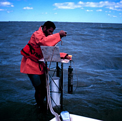
Collecting data for the System-wide Monitoring Program at the Chesapeake Bay Virginia National Estuarine Research Reserve. Data logger instrumentation shown here samples temperature, salinity, dissolved oxygen, water clarity and acidity at a minimum of two sites in each reserve at continuous 30-minute intervals.
|
|
|
The second class of monitoring programs characterizes chemical, physical, meteorological, or biological properties by making repeated measurements at selected sites throughout a region. The purpose of these programs is usually to collect information on specific resources or specific human-induced environmental stresses. The porgrams involve periodic sampling and analysis either at a site or in the laboratory. NOS nationwide monitoring programs that fall into this class are:
 |
|
|
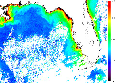
This is a satellite image from October 1997, used for monitoring harmful algal blooms. The red pigment indicates the possible increase in concentration of Gymnodinium breve cells, a species of algae that, at certain concentrations, can cause neurotoxic shellfish poisoning.
|
|
|
The third class of monitoring programs usually involve intensive and frequent measurements of environmental conditions at only a few sampling locations. These programs allow scientists to identify, measure, and potentially link environmental changes detected by the other two types of monitoring with the causes of these changes. The NOS nationwide monitoring programs that fall into this class are:
- Coral Reef Ecosystem Monitoring – This is a nationally coordinated, long-term monitoring program for U.S. coral reefs.
- National Marine Sanctuary System – Each of the 14 national marine protected areas within the Sanctuary System conducts site monitoring tailored to meet the needs of the individual sanctuaries, usually directed at key resources within the areas.
- National Status & Trends Bioeffects Assessments – These studies determine the incidence, severity, and spatial extent of biological effects of contamination in coastal waters. They are used in conjunction with information from National Status & Trend sites where potential for substantial environmental degradation is high.
- Physical Oceanographic Real-Time System – This is a real-time observation system for water levels, currents, and other oceanographic and meteorological data to help ships avoid groundings and collisions in 13 major U.S. ports.
Finally, observation or monitoring programs that are conducted only at a local level are associated with the following NOS programs:
(top)
|
|


