WaterWatch -- Current Water Resources Conditions

Current Maps/Graphs:
Flood Watch:
Drought Watch:
Recent/Historical Maps/Graphs:
Special Features Contents Hurricane Ike Map

WaterWatch -- Current water resources conditions

State Streamflow Google Map (Select a state from the list.)

AlabamaAlaskaArizonaArkansasCaliforniaColoradoConnecticut
DelawareDistrict of ColumbiaFloridaGeorgiaHawaiiIdahoIllinois
IndianaIowaKansasKentuckyLouisianaMaineMaryland
MassachusettsMichiganMinnesotaMississippiMissouriMontanaNebraska
NevadaNew HampshireNew JerseyNew MexicoNew YorkNorth CarolinaNorth Dakota
OhioOklahomaOregonPennsylvaniaRhode IslandSouth CarolinaSouth Dakota
TennesseeTexasUtahVermontVirginiaWashingtonWest Virginia
WisconsinWyomingPuerto Rico    
New England      

Water-Resource Region Streamflow Google Map (Select a region from the list.)

New EnglandMid AtlanticSouth Atlantic-GulfGreat LakesOhio
TennesseeUpper MississippiLower MississippiSouris-Red-RainyMissouri
Arkansas-White-RedTexas-GulfRio GrandeUpper ColoradoLower Colorado
Great BasinPacific NorthwestCaliforniaAlaskaHawaii
Puerto Rico    

Non-U.S. Streamflow Google Map (Select a country or a region from the list.)

CanadaEl SalvadorGuatemalaHondurasNicaraguaCentral America region 

Build Regional Streamflow Google Map

Select states or regions from the drop-down button or from the map. Click "GO" to create a Google Map.
(Due to limitation of Google Map, limit to two regions or four states)
Regions:
 

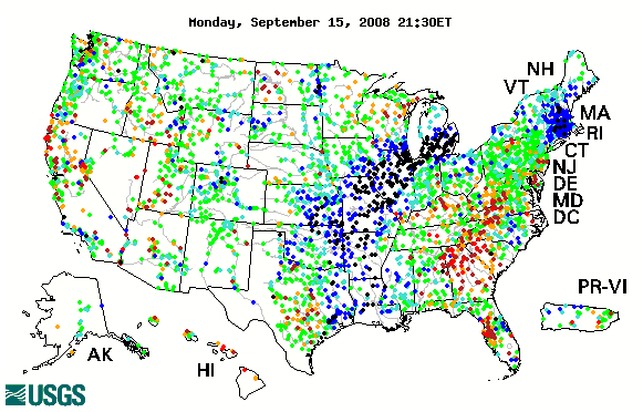
Map of Streamflow Conditions

flow condition map wa id mt me or mn nd mi nh wi vt ny sd wy ma ca ct ri nv pa ia ut ne oh nj il in co wv de md va mo dc ks ky az nc nm tn ok tx ar sc ga al ms la fl ak hi pr vt nh ma ri ct nj de md dc

Accessibility FOIA Privacy Policies and Notices

Take Pride in America logo USA.gov logo U.S. Department of the Interior | U.S. Geological Survey
URL: http://water.usgs.gov/waterwatch
Page Contact Information: Contact USGS
Page Last Modified: Wednesday, September 17, 2008