|
Hydrologic Impacts...
Crop |
% Poor or Worse |
% Fair or Better |
Corn |
33 |
67 |
Cotton |
15 |
85 |
Peanut |
3 |
97 |
Soybean |
28 |
72 |
Livestock |
13 |
87 |
Pasture |
20 |
80 |
Top soil moisture profiles have improved following our recent
rainfall. Only nineteen percent of soils are now indicated as being
dry or very dry. Although sub soil moistures may have benefited
slightly from the recent rainfall...deficits still exist as
evidenced by some farm ponds beginning to dry up once again as less
rainfall occurred over the area.
The USDA states that the condition of some row crops has shown some
improvement following recent rainfall The rainfall has helped the
peanut and cotton crops...and livestock have shown some slight
improvement as pasture conditions have improved a little.
The latest reports from the USDA are to the right.
Fire Danger Impacts...
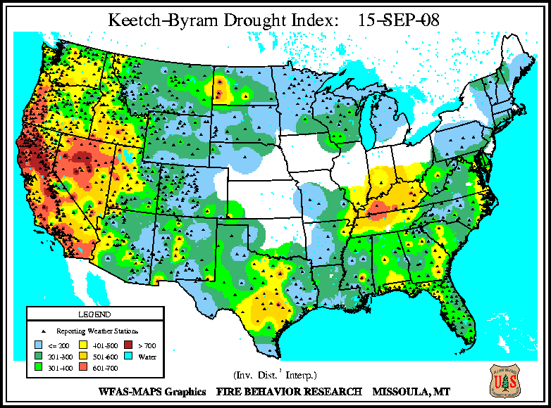
Generally speaking...the fire danger risk across Central Alabama has increased a little due to the recent fairly dry conditions. Keetch-Byram Drought Indices (KBDI) generally range from 250 to 500
with localized higher values. Values
above 500 indicate a severe fire danger.
The Alabama Forestry Commission reports that no counties are currently under a Fire Alert.

Hydrologic Summary and Outlook...
Most stream flows reported by USGS gages remain near normal or above
normal. Periodic rainfall would help maintain near normal stream
flows across Central Alabama.
Most reservoirs have leveled off or fallen a little during the past
week. Listed below are today`s levels for some of the major
reservoirs across Central Alabama and their levels immediately
following Tropical Storm Fay:
| Reservoir |
Level for 09/11/2008 |
Level for 08/28/2008 |
| Weiss |
562.9 |
563.5 |
| Neely Henry |
507.4 |
507.3 |
| Logan Martin |
464.4 |
464.7 |
| Lay |
395.7 |
396.1 |
| Mitchell |
311.7 |
311.9 |
| Jordan |
251.4 |
251.4 |
| R.L. Harris |
790.3 |
791.0 |
| Martin |
488.6 |
488.9 |
| Smith |
499.3 |
500.8 |
| Bankhead |
254.6 |
254.7 |
| Holt |
186.2 |
186.1 |
Social Impacts...
Area reservoirs have leveled off or begun to fall slowly again
following the rises that occurred in association with Tropical Storm
Fay. However...the threat of municipal water shortages has eased as
we head into September and toward cooler fall weather. Recent
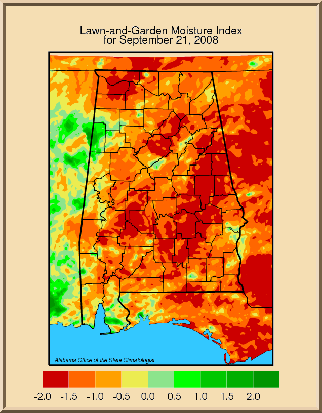
rainfall has also been beneficial to lawns and gardens...increasing
top soil moistures for plants and vegetation.
 Outlook... Outlook...
A moist southeasterly flow to the north and east of Hurricane Ike
will support scattered mainly afternoon showers and thunderstorms
across Central Alabama through Friday. High pressure aloft will
build across the area over the weekend as Hurricane Ike moves
northwest into Northeast Texas and this will help to suppress shower
activity across the area. However...a weak front is forecast to
move into the area early next week...but at this time only small
chances for rain are expected with this weather system. But...better
chances for rainfall could materialize if the remnants of Ike become
absorbed into the frontal system and impact Alabama more than is
currently expected.
The two week outlook...from September 18th through September 24th...
calls for below normal temperatures and above normal precipitation
chances.
The longer-range outlook for the remainder of September through
November is for equal chances of above normal or below normal
temperatures and equal chances of above normal or below normal
precipitation chances.
The latest seasonal drought outlook indicates some improvement of
drought conditions in the northern portions of Central Alabama.
Update Statement...
The next drought information statement will be issued around September 25th...or earlier if significant changes in the current
drought situation occur. |

 National Weather Service Forecast Office


 Back to home page