| 1 |  |
An aerial view of East Timbalier Island, the Gulf of Mexico is on the right. The sandy brown areas in the middle of the photograph are the newly created marsh and dune habitat. |
East Timbalier Island, Lafourche Parish, Louisiana Summer 1999 |
2 |  |
Here, a clear view of the direction that the island is accreting toward can be seen in the foreground of the picture. |
East Timbalier Island, Lafourche Parish, Louisiana Summer 1999 |
3 |  |
Looking from Timbalier Bay to the Gulf of Mexico. |
East Timbalier Island, Lafourche Parish, Louisiana Summer 1999 |
4 |  |
An aerial view looking out toward the Gulf of Mexico. The oil field infrastructure can be clearly seen in the lower right hand corner of the photograph. |
East Timbalier Island, Lafourche Parish, Louisiana Summer 1999 |
5 |  |
A view at the west end of the project site, dune habitat is on the right, marsh habitat is to the left. |
East Timbalier Island, Lafourche Parish, Louisiana Summer 1999 |
6 |  |
An aerial view of construction dredge pipes depositing sediment into containment areas of the restoration site to build marsh platform. The containment dikes are built to allow time for the marsh platform to accrete. |
East Timbalier Island, Lafourche Parish, Louisiana Summer 1999 |
7 |  |
An aerial with a closer view of the containment dike on the right. One interesting feature to note is the multiple outlets pumping sediment onto the island. East Timbalier Island was sediment starved, the pumping of sediments onto the marsh platform is helping the island to accrete. |
East Timbalier Island, Lafourche Parish, Louisiana Summer 1999 |
8 |  |
An image of the stable portion of the island. |
East Timbalier Island, Lafourche Parish, Louisiana Summer 1999 |
9 |  |
The Gulf of Mexico at the west end of the project. |
East Timbalier Island, Lafourche Parish, Louisiana Summer 1999 |
10 |  |
As seen from directly above the west end of the project. |
East Timbalier Island, Lafourche Parish, Louisiana Summer 1999 |
11 |  |
An overview of sediment being pumped into the containment area. |
East Timbalier Island, Lafourche Parish, Louisiana Summer 1999 |
12 |  |
Looking directly at the sediment being pumped into the containment dike. |
East Timbalier Island, Lafourche Parish, Louisiana Summer 1999 |
13 |  |
A part of the containment dike. |
East Timbalier Island, Lafourche Parish, Louisiana Summer 1999 |
14 |  |
A piece of specialized equipment called a marsh buggy. The buggy was used to bring sediments to the newly created marsh. |
East Timbalier Island, Lafourche Parish, Louisiana Summer 1999 |
15 |  |
The newly created marsh platform shows the marsh buggy tracks after working to stabilize the area. This is an after restoration image. |
East Timbalier Island, Lafourche Parish, Louisiana Summer 1999 |
16 |  |
Plastic tarps temporarily hold together the sediments that comprise the containment dike fronting the Gulf of Mexico. |
East Timbalier Island, Lafourche Parish, Louisiana Summer 1999 |
17 |  |
A view of the west end of the project area. |
East Timbalier Island, Lafourche Parish, Louisiana Summer 1999 |
18 | 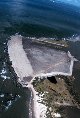 |
A close-up aerial view of the west end of the project. |
East Timbalier Island, Lafourche Parish, Louisiana Summer 1999 |
19 |  |
This view of the west end shows the oil and gas infrastructure on the island where the main pumping area is located. |
East Timbalier Island, Lafourche Parish, Louisiana Summer 1999 |
20 |  |
An overview looking west. |
East Timbalier Island, Lafourche Parish, Louisiana Summer 1999 |
21 |  |
Fishing boats at nearby Port Forchon, the newly created wetlands will help to support the numerous fishery resources found in this area. |
East Timbalier Island, Lafourche Parish, Louisiana July 2000 |
22 |  |
A test planting of smooth cordgrass on the East Timbalier marsh platform. This planting was done as restoration for the Lake Barre oil spill and was not CWPPRA funded. |
East Timbalier Island, Lafourche Parish, Louisiana July 2000 |
23 |  |
The test planting of Spartina at the East Timbalier marsh platform. |
East Timbalier Island, Lafourche Parish, Louisiana July 2000 |
24 |  |
Restoration specialists inspect the S. alterniflora plantings at the test site. |
East Timbalier Island, Lafourche Parish, Louisiana July 2000 |
25 |  |
Patchy coverage of S. alterniflora beginning to show at the test planting site on the East Timbalier marsh platform. |
East Timbalier Island, Lafourche Parish, Louisiana July 2000 |
26 |  |
The rock revetment shoreline of the restored area of East Timbalier Island. |
East Timbalier Island, Lafourche Parish, Louisiana July 2000 |
27 |  |
The rock revetment placed at East Timbalier Island helps to prevent erosion while the marsh accretes. |
East Timbalier Island, Lafourche Parish, Louisiana July 2000 |
28 |  |
A view of the east end of the island. |
East Timbalier Island, Lafourche Parish, Louisiana July 2000 |
29 |  |
This view shows a southeast exposure where areas of erosion are evident. |
East Timbalier Island, Lafourche Parish, Louisiana July 2000 |
30 |  |
A southeast exposure where erosion is evident, the rock revetments were placed to prevent loss of sediments from erosion. |
East Timbalier Island, Lafourche Parish, Louisiana July 2000 |
31 |  |
Another view of the southeastern part of the restoration area. |
East Timbalier Island, Lafourche Parish, Louisiana July 2000 |
32 |  |
A view from the southeastern part of the restoration area where erosion was a concern. |
East Timbalier Island, Lafourche Parish, Louisiana July 2000 |
33 |  |
The rock revetment was placed to prevent erosion at the restoration site. |
East Timbalier Island, Lafourche Parish, Louisiana July 2000 |
34 |  |
A view of a wide expanse of newly created marsh platform. |
East Timbalier Island, Lafourche Parish, Louisiana July 2000 |
35 |  |
The newly created marsh platform on the east end, or Bayside, of the East Timbalier Island. |
East Timbalier Island, Lafourche Parish, Louisiana July 2000 |
36 |  |
Marsh platform on the east end of East Timbalier Island. |
East Timbalier Island, Lafourche Parish, Louisiana July 2000 |
37 |  |
A dustpan dredge, the "Beach Builder", used in the restoration. |
East Timbalier Island, Lafourche Parish, Louisiana July 2000 |
38 |  |
An aerial view of the West End of East Timbalier Island. |
East Timbalier Island, Lafourche Parish, Louisiana July 2000 |
39 |  |
A pleasure boat at nearby Port Forchon near East Timbalier Island. Port Forchon is about a 20 minute boat ride from East Timbalier Island. |
East Timbalier Island, Lafourche Parish, Louisiana July 2000 |
40 |  |
An aerial view of the "Beach Builder". |
East Timbalier Island, Lafourche Parish, Louisiana July 2000 |
41 |  |
A bird's eye view of sediment being pumped onto the marsh platform. This image was used in the NOAA Restoration Center brochure that was published in May 2001. |
East Timbalier Island, Lafourche Parish, Louisiana July 2000 |
42 |  |
An extreme close up view of sediment being pumped onto the marsh platform. |
East Timbalier Island, Lafourche Parish, Louisiana July 2000 |
43 |  |
Sediment spews onto the marsh platform, the containment dike is clearly seen in the background. |
East Timbalier Island, Lafourche Parish, Louisiana July 2000 |
44 |  |
An aerial view from the west end looking at the first part of the project. |
East Timbalier Island, Lafourche Parish, Louisiana July 2000 |
45 |  |
A remote aerial view of the "Beach Builder". |
East Timbalier Island, Lafourche Parish, Louisiana July 2000 |
46 |  |
An aerial close-up view of the "Beach Builder". |
East Timbalier Island, Lafourche Parish, Louisiana July 2000 |
47 |  |
The "Beach Builder" at work. |
East Timbalier Island, Lafourche Parish, Louisiana July 2000 |
48 |  |
The "Beach Builder". |
East Timbalier Island, Lafourche Parish, Louisiana July 2000 |
49 |  |
A support tug underway, the tug ferried people and supplies to and from the restoration site and moved the dredge as needed. |
East Timbalier Island, Lafourche Parish, Louisiana July 2000 |

