|
Instruments
and methods
We use the
following tools for studying geologic processes on the Mid-Ocean Ridge
at a range of spatial scales, from broad, regional surveys to detailed,
local mapping. Within each subsection below is a map showing the general
extent of our data coverage.
- SeaBeam
multibeam sonar bathymetry
NOAA ships
are equipped with Seabeam multibeam echo sounders. Over the years, bathymetric
data from VENTS Program expeditions and other surveys have been accumulated
in a significant data base. This map
shows the extent of our SeaBeam bathymetric coverage in the NE Pacific.
Multibeam data collected by the VENTS Program have also been incorporated
into a global data base. To obtain bathymetric data, either in ping
or gridded format, visit the
RIDGE Multibeam Synthesis Project at Lamont Doherty Earth Observatory.
Data or images of multibeam data can be obtained from this web site.
Where a volcanic eruption has occurred on the seafloor, the site can
be re-surveyed with multibeam sonar and then the "before"
and "after" surveys can be quantitatively compared to look
for depth changes caused by new
lava flows. This helps to map the location, area, and volume of
the lava that was erupted. With this comparison technique we have now
documented 6 eruptions on the Juan de Fuca and Gorda Ridges since 1981.
Sidescan
sonar imagery
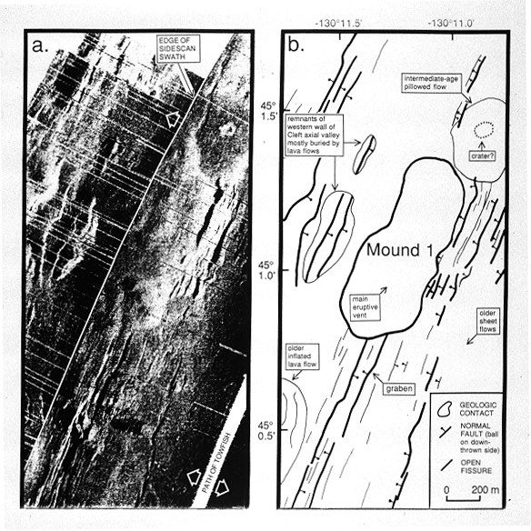
Sidescan
sonar is an instrument package that is towed behind a ship and which
produces images the seafloor that highlight its texture, morphology,
and structure. It helps to determine the size and locations of faults
and fissures, as well as lava flows
of different ages. These maps show the extent of our sidescan sonar
coverage on the Juan de Fuca Ridge, the Gorda
Ridge, and in the CoAxial/Axial
area. All
of the sidescan data on the index maps is in digital form at the NOAA/PMEL
lab at the Hatfield Marine Science Center in Newport, Oregon. Some of
these data were collected by other groups (Sea MARC II data, and SIO
DEEPTOW data by F. Spiess and J. Hildebrand) and requests for data should
be addressed to them. Requests for pre-1996 data collected by NOAA/PMEL
should be addressed to Bob Embley.
Some of these data have not been co-registered with GPS-navigated multibeam
bathymetry.
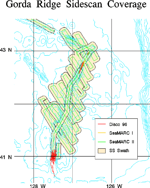
Towed
camera systems
SeaBeam
and sidescan systems give a broad view of the seafloor. Photographs
of the seafloor taken from towed camera
systems can then be used to make detailed geological studies of
selected areas within the broader context. Towed
camera sleds are capable of shooting either digital images or 35
mm film or both. The camera data are used to map the extent and distribution
of lava flows of different ages and
types on the seafloor, as well as vent sites and biological
communities. These maps show the extent of our towed camera coverage
for the Juan de Fuca Ridge and Gorda
Ridge. Since
1983, more than 100 camera tows have been made on the Gorda and Juan
de Fuca Ridges. The data from these tows include high resolution microbathymetry,
CTD data, more than 125,000 still frames, and more than 500 hours of
black and white and color video. Some of our navigation, interpreted
photogeology, and the microbathymetry data can be accessed through the
VENTS GIS
system. The original still camera and video data are archived at the
NOAA/PMEL lab in the Hatfield Marine Science Center, Newport, Oregon.
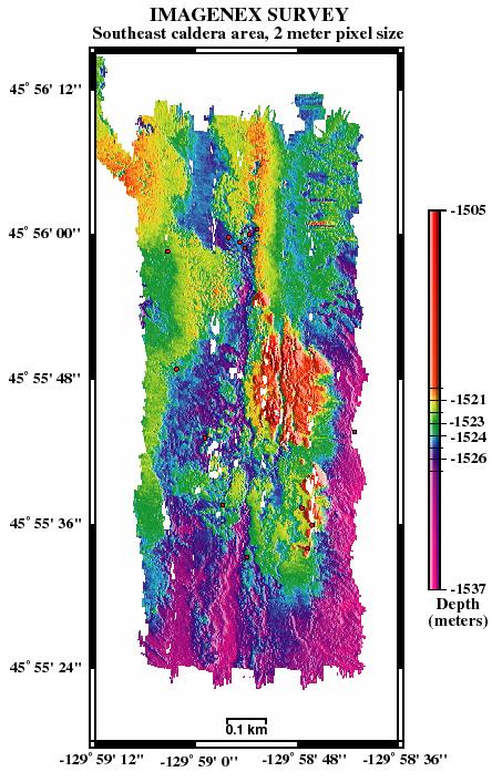
High-frequency
"pencil beam" scanning-sonars (either Mesotech or Imagenex
instruments, which are 675 kHz sonars) can be used for high-resolution
bathymetric surveys in selected areas. We have used the Mesotech
sonar mounted on the submersible ALVIN
and the Imagenex sonar mounted on the Jason and ROPOS
ROVs. The sonar data can be viewed as individual profiles or can be
gridded to make a map. The scale of the surveys (areas 100's of meters
on a side) fills a critical gap between multibeam sonar bathymetry and
the scale of submersible or camera observations, and consequently the
data reveal new spatial and morphologic relationships between geological
features on the seafloor.
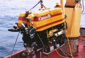
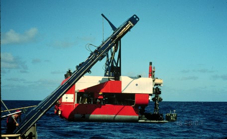
- Submersibles
and Remotely Operated Vehicles (ROVs)
Manned
submersibles or Remotely Operated Vehicles (ROV's) are used when fine-scale
geologic mapping and sampling is required on the seafloor. Lava
flow contacts can be mapped in detail, vent
sites can be explored, and hydrothermal
fluid samples can be collected.
Since 1984,
NOAA VENTS scientists have participated in more than 200 dives with
submersibles and ROV's on the NE Pacific plate boundaries. Most of these
dives have been with the submersible ALVIN (operated by Woods Hole Oceanographic Institution)
during interdisciplinary expeditions involving geologists, chemists,
and biologists from NOAA, universities, the U.S. Geological Survey,
and the Geological Survey of Canada. These ALVIN dive series have been
generously funded by the NOAA
National Undersea Research Program. In 1992 NOAA/VENTS scientists
and groups from the Canadian Geological Survey, the Canadian Institute
for Ocean Sciences, the University of Victoria, and the University of
Quebec led the first successful deep-water science program to the mid-ocean
ridge with the Canadian ROV ROPOS. During
this program, the first high temperature vent fluids were sampled from
an ROV on a mid-ocean ridge hydrothermal system. This paved the way
for the successful rapid response to the CoAxial eruption in 1993 where
ROPOS was used to map and sample the newly erupted lava. Another ROV
platform that we have used is the U.S. Navy
Advanced Tethered Vehicle (ATV), operated by SUBDEVGROUPONE, based
in San Diego. Still camera images and video for the ALVIN dives are
available through the WHOI archival facility. Still camera images and
video from the ROV dives are archived at the NOAA/PMEL lab, Hatfield
Marine Science Center, Newport, Oregon. This map
shows the extent of our submersible coverage on the Juan de Fuca Ridge.
last modified
11/09/01 by Bill Chadwick |