GRAVITY FIELD OVER THE SOUTHERN OCEAN FROM GEOSATNGDC DATA ANNOUNCEMENT NUMBER: 92-MGG-01
Color-Shaded Image from the National Geophysical Data Center
Report MGG-6K.M. Marks and D.C. McAdooNOAA/National Ocean Service/Office of Ocean & Earth Science/Geoscience Lab
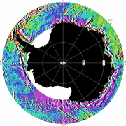
This new color-shaded gravity image, derived from GEOSAT satellite altimetry between latitudes 60 deg. S and 72 deg. S in the Circum-Antarctic region, highlights the gravitational effect of ocean floor topography. It reveals details of sea-floor relief not seen before in either gravity images or acoustic bathymetry. The image is available as a 24" x 36" poster from the National Geophysical Data Center. The circum-Antarctic marine gravity field is computed entirely from altimeter data collected by the US Navy's Geosat satellite. Geosat made direct observations of sea surface topography during its primary Geodetic Mission (GM) from March 1985 through October 1986, and its secondary Exact Repeat Mission (ERM) from November 1986 through January 1990. The densely- spaced GM ground tracks (2-3km at 60S) augmented by the more widely-spaced ERM data provide almost complete coverage of the Southern Ocean, in contrast to the very sparse traditional shipboard observations. Since the sea surface conforms closely to an equipotential of the Earth's gravity field, high-resolution gravity anomalies can be derived from the combined GM and ERM data. These gravity anomalies covering the Southern Ocean are shown in the color-shaded relief image. The gravity anomaly amplitudes range between -30 mGal (magenta) and +30 mGal (red), and are "illuminated " by a light source from 90E. Because short wavelength (less than 200 km) gravity anomalies are highly correlated with seafloor topography, fine-scale features of the ocean floor are revealed. The digital data used to produce the image are also available for download. |
