
 Feeds & Data
Magnitude 6.6 - HALMAHERA, INDONESIA
2008 September 11 00:00:03 UTC
Earthquake Details
| Magnitude | 6.6 |
|---|---|
| Date-Time |
|
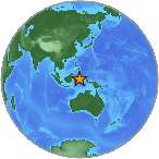
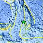
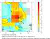
| Location | 1.875°N, 127.366°E |
| Depth | 98.3 km (61.1 miles) set by location program |
| Region | HALMAHERA, INDONESIA |
| Distances | 120 km (75 miles) N of Ternate, Moluccas, Indonesia 285 km (175 miles) E of Manado, Sulawesi, Indonesia 1575 km (980 miles) SSE of MANILA, Philippines 2460 km (1520 miles) ENE of JAKARTA, Java, Indonesia |
| Location Uncertainty | Error estimate not available |
| Parameters | NST=381, Nph=381, Dmin=607.7 km, Rmss=0 sec, Gp= 14°, M-type=regional moment magnitude (Mw), Version=8 |
| Source |
|
| Event ID | us2008wvab |
- This event has been reviewed by a seismologist.
- Did you feel it? Report shaking and damage at your location. You can also view a map displaying accumulated data from your report and others.
Earthquake Summary
Felt Reports
Felt (V) at Galela and Loloda; (IV) at Bitung and Ternate and (III) at Gorontalo and Manado.
Earthquake Information for Asia
Earthquake Information for Indonesia
 Tsunami Information
- NOAA West Coast & Alaska Tsunami Warning Center
- NOAA Pacific Tsunami Warning Center
- Tsunami Information Links
The earthquake locations and magnitudes cited in these NOAA tsunami bulletins are very preliminary and may be superceded by USGS locations and magnitudes computed using more extensive data sets.
Earthquake Maps


Scientific & Technical Information

Additional Information, News Reports
- Preliminary Earthquake Report
- U.S. Geological Survey, National Earthquake Information Center:
World Data Center for Seismology, Denver
