skip to content program navigation
| Learn more about these WEATHER RESEARCH areas... |
Forecasting Support Systems
Weather forecasting has come a long way since its formal inception in the mid to late 19th century. Today we have computers, weather models, satellites, radar, ground-based observing systems and we use numerical weather prediction. Currently, forecasters can look at their computer screens, track the radar and satellite images and make a prediction, in large part due to the development of information systems such as AWIPS.
Modernizing the Weather Service
NOAA Research and its many labs have been the research partner and one of the driving forces behind the development of new systems and tools to help the National Weather Service (NWS) modernize its operations. Back in the 1980's, while satellites, radar and other forecasting tools were spitting out data, no overall system existed that could integrate all the data and display it for the forecaster. With the development of AWIPS (Advanced Weather Interactive Processing System) all that changed. AWIPS revolutionized weather forecasting by providing forecasters with volumes of weather data that are current and easy to access. It is an interactive computer system that integrates all meteorological, hydrological, satellite, and radar data into one computer workstation and provides a superior method for forecasters to prepare and issue timely, accurate forecasts and warnings. It also enables forecasters the capability to view, analyze, combine, and manipulate large amounts of graphical and alphanumeric weather data. The AWIPS system was developed at the Forecast Systems Laboratory (now ESRL) and then transferred to the National Weather Service's 121 weather forecast offices, 13 river forecast centers and 5 national centers for environmental prediction.
New AWIPS-related Research
GFE
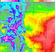
The Graphical Forecast Editing Suite was developed at the Earth System Research Laboratory (ESRL) for use by National Weather Service (NWS) forecasters. It is a new way of looking at data that permits the forecaster to insert specialized knowledge of weather conditions in a particular area into the forecast and to draw or edit the image on the computer. This graphical forecast can then be displayed as both a text forecast and a graphic. Most of the 120 NWS offices have some version of this software and are able to make gridded forecast products.
FX-Net
FX-Net is designed as an inexpensive PC workstation system for use in a variety of forecast, training, education and research applications which don't require a full AWIPS system. A project in the Global Systems Division of ESRL, it has been used to support meteorology classes at Plymouth State University and the University of New Hampshire in New Hampshire and the University of Northern Iowa. One of its most important uses has been to assist NWS meteorologists in the field or IMETS, who are forecasting fire weather. The National Interagency Fire Center (NIFC) also use FX-Net as their primary forecasting tool. Forecasters use it to assist the fire management team in positioning fire fighters on the fire line and in moving people out of harm's way.
Clean-Up Efforts in the Aftermath of Katrina
An All-hazards Meteorological Response System (AMRS) has been developed by NOAA's National Weather Service to support the NWS Incident Meteorologists (IMETs) who deal with a variety of disasters that threaten life, property or other valuable resources at remote locations. The core component of the system is the Earth System Research Laboratory FX-Net system. The AMRS can be used throughout the country wherever wildfire, chemical spills, and other catastrophes threaten. In the aftermath of hurricane Katrina, rescue and evacuation operations were supported by an IMET who was on the scene at the New Orleans Weather Forecast Office (WFO) (Slidell) on August 30. Additional IMETs were deployed to Baton Rouge, LA and Stennis Space Center, MS. The IMETS used FX-Net extensively to access information for their weather briefing and HAZMAT forecasts, assisting in the clean-up efforts.
Haz-Collect
The Earth System Research Laboratory is now working on an automated message handling system which will collect and disseminate non-weather hazardous event information to the public using the AWIPS system . Seventeen different types of HazCollect messages ranging from Earthquake and Avalanche Warnings to Hazardous Materials and Radiological Hazard Warnings to Amber Alert messages will utilize this new system. The messages will be formatted and sent via the satellite broadcast network to the appropriate NWS Forecast offices where they will be collected and stored in the AWIPS text database. The messages will be broadcast through the local media and NOAA Weather Radio. This whole process will be designed to run in a matter of seconds with little or no human intervention once a message is composed.
NEXRAD
At the same time that ESRL began working on the AWIPS system, the National Severe Storms Laboratory (NSSL) in Norman, OK, was continuing its work on modernizing weather radars using Doppler radar. NSSL was at the forefront of Doppler radar research and early-on realized that radar was to be a vital tool for weather forecasters. Before the lab's formal inception in 1964, the National Severe Storms project had established a Weather Radar Lab and the lab has been actively pursuing this research since then. The result was the WSR-88D radar, more commonly known as NEXRAD (next generation radar) which was developed, and tested at NSSL. NEXRAD was developed as a joint project between the NOAA National Weather Service, the Federal Aviation Administration and the Department of Defense. In the 1990's, the radars were installed at 150 NWS sites throughout the country. These new radar systems replaced the old weather radars which had been in operation since 1957. NOAA's NWS recently approved taking the first steps to upgrade all the WSR-88D Doppler radars in the NEXRAD network with polarimetric technology. Polarimetric capabilities will complement information the Doppler radars already provide on wind, precipitation and storm motion.
Satellites
No doubt you have seen some of the dramatic hurricane images on your evening news programs or on CNN recently, showing the eye of a hurricane swirling towards the United States. These images and many others, all come from NOAA satellites, which are managed by the National Environmental Satellite, Data, and Information Service (NESDIS). NESDIS provides access to global environmental data from satellites and other sources. They are also involved in research and in educational outreach. NOAA Research works closely with NESDIS on various satellite research projects.
A surface temperature image taken from the Graphical Forecast Editing Suite (GFE) shows the influence the local terrain has on the surface temperature.
FX-Net Display of Colorado Wildfires |

NOAA Research programs that
develop tools for Analyzing Weather
Data
![]() Earth
System Research Laboratory (ESRL)
Earth
System Research Laboratory (ESRL)
![]() National
Severe Storms Laboratory
National
Severe Storms Laboratory
NOAA Operational Groups
![]() National Weather Service (NWS)
National Weather Service (NWS)
![]() National Environmental Satellite, Data, and Information Service
(NESDIS)
National Environmental Satellite, Data, and Information Service
(NESDIS)