| STANDARD
AIRCRAFT SPECIFICATIONS
| Type: |
Engines
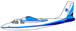
De Havilland DHC-6 Twin Otter, Series 300
United Aircraft of Canada Limited PT6A-27
(turboprop) |
| Crew: |
2
Pilots + 6 Scientists |
| Ceiling: |
12,500
feet (without supplemental cabin oxygen)
25,000 feet(with supplemental cabin oxygen) |
| Rate
of Climb: |
1600
feet/minute |
| Operational
Airspeeds: |
80-160
knots
Electrical Two 28 VDC 250 ampere starter-generators |
| Scientific
Power: |
3
KVA of 115 VAC, 60 Hz and 70 A of 28 VDC |
| Max.
Gross Weight: |
12,500
lbs. |
| Empty
Weight: |
8,100
lbs. |
| Useful
Load: |
4,400
lbs. (fuel, personnel, cargo) |
| Fuel
Load: |
2,500
lbs. with additional 1,000 lbs. in optional cabin
auxiliary tank (Note: installation of auxiliary
tank reduces useful load) |
| Type
Fuel: |
Jet |
| Standard
Fuel Burn: |
Normal
Cruise Speed - 580 lbs./hr
Fuel Burn for specific mission configuration will
be calculated during mission planning and will vary
with environmental conditions. Maximum Range and
Duration Vary with power setting and fuel tank configuration. |
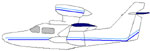
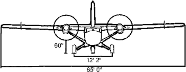
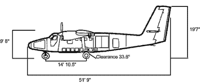
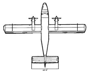
| Dimensions
(external): |
Wing
Span - 65 ft.
Total Length - 52 ft
Fuselage Height - 9 ft 1 in
Tail Height - 19 ft 6 in
Cabin Doors (removable) - 50 in x 56 in
Baggage Doors (rear) - 35.7 in x 25.7 in
(nose - see diagram) |
| Dimensions
(internal): |
(Cabin
Length - 18 ft 5 in
Cabin Height - 59 in
Cabin Width - 52.5 in (floor) 63.2 in (ceiling)
Useable Volumes Cabin - 384 cu ft
Nose Baggage - 38 cu ft
Aft Baggage - 88 cu ft |
| Additional
Standard Equipment (Cockpit): |
Weather
radar, radar altimeter, dual GPS/Loran-C navigation
system, HF radio |
| Additional
Standard Equipment (Cabin): |
Camera
and instrumentation ports GPS data link to cockpit
GPS units
Dye marker drop tube |
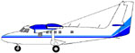
Front View
Left
Side View
Twin
Otter Mission Profile Information
| Auxiliary
Fuel Tank Installed |
| Configuration
|
Airspeed |
Endurance |
Range |
| Normal
Cruise |
130
kts |
6.0
hrs |
780
nm |
| Survey
Speed |
110
kts |
7.0
hrs |
785
nm |
| Auxiliary
Fuel Tank Removed |
| Configuration
|
Airspeed |
Endurance |
Range |
| Normal
Cruise |
130
kts |
4.5
hrs |
560
nm |
| Survey
Speed |
110
kts |
5.0
hrs |
565
nm |
Note:
According to FAA and NOAA AOC regulations, the aircraft
must land with 30 minutes fuel reserve in VFR/day conditions,
45 minutes in VFR/night conditions, and 1 hour in IFR
conditions. Additionally, endurance is relative to desired
airspeed and will be reduced if flight plans include
profiles (climbs/descents). Other factors influencing
endurance and range include but are not limited to weather,
winds aloft, and altitude. Although the auxiliary fuel
tank has a maximum capacity of 150 gallons of jet fuel,
the ability to carry this quantity if affected by weight
limitations.
- Auxiliary
fuel tank is removable.
- Dye
marker drop tube is removable.
- Instrumentation
hatch can be removed for continuous access to belly
instrumentation and camera ports.
- Various
camera mounts are available from the NOAA AOC for
nose and belly camera ports.
NOAA
Air Resources Laboratory
"Mobile
Flux Platform"
The
NOAA Air Resources Laboratory (ARL) developed modifications
to the Twin Otter in order to measure eddy fluxes and
concentration gradients through the atmospheric mixed
layer. Rates of exchange of several atmospheric properties
throughout the lower atmosphere and between the atmosphere
and the surface can now be investigated. In addition
to the advanced pressure-port system that provides absolute
velocity data, the unique nose cone al so accommodates
infrared H2O/CO2 analyzers and net radiation sensors.
When the Mobile Flux System is fully deployed, the fast
response temperature, water vapor, and carbon dioxide
sensors in conjunction with the global positioning system,
provide routine data on vertical eddy fluxes of temperature,
water, and carbon dioxide can be extracted. Other implementations
includes air temperature, dew point, pressure, three
dimensional winds, and radiation state-variable instruments.
The platform can also acquire air chemistry data, such
as NO, NOx, Noy, SO2, O3, CO, and reactive hydrocarbons,
using a flow-through air inlet system with instruments
situated in equipment racks. The acquisition system
is computer-based with four display monitors mounted
throughout the aircraft allowing in-flight interactions
by scientific users.
The
Twin Otter provides a stable platform for low level
research flights. Instrumentation is calibrated for
data acquisition at airspeeds between 100-110 knots.
With all of the atmospheric flux and air chemistry equipment
on board the aircraft, room for the installation of
the internal fuel tank is unavailable. Therefore, the
maximum endurance is approximately 4.3 hours.
Further
"Mobile Flux Platform" information can be
found by visiting the NOAA ARL website at http://www.oar.noaa.gov/ERL/ARL/welcome.html
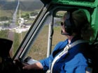
Overview

Cabin Views
Fisheries
Survey Platform
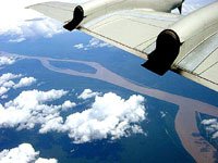
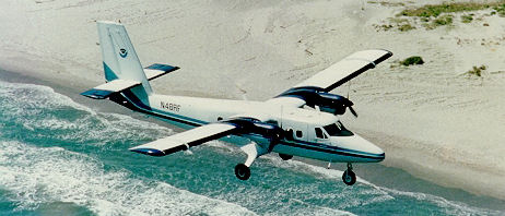
The
Twin Otter is a safe, stable platform for offshore low
level marine animal surveys. In the past, the NOAA Twin
Otters have been utilized to assess populations of many
species of pinnipeds, cetaceans, fish, and sea turtles.
The aircraft is routinely flown at 90-110 knots during
survey flights and is highly maneuverable enabling smooth
execution of steep turns. HF radios allow for communications
when the aircraft is a long distance from the shoreline.
While most animal surveys are flown during the day and
under visual flight rule conditions (VFR), the aircraft
is equipped for flight into instrument meteorological
conditions (dual VOR, dual ADF, dual GPS, DME, color
weather radar) and icing conditions (pitot heat, prop
deice, wing and horizontal stabilizer deicing boots,
engine intake deflectors).
An
internal fuel tank located in the middle right side
of the cabin carries a maximum of 150 gallons of additional
fuel (depending on payload) allowing for maximum range
and endurance. With a maximum fuel load, only four observers
can accompany the aircraft on a mission flight.
When
the large convex Plexiglas bubble windows are installed
on both sides of the forward end of the cabin, the scientific
observer has complete forward, lateral, rear, and downward
visibility. Observers can easily view both sides of
the transect line, which is a requirement of the line
transect survey method. The aft-most side window is
removable to facilitate photography. Additionally, a
nose camera port and a belly camera port is available
for video or still photographic missions. Two smaller
ports forward of the belly camera port can be used to
mount downward looking instrumentation, such as infrared
sensors or light meters. A global positioning system
(GPS) data drop is located next to the workstation situated
aft of the internal fuel tank. With a suitable laptop
computer and software package, time, date, latitude,
longitude, speed, heading information and GPS signal
strength can be downloaded from the aircraft GPS.
Further
information can be obtained from accessing the following
websites: www.nmfs.noaa.gov/mar_mammals.htm,
www.nmfs.noaa.gov/prot_res/species/cetaceans/cetaceans.html,
and www.nmfs.noaa.gov/prot_res/PR2/Conservation_and_Recovery_Program
Airborne
Oceanographic LIDAR Project
NOAA/NASA
Joint Study
NASA
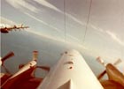
Airborne Oceanographic Lidar III mounted over the
belly camera port. View through cargo doors on left
side of a NOAA Twin Otter.
|
|
The
NOAA Coastal Services Center and NASA’s Wallops
Flight Facility mount an Airborne Oceanographic Lidar
III (AOL III) in the Twin Otter. Surveys are conducted
along the coast at 500 - 2200 feet above ground. The
AOL Fluorosensor package acquires measurements of fluorescence
from certain oceanic pigments, which include chlorophyll,
and phycoerythrin from marine phytoplankton and chromophoric
dissolved organic matter. The AOL package operates two
lasers: one laser stimulates fluorescence from chlorophyll
and phycoerythrin pigments in phytoplankton while the
other laser stimulates fluorescence from specific organic
carbon molecules. For each laser pulse, the laser-induced
fluorescence spectrum (370 nm to 740 nm spectral band)
is collected. Additionally, the fluorosensor collects
passive (solar-induced) ocean color radiance data and
sea surface temperature. Historically, AOL mission data
has had marine and terrestrial applications that include
hydrography, oil film thickness measurement, overland
terrain mapping, phytoplankton pigment measurement,
sea ice thickness estimation, and algorithm development
for satellite ocean color sensors.
NASA
Airborne Oceanographic Lidar III mounted over the belly
camera port. View through cargo doors on left side of
a NOAA Twin Otter.
Further
information can be obtained from accessing the NOAA
Coastal Services Center website at http://coastal.er.usgs.gov/cfcg/
or the NASA Wallops Flight Facility website at http://aol.wff.nasa.gov/aoltm.html.
Airborne
LIDAR Assessment of Coast Erosion
NOAA/NASA
Joint Study
The
NOAA Coastal Services Center and NASA’s Wallops
Flight Facility mount an Airborne Topographic Mapper
(ATM-II). The ATM-II, a scanning LIDAR altimeter, measures
topography to an accuracy of ten to twenty centimeters
by combining measurements from the laser altimeter (mounted
over the belly camera port) and GPS receivers. High
resolution topographic maps can be developed using these
measurements. Surveys are conducted along the coast
at altitudes between 1800 and 2200 feet above ground.
Data
from initial and follow-up surveys will be used by NOAA
and NASA scientists to assess the effects of major storms
and long term erosion patterns. Coastal features, stable
areas, and areas vulnerable to flooding, storm surge,
etc. can be depicted on color-coded maps. The data obtained
from ATM survey flights can be used to detect temporal
changes, cliff retreat or erosion, and barrier island
washover.
Further information can be obtained from accessing the
NOAA Coastal Services Center website http://www.csc.noaa.gov/crs/ALACE
or the NASA Wallops Flight Facility website http://aol.wff.nasa.gov/aoltm.html
.
|