![[NCEP Logo]](https://webarchive.library.unt.edu/eot2008/20080916171444im_/http://www.nhc.noaa.gov/graphics/ncep.gif)
Text-only version
(printer friendly)
TROPICAL CYCLONE REPORTS
Tropical Storm Allison
Tropical Depression Two
Tropical Storm Barry
Tropical Storm Chantal
Tropical Storm Dean
Hurricane Erin
Hurricane Felix
Hurricane Gabrielle
Tropical Depression Nine
Hurricane Humberto
Hurricane Iris
Tropical Storm Jerry
Hurricane Karen
Tropical Storm Lorenzo
Hurricane Michelle
Hurricane Noel
Hurricane Olga
|
Tropical Cyclone Report
Tropical Storm Jerry
6 - 8 October 2001
Jerry was a poorly-organized, short-lived tropical storm that
passed through the Windward Islands with minimal impact.
a. Synoptic History
A westward-moving tropical wave crossed the west coast of Africa
and entered the tropical Atlantic on 1 October. The wave's cloud
pattern changed little in organization until 4 October, when the
associated deep convection increased and exhibited some curved
banding in the vicinity of 40W longitude. The system did not become
significantly better organized for a couple more days, as it
continued westward. On 6 October, the deep cloudiness become more
concentrated and it is estimated that a tropical depression,
Twelve, formed by 1200 UTC that day, about 540 n mi east-southeast
of Barbados.
A ridge of high pressure in the lower- to mid-troposphere
steered the tropical cyclone on a heading slightly north of west at
15-20 kt. There was fairly weak vertical shear over the system, and
the depression strengthened into Tropical Storm Jerry around 0000
UTC 7 October. Jerry's sustained winds increased to their maximum
speed, estimated near 45 kt, as the storm approached the Windward
Islands on 7 October. A little later that day, the center of the
tropical cyclone passed a short distance south of Barbados. As it
moved through the Windward Islands around 0000 UTC 8 October, Jerry
apparently made a jog to the northwest and temporarily decreased
its forward speed. There may also have been a northward
re-formation of the center; aircraft data showed evidence of
multiple low-level centers along a northeast-southwest axis around
that time.
After passing near St. Vincent around 0300 UTC on the 8th,
Jerry moved into the eastern Caribbean Sea, its forward speed increasing
to near 20 kt. Moderate northwesterly shear was disrupting the
upper-level outflow, and the system lacked a single, well-defined
center of circulation. Later on the 8th, Jerry's
organization deteriorated further while the system was moving
rapidly westward about 200 n mi south of Puerto Rico. The tropical
cyclone then dissipated.
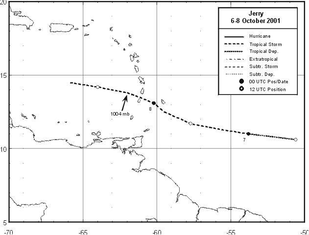
A map of the path of Jerry is presented in Figure 1, and the
"best track" positions, intensities and minimum pressures of the tropical
cyclone are given in Table 1.
b. Meteorological Statistics
Observations in Jerry (Figure 2 and Figure 3)
include satellite-based
Dvorak technique intensity estimates from the Tropical Analysis and
Forecast Branch (TAFB), the Satellite Analysis Branch (SAB) and the
U. S. Air Force Weather Agency (AFWA), as well as flight-level
winds and surface wind estimates from the 53rd Weather
Reconnaissance Squadron of the U. S. Air Force Reserve Command. The
highest wind speed reported at flight level (around 1000 ft) by
aircraft was 56 kt at 2013 UTC 7 October, and 80 percent of this
value corresponds to the maximum intensity estimate for the storm.
The minimum central pressure estimate, 1004 mb at 0600 UTC 8
October, is based on an aircraft-extrapolated value. However,
because the center was elongated, the aircraft was unable to close
off a unique center and provide a "vortex message" around that
time.
An automated station, Caravelle (number 78922, station elevation
33 m), at Martinique reported a sustained (10 minute average) wind
of 39 kt with gusts to 50 kt around 0600 UTC 8 October. There were
no ship reports of tropical storm force winds associated with
Jerry. A ship with call sign FNOR reported a wind of 110/33 kt at
15.3N 60.9W at 0600 UTC 8 October. Barbados reported a minimum
pressure of 1007 mb at 1900 and 2000 UTC 7 October.
c. Casualty and Damage Statistics
There were no reports of damages or casualties associated with
Jerry.
d. Forecast and Warning Critique
Because Jerry was a tropical storm for only 36 h, the average
track forecast error values should not be considered meaningful.
For the most part, the official and model forecast tracks correctly
took Jerry on a west to west-northwestward heading into the eastern
Caribbean Sea.
The official forecasts did not anticipate that Jerry would
dissipate over the Caribbean. In fact, the majority of the NHC
advisories indicated that the cyclone would become a hurricane in
2-3 days. Most of the SHIPS model forecasts, and quite a few of the
coupled GFDL model forecasts, showed the system reaching hurricane
strength in 48-72 h as well.
Table 2 lists the watches and warnings associated with Jerry.
The tropical storm warnings were issued only about 9 h prior to the
arrival of the center in the Windward Islands.
Table 1: Best track for Tropical Storm Jerry, 6 - 8 October 2001.
Date/Time
(UTC) | Position | Pressure
(mb) | Wind Speed
(kt) | Stage |
| Lat. (°N) | Lon. (°W) |
| 06 / 1200 | 10.6 | 50.6 | 1008 | 25 | tropical depression |
| 06 / 1800 | 10.8 | 52.1 | 1007 | 30 | " |
| 07 / 0000 | 11.0 | 53.8 | 1007 | 35 | tropical storm |
| 07 / 0600 | 11.3 | 55.7 | 1007 | 40 | " |
| 07 / 1200 | 11.7 | 57.7 | 1007 | 45 | " |
| 07 / 1800 | 12.5 | 59.5 | 1007 | 45 | " |
| 08 / 0000 | 13.1 | 60.2 | 1006 | 45 | " |
| 08 / 0600 | 13.8 | 62.0 | 1004 | 45 | " |
| 08 / 1200 | 14.2 | 64.0 | 1007 | 35 | " |
| 08 / 1800 | 14.5 | 66.0 | 1008 | 25 | tropical depression |
| 09 / 0000 | | | | | dissipated |
| 08 / 0600 | 13.8 | 62.0 | 1004 | 45 | minimum pressure |
Table 2: Watch and warning summary, Tropical Storm Jerry, 6 - 8 October 2001.
| Date/Time | Action | Location |
| 06/2100 | Tropical storm watch | Barbados |
| 07/0900 | Tropical storm watch | Tobago and Grenada |
| 07/1200 | Tropical storm watch replaced by tropical storm warning | Barbados |
| 07/1200 | Tropical storm watch | St Vincent and the Grenadine Islands |
| 07/1800 | Tropical storm watch replaced by tropical storm warning | Grenada, St Vincent and the Grenadine
Islands |
| 07/2100 | Tropical storm warning discontinued | Barbados |
| 08/0000 | Tropical storm watch discontinued | Tobago |
| 08/0000 | Tropical storm warning replaced by tropical
storm watch | Grenada |
| 08/0900 | Tropical storm warning discontinued | St Vincent and the Grenadine Islands |
| 08/0900 | Tropical storm watch discontinued | Grenada |

Figure 1:
Best track positions for Tropical Storm Jerry, 6-8 October 2001.
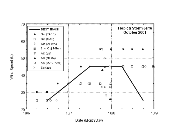
Figure 2:
Best track maximum sustained surface wind speed curve for Tropical Storm
Jerry, 6-8 October 2001. Aircraft observations have been adjusted for
elevation using 90%, 80%, and 80% reduction factors for observations from
700 mb, 850 mb, and 1500 ft, respectively. Dropwindsonde observations
include actual 10 m winds (sfc), as well as surface estimates derived from
the mean wind over the lowest 150 m of the wind sounding (LLM), and from the
sounding boundary layer mean (MBL).
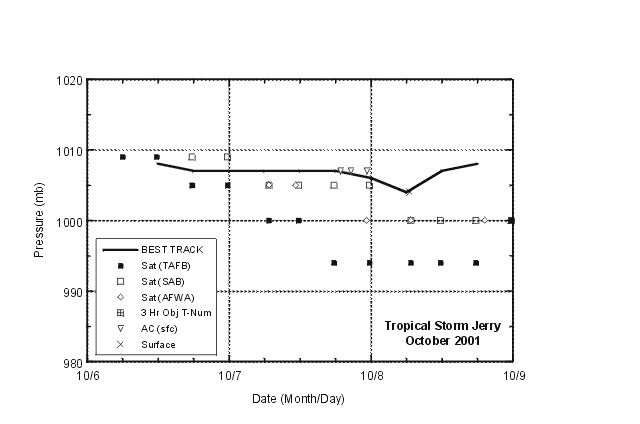
Figure 3:
Selected pressure observations and best track minimum central pressure curve
for Tropical Storm Jerry, October 2001. The observation marked with an "X"
is an aircraft-extrapolated value in this case.
|