skip to content program navigation
| Learn more about these WEATHER RESEARCH areas... |
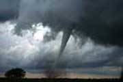
Tornadoes and Thunderstorms
NOAA's research labs study many aspects of thunderstorms from damaging winds to hail, lightning, and tornadoes. We use modeling, direct observation through field studies and past weather data in order to better understand when and where severe weather will occur. Such knowledge will improve the accuracy and amount of lead time of forecasts and warnings issued by the NOAA National Weather Service.
How We Study Thunderstorms and Tornadoes:
Instruments and Field Studies:
The National Severe Storms Laboratory explores using
radar for weather detection. They developed the prototype Doppler
radar in the 1970s and 1980s which led to the deployment of Doppler radars
nationwide (called WSR-88D, or NEXRAD). NSSL is beginning to test a new
type of radar for weather detection called phased
array that scans the sky approximately 6 times faster than the current
Doppler radars. And they recently made a modification to Doppler radar
called dual polarization that will provide meteorologists much more detail
about the internal workings of storms than before. NSSL extends this
work to analysis of the radar data itself, exploring how various algorithms
might process data to extract information forecasters need most. A division
of the Earth System Research Lab studies very low frequency sound waves,
or infrasound,
caused by severe storms, earthquakes, and tsunamis and is exploring if
such signals can be used for prediction or detection of tornadoes. They
have also developed a miniature
water vapor DIAL instrument that measures water vapor (moisture) in
the low levels of the atmosphere. Collection of moisture is one of several
ingredients for severe weather and this instrument can be used during
special field experiments.
Many people associate the term storm chasing with field experiments, although the term is mainly used to describe the activity of trained storm spotters or the popular - and frequently dangerous - hobby of trying to intercept storms. Scientists from the National Severe Storms Lab were some of the nation's first storm chasers as they tried to learn more about how thunderstorms and tornadoes form. Scientific storm chasing, or field studies, require specialized equipment. NSSL has a collection of field equipment including a mobile mesonet fleet, a mobile radar called SMART-Radar, and other equipment for launching weather balloons or studying the electrical structure of storms. They are also working on developing new tools to better understand storms to measure atmospheric conditions around storms.
Modeling:
In addition to what they learn from field studies, meteorologists also use computer modeling to mathematically simulate severe weather. NSSL has a cloud model called the NSSL-COMMAS model that can create a supercell thunderstorm - and even a tornado! These intial successes will be extended to see if real storms sampled by the SMART-Radar can be re-created on a computer.
Impacts
Understanding our risk from thunderstorms and tornadoes is helpful in planning for and mitigating effects of severe weather. An online Severe Thunderstorm Climatology provides a good estimate of our risk in the continental US from tornadoes, hail, and strong thunderstorm winds. An extension of this work looks at risk from tornadoes worldwide. Studies of lightning impacts and injuries led to an updated lightning safety policy adopted by the NCAA.
Forecasts
While NOAA's Research labs provide all the background, it is NOAA's National Weather Service that actually produces forecasts and warnings for severe weather nation-wide. Outlooks, discussions, and watches for severe weather are done by the NOAA Storm Prediction Center. Warnings for severe weather and tornadoes are issued by local National Weather Service Forecast Offices.
Storm Data
The official archive for past storm data is the National Climatic Data Center. The severe weather database is online and searchable. Generally storm reports are not official until a few months after an event. Preliminary reports are collected by the Storm Prediction Center each day for the 24 hours prior to 12 UTC.
Scientists use Doppler radar data to study thunderstorms as well as forecast them.
Forecasters used an array of NOAA-developed tools to mitigate loss of life during a deadly tornado outbreak in Oklahoma and Kansas on May 3, 1999.
The NSSL COMMAS model can simulate a supercell thunderstorm. |


NOAA Research programs that study Tornadoes and Thunderstorms:
![]() National
Severe Storms Laboratory (NSSL)
National
Severe Storms Laboratory (NSSL)
![]() Earth
System Research Lab (ESRL)
Earth
System Research Lab (ESRL)
Additional Related Information: |
||
| PHENOMENA: OTHER TOOLS: |
EDUCATION:
RESEARCH DATA:
|
|
NON-GOVERNMENT LINKS::
|
||