Tornado Basics
What is a tornado?
A tornado is a narrow, violently rotating column of air that extends from the base of a thunderstorm to the ground. Because wind is invisible, you can't always see a tornado. A visible sign of the tornado, a condensation funnel made up of water droplets, sometimes forms and may or may not touch the ground during the tornado lifecycle. Dust and debris in the rotating column also make a tornado visible and confirm its presence.
What is known?
Tornadoes are the most violent of all atmospheric storms.
There are two types of tornadoes: those that come from a supercell thunderstorm, and those that do not.
Tornadoes that form from a supercell thunderstorm are the most common, and often the most dangerous. A supercell is a long-lived (greater than 1 hour) and highly organized storm feeding off an updraft (a rising current of air) that is tilted and rotating. This rotating updraft - as large as 10 miles in diameter and up to 50,000 feet tall - can be present as much as 20 to 60 minutes before a tornado forms. Scientists call this rotation a mesocyclone when it is detected by Doppler radar. The tornado is a very small extension of this larger rotation. Most large and violent tornadoes come from supercells.
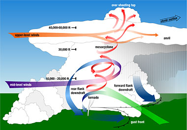
Non-supercell tornadoes are circulations that form without a rotating updraft. One non-supercell tornado is the gustnado, a whirl of dust or debris at or near the ground with no condensation funnel, which forms along the gust front of a storm. Another non-supercell tornado is a landspout. A landspout is a tornado with a narrow, rope-like condensation funnel that forms when the thunderstorm cloud is still growing and there is no rotating updraft - the spinning motion originates near the ground. Waterspouts are similar to landspouts, except they occur over water. Damage from these types of tornadoes tends to be F2 or less.
» More About VISUALIZING ROTATION
How do tornadoes form?
Scientists have learned a lot about tornadogenesis from theoretical studies, field projects and physical models – but tornadogenesis – the way tornadoes form – has vexed researchers for decades.
SUPERCELL TORNADOGENESIS
A rotating updraft is a key
to the development of a supercell, and eventually a tornado. There are
many ideas about how this rotation begins. One way a column of air can
begin to rotate is from wind shear – when
winds at two different levels above the ground blow at different speeds
or in different directions.
An example of wind shear that can eventually create a tornado is when winds at ground level, often slowed down by friction with the earth's surface, come from the southwest at 5 mph. But higher up, at 5000 feet above the same location, the winds are blowing from the southeast at 25 mph! An invisible "tube" of air begins to rotate horizontally. Rising air within the thunderstorm tilts the rotating air from horizontal to vertical – now the area of rotation extends through much of the storm.
Once the updraft is rotating and being fed by warm, moist air flowing in at ground level, a tornado can form. There are many ideas about this too.
» More About SUPERCELL TORNADOGENESIS
We still have many questions. Scientists know from field studies that perhaps as few as 20 percent of all supercell thunderstorms actually produce tornadoes. Why does one supercell thunderstorm produce a tornado and another nearby storm does not? What are some of the causes of winds moving at different speeds or directions that create the rotation? What are other circulation sources for tornadoes? What is the role of downdrafts (a sinking current of air) and the distribution of temperature and moisture (both horizontally and vertically) in tornadogenesis? Scientists hope to learn more about the processes that create wind shear and rotation, tilt it vertically, and concentrate the rotation into a tornado when they participate in a large field experiment in 2007.
And, since not all tornadoes come from supercells, what about tornadogenesis in non-supercell thunderstorms?
NON-SUPERCELL TORNADOGENESIS
A non-supercell tornado
does not form from organized storm-scale rotation. These tornadoes form
from a vertically spinning parcel of air already occurring near the ground,
about 1-10 km in diameter, that is caused by wind shear from a warm,
cold, or sea breeze front, or a dryline. When an updraft moves over the
spinning, and stretches it, a tornado can form. Eastern Colorado experiences
non-supercell tornadoes when cool air rushes down off the Rocky Mountains
and collides with the hot dry air of the plains. Since these types
of tornadoes happen mostly over scarcely populated land, scientists are
not sure how strong they are, but they tend to be small. Waterspouts
and gustnadoes are formed in this way too.
HOW DOES NSSL CONTRIBUTE?
Tornadogenesis
NSSL scientists are working to understand the origins of tornadoes in thunderstorms
through the use of theory. The research focuses on understanding how the
local environment around the storm and internal processes within the storm
produce tornadoes. New insight into these processes can then be incorporated
into NSSL's warning decision technologies to help improve warnings for
tornadoes and severe storms.
Field Observations
NSSL scientists go into the field to look for specific processes in storms,
like observing how tornadoes form, and to test theories and hypotheses.
Storm modeling
Analysis of detailed data sets collected during storm intercept projects
provides invaluable knowledge of storm dynamics. This information helps
provide a coherent picture of storm structure that can be used in modeling
tornadoes and tornado features. The COMMAS model, co-developed by an NSSL
researcher can simulate a three-dimensional supercell thunderstorm.
