|
|
| |||||||||
|
Compact Water Vapor DIAL (CODI)The Need for Water Vapor MeasurementsA thorough understanding of water vapor in the lower troposphere (the first few kilometers above the earth's surface) is essential for predicting both the weather and the global climate. Knowledge of the complex structure of low altitude water vapor is needed to accurately forecast precipitation and severe storms. As the primary greenhouse gas, water vapor data is also critical to climate (e.g. global warming) studies. Currently, moisture profiles are obtained primarily from regular, twice-daily launchings of radiosondes (balloon-mounted instruments) or from satellite retrievals. The radiosonde launches from more than 100 sites across the nation require considerable cost and manpower, and the resulting data profiles, taken once every 12 hours, are inadequate to resolve the highly variable low level water vapor field. The satellite measurements have limited vertical resolution at low altitudes. Optical probing of the atmosphere using either differential absorption lidar (DIAL) or Raman lidar techniques has also been employed to measure water vapor profiles with good vertical resolution (better than 500 m) from both ground-based and air-based platforms. However, the instruments used to obtain these observations are typically highly complex, expensive research instruments. A lidar is a laser-based remote sensing instrument. The goal of this project is to develop a compact, low-cost, eye-safe, automated lidar which can continuously profile water vapor. Such lidars could be widely deployed resulting in considerably more data for improved weather forecasting and climate modeling. Lidars, in combination with lower tropospheric radar profilers, could be used to measure moisture transport. This instrument measures water vapor concentrations using the DIfferential Absorption Lidar (DIAL) technique. Instrument DesignThe application of emerging diode laser technology to DIAL systems offers the promise of deployable, unattended instruments for continuous water vapor profiling in the lower troposphere. Such small systems could be constructed and deployed at costs roughly equivalent to radar wind profilers. The lidar water vapor measurements at low altitudes can be combined with observations of column-integrated water vapor obtained from ground-based radiometer or Global Positioning System methods to improve the vertical resolution and accuracy of water profiling estimates.
The laser characteristics required for acceptable DIAL performance from a low-power system include stable single frequency light with a TEM∞ mode, pulse durations of less than 1 µs, no pre-pulse light and a pulse repetition frequency near 10 kHz. An all solid-state laser system can have the advantages of simplicity, compactness, stability and energy-efficiency. A broadly tunable laser permits access to the optimum water vapor lines in a wavelength region and also can be switched to different lines as the water vapor density changes. A diode-based laser system is preferred because diode lasers are quite small, simple, rugged, very energy-efficient (~40% QE), and inexpensive to produce in large quantities. Advanced fabrication techniques have resulted in tunable, single frequency diodes for applications requiring high spectral quality. Eye safety can be achieved by working in the infrared and by expanding the transmitted laser beam. Status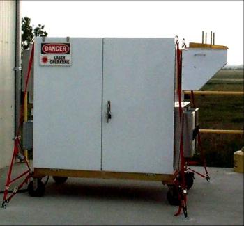
Photograph of CODI. 
Specifications for CODI. 
Nighttime comparison of a DIAL vertical profile with radiosonde derived values. The DIAL data are a 30-min average. CODI (for COmpact DIAL), is a prototype automated ground-based DIAL which continuously measures water vapor profiles to several kilometers above ground. We built this lidar in collaboration with NASA Goddard Space Flight Center and NCAR . The lidar has a weatherproof, temperature-controlled housing. A turning mirror permits the laser beam to be transmitted at any angle from the horizontal to the vertical. The lidar has an eye-safe laser transmitter, a receiver, and computerized electronics for data-taking, monitoring, and synchronization. The transmitter is based on an infrared pulsed diode (flared) amplifier seeded by a cw tunable single-frequency diode laser. Key elements of the receiver include a narrow-band filter to block sky background light and a highly sensitive photon-counting detector.
Nighttime DIAL measurements were successfully compared with data from radiosondes and ground-based in situ sensors to evaluate the performance of CODI including its stability, accuracy and resolution. These measurements show that the DIAL works well in an unattended mode. In general, the nighttime water vapor measurements have at least 15% precision and are processed with 30-minute averaging times, 180-m range gates, and a range of about two kilometers. Longer ranges can be obtained by increasing the averaging. The lidar single-channel backscatter profiles also provide cloud base heights and qualitative measurements of aerosols. The lidar design and more measurements are described in detail in the 2004 Applied Optics paper referenced below. The measurements demonstrated the need for several system improvements. High priority improvements will be to obtain a more powerful laser to enhance the lidar's resolution, "near field" optics to measure the water vapor profile below 800 m, and better climate control for the lidar housing. Together, these upgrades will make the lidar a prototype instrument capable of 24-h ground-based measurements in a variety of conditions. Funding for this project has been provided by NOAA ETL, NOAA OGP, NSF/NCAR USWRP and NASA GSFC. References
Web page last updated 16 December 2004. | ||||||||||
|
 ESRL Home |
PSD/ETL Home |
About PSD |
Programs |
Observing Systems |
About Our Transition |
Search |
Staff ESRL Home |
PSD/ETL Home |
About PSD |
Programs |
Observing Systems |
About Our Transition |
Search |
Staff
|
