Skip Navigation Links weather.gov   
NOAA logo - Click to go to the NOAA homepage National Weather Service   NWS logo - Click to go to the NWS homepage
National Hurricane Center
Local forecast by
"City, St" or "ZIP"

 
Get Storm Info
   Satellite | Radar
   Aircraft Recon
   Advisory Archive
   Experimental
   Mobile Products
   E-mail Advisories
   Audio/Podcasts
   GIS Data | RSS XML/RSS logo
   Help with Advisories
Marine Forecasts
   Atlantic and E Pacific
   Forecast and
   Analysis Tools

   Help with Marine
Hurricane Awareness
   Be Prepared | Learn
   Frequent Questions
   AOML Research
   Hurricane Hunters
   Saffir-Simpson Scale
   Forecasting Models
   Eyewall Wind Profiles
   Glossary/Acronyms
   Storm Names
   Breakpoints
Hurricane History
   Seasons Archive
   Forecast Accuracy
   Climatology
   Most Extreme
About the NHC
   Mission and Vision
   Personnel | Visitors
   NHC Virtual Tour
   Library
   Joint Hurr Testbed
   The NCEP Centers
Contact UsHelp
FirstGov.gov is the U.S. Government's official Web portal to all Federal, state and local government Web resources and services.

Definition of the NHC Track Forecast Cone


Definition:

The cone represents the probable track of the center of a tropical cyclone, and is formed by enclosing the area swept out by a set of circles (not shown) along the forecast track (at 12, 24, 36 hours, etc). The size of each circle is set so that two-thirds of historical official forecast errors over a 5-year sample fall within the circle. The circle radii defining the cones in 2008 for the Atlantic and eastern North Pacific basins are given in the table below.

One can also examine historical tracks to determine how often the entire 5-day path of a cyclone remains completely within the area of the cone. This is a different perspective that ignores most timing errors. For example, a storm moving very slowly but in the expected direction would still be within the area of the cone, even though the track forecast error could be very large. Based on forecasts over the previous 5 years, the entire track of the tropical cyclone can be expected to remain within the cone roughly 60-70% of the time.

Radii of NHC forecast cone circles for 2008, based on error statistics from 2003-2007:

Forecast Period
(hours)

2/3 Probability Circle,
Atlantic Basin
(nautical miles)

2/3 Probability Circle,
Eastern North Pacific Basin
(nautical miles)

12 39 36
24 67 66
36 92 92
48 118 115
72 170 161
96 233 210
120 305 256

Example Graphic of 5-Day Track Forecast Cone:
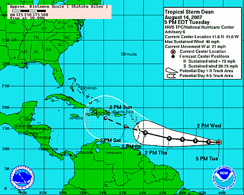
Tropical Cyclone Track and Watches/Warnings
image example for Tropical Storm Dean
Click to Enlarge


Quick Navigation Links:
NHC Active Storms  -  Atlantic and E Pacific Marine  -  Storm Archives
Hurricane Awareness  -  How to Prepare  -  About NHC  -  Contact Us

NOAA/ National Weather Service
National Centers for Environmental Prediction
National Hurricane Center
Tropical Prediction Center
11691 SW 17th Street
Miami, Florida 33165-2149 USA
nhcwebmaster@noaa.gov
Disclaimer
Credits
Information Quality
Glossary
Privacy Policy
Freedom of Information Act (FOIA)
About Us
Career Opportunities
Page last modified: Monday, 05-May-2008 14:39:36 GMT