| TEXT ONLY VERSION | NATIONAL
HURRICANE CENTER |
 |
 |
|
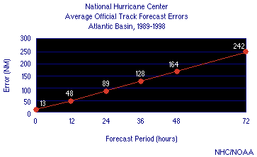
Hurricane forecasters analyze large amounts of data, including conflicting computer model results, and come up with their best estimate of a three-day track and intensity forecast. Just as it is easier to predict where you will be 12 hours from now as opposed to 72 hours, it is easier to predict where a hurricane will be right before it makes landfall (although hurricanes can, and do, unexpectedly alter course). The figure below shows that, at shorter forecast time periods, the forecast track error is fairly small, but when the forecast is farther in the future, the error increases significantly. Knowing these estimated errors can help you assess your potential risk.
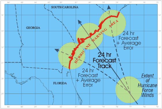
Forecasters convey track uncertainty through the strike probability tables and strike probability graphics which show the areas likely to be affected by the tropical cyclone. These products are based on the current best forecast track and the past distribution of errors. They are created to indicate the statistical chance that the hurricane center will pass within 65 NM (75 mi) of a location within 3 days of the initial forecast time. The maximum probabilities by forecast period are displayed in the table below and are based on NHC's average forecast errors for the various periods. For example, if a hurricane is expected to make landfall in 48 hours at New Orleans, the highest the probability can be is 25%. Most coastal locations need to start evacuations by 48 hours in order to have them completed before the tropical storm-force winds arrive. In most cases, if you wait until the probability is 50% or greater, it will be too late to take effective actions. Consequently, this table provides critical information for decision making.
Hurricane
Intensity Forecasts
|
|
|||||||||||||||||||
|
Visit these websites to learn more |
|