JULY 19, 1983
DERECHO
"The
I-94 Derecho"
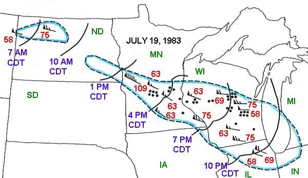
Figure 1. Area affected by the July 19, 1983 derecho event (outlined in blue). Curved black lines represent the locations of the squall line (based on radar reflectivity imagery) at three hourly intervals. The "black dots" represent personal injuries related to the derecho winds. The flag symbols represent measured wind gusts with the direction of the wind from the flags towards the other end of the staff. The maximum wind gusts (red numbers) are in mph.
Near dawn on the morning of Tuesday, July 19, 1983, a bow echo moved out of northeastern Montana and began producing damaging winds in northwestern North Dakota (ND). The airport weather stations at Williston and Minot reported wind gusts to 58 and 75 mph, respectively (Fig. 1) . This would be the beginning of a derecho event that would proceed across the northern Great Plains and Upper Mississippi Valley and reach the Chicago metropolitan area by late in the evening on July 19th.
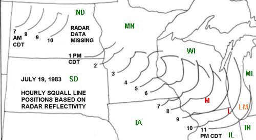
Figure 2. Hourly positions of the squall line associated with the "I-94 Derecho". Initially, it appears as a single bow echo, but later expands into a longer line with a few embedded bow echoes. The line of storms that develops on the north edge of the squall line and perpendicular to it is a common feature associated with "progressive" derecho bow echo systems and is called a warm advection wing (Smith 1990). Such features typically produce heavy rain rather than strong winds.
The single bow echo continued to cause occasional damage as it moved across North Dakota during the morning hours. By early afternoon it was entering Minnesota (MN) and it began expanding in scale. It developed into a squall line with two and sometimes three bow echo segments as it moved across Minnesota and Wisconsin (WI) with Interstate Highway I-94 near its center axis (Fig. 2). Winds over 100 mph were recorded at the Alexandria Airport in west central Minnesota and planes and hangers were damaged and destroyed. As the storm moved southeastward it continued to cause much damage. In the Minneapolis/St. Paul metropolitan region about 250,000 customers lost electrical power.
Trees were blown over and buildings damaged as the derecho raced through Wisconsin. In Madison, Wisconsin (red "M" on Fig. 2), Dr. Robert Schlesinger, a research meteorologist specializing in convective storm modeling at the University of Wisconsin, observed its approach from the southeastern shore of Lake Mendota and took pictures of the laminar layered "shelf cloud" and gust front approaching from the northwest (Figs. 3 and 4). As the strong derecho winds came ashore several piers were destroyed. At the University of Wisconsin campus (partially visible in Fig. 4) several buildings were damaged and windows were blown out of the second and third stories of the Memorial Library. Tiles from the library roof were blown off and landed several blocks to the southeast. The strong winds resulted in waves roughly 4 feet high on Lake Mendota and even well after the strong winds had diminished, unusually large "whitecaps" continued on the agitated lake (Fig. 5).
Thirty four people were injured in Minnesota and Wisconsin from this storm. Of these injuries, 12 were from mobile homes being blown over and 8 were from trees falling on people and vehicles.

Photo by Robert Schlesinger, used with permission
Figure 3. Photograph taken just before sunset on Tuesday, July 19, 1983 looking towards the west-northwest from the southeastern shore of Lake Mendota near the north end of Carroll Street in Madison, Wisconsin. The laminar layered shelf cloud associated with the derecho gust front is approaching rapidly from the northwest. Several sailboats can be seen on the lake.
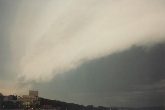
Photo by Robert Schlesinger, used with permission
Figure 4. Photograph taken from the same place as Fig. 3 a few minutes after Fig. 2 and looking towards the west as the derecho gust front and shelf cloud are crossing Lake Mendota towards the University of Wisconsin campus.

Photo by Robert Schlesinger, used with permission
Figure 5. View of Lake Mendota looking northwest from near where Fig. 3 was taken and approximately 45 minutes after the derecho gust front passed through the area. Note the large waves with white caps that are still present on the lake well after the strongest winds have passed by.
The bow echo system and derecho began moving into northeastern Illinois (IL) between 9 and 10 PM CDT. National Weather Service meteorologist Richard Koeneman experienced this derecho event and wrote about his experiences in his weather diary. He had noted that it was a "warm and humid" evening on July 19, 1983 and the wind was "dead calm". From his home in Lindenhurst, Illinois (red "L" on Fig. 2 near the Wisconsin border north of Chicago) he had a good view of the storm approaching since there was a wide open lake behind his backyard. He noted lightning visible on the horizon to the north and northwest of his home about 9:30 PM. At 9:40 PM, with the wind being calm in his backyard, he could hear the "rushing" noise of strong winds approaching from the northwest. Three minutes later the gust front hit his house and within a minute or two he estimated that the wind speed was gusting to 70 mph. The house was shuddering and Richard was worried that it might start flying apart. The house lost electrical power and in his weather diary he noted that the temperature had dropped from 83 deg. F at 9:30 PM to 68 deg. F by 9:50 PM. He also noted that it was the first time he had ever been able to hear the noise associated with an approaching gust front. And in this case it was a gust front that had already traveled for hundreds of miles but was still quite intense as it passed by Richard's home.
The derecho winds were still intense as they moved into the northwest side of the Chicago metropolitan area and a gust to 69 mph was recorded at O'hare International Airport at 10:10 PM CDT. After this the bow echo system began weakening and the winds only gusted to 55 mph as the system passed over Midway Airport on Chicago's south side. The derecho finally died out over northwestern Indiana (IN) near midnight on the evening of July 19th, 1983 after traveling 1000 miles in 18 hours at an average speed of 56 mph.
(References.....Johns and Hirt, 1985; Storm Data for July 1983)
Back to the Historic Derecho Event List
Back to the Types of Derechos question
Back to the Derecho Facts Page