NOAA's Storm Prediction Center (SPC) provides short-term forecasts of hazardous weather to the public and the National Weather Service's local field offices. The SPC, formerly known as the National Severe Storms Forecast Center, is a component of the National Centers for Environmental Prediction (NCEP), which also includes the Tropical Prediction Center (National Hurricane Center) in Miami, FL. In addition to issuing tornado and severe thunderstorm watches for the 48 contiguous states, SPC also produces regularly-scheduled severe weather outlooks and updates on various forms of hazardous weather including heavy rain and winter storms. Future plans include products to address high wind, dense fog, blowing dust, air pollution, and volcanic ash events. The SPC operates continuously around the clock, with an on-duty staff that varies between 3 and 5 forecasters depending on the time of day.
Early Severe Weather Forecast Efforts
Although SPC's immediate history dates to the early 1950s, the roots of severe weather prediction in the United States may be traced much further. The development of a centralized weather forecast program by the U. S. Army Signal Corps in 1870 made apparent the need for improved documentation and increased understanding of destructive local storms. Leading the Corps in this effort was Sgt. John P. Finley. In the mid 1880s, Finley organized a team of more than 2000 "reporters" to document tornadoes and their associated weather conditions over the central and eastern United States. Using the data thus collected, Finley assembled maps of characteristic tornado-producing weather patterns which were then used to issue tornado "alerts." Finley's forecasts fell out of favor, however, in the late 1880s because the Corps (and later the Weather Bureau) felt that mention of the word "tornado" provoked undue fear and panic amongst the public.
Little progress was made in the understanding and forecasting of severe local storms during the first part of the 1900s. Although forecasts occasionally mentioned the potential for severe weather, official policy continued to prohibit use of the word "tornado" in Bureau forecasts. The arrival of airplane and kite observations sparked renewed interest in severe weather in the 1920s and 1930s. Interest further increased with the development of radiosondes and the growth of military aviation in the 1940s. Nevertheless, even though the ban on the word "tornadoes" in forecasts was lifted in 1938, very few forecasts made mention of tornadoes throughout the 1940s.
The late 1940s witnessed the single event that most directly led to the establishment of a centralized severe weather forecasting program in the United States. Using the work of researchers such as A. K. Showalter and J. R. Fulks, as well as their own investigation of the conditions which produced a damaging tornado at Tinker Air Force Base five days earlier, Air Force weather officers E. J. Fawbush and R. C. Miller successfully predicted the fortuitous occurrence of another tornado at the Base on 25 March 1948. The forecast's accuracy drew considerable attention: Fawbush and Miller were soon responsible for tornado prediction over much of the central United States. Three years later, the Severe Weather Warning Center (SWWC), a formal Air Weather Service unit with responsibility for all Air Force sites on the U.S. mainland, was established under their leadership.
The Birth of SELS
The success of the Air Force tornado program --- along with media pressure to adopt the Air Force program for civilian use --- led the Weather Bureau to establish its own severe weather unit on a trial basis at the Weather Bureau-Army-Navy (WBAN) Analysis Center in Washington, DC in March 1952. Fifteen forecasters, including members of the WBAN analysis staff and the Bureau's central office and field stations, were selected to staff the unit. Several weeks of techniques development and practice forecasts preceded the release of the unit's first public tornado "bulletin" on 17 March. This forecast mentioned the possibility of tornadoes in parts of Texas, Oklahoma, Arkansas and Louisiana during the late night and early morning hours of the 17th and 18th. Although two tornadoes did occur in Texas, they were not in the outlook area. The group experienced more success with its second forecast, which was issued on 21 March for parts of east Texas, southern Arkansas, southeast Oklahoma and northern Louisiana. An update extended the forecast into parts of Tennessee, Kentucky and Indiana. Thirty-six tornadoes which began during the afternoon and continued through the night caused 208 deaths in Arkansas, Mississippi, Louisiana, Alabama, Tennessee, Kentucky and Missouri.
The WBAN severe weather operation became permanent on 21 May 1952 when the group was formally recognized as the Weather Bureau Severe Weather Unit (SWU). Forecast responsibility which had been limited to tornadoes was now expanded to include other forms of severe convective weather such as large hail, high winds and extreme turbulence.
Five permanent SWU forecasters were selected during the summer of 1952 to provide around-the-clock shift coverage; temporary staff continued to cover shifts as necessary until the permanent staffing was completed in September. The new forecasters were young; most had been with the Weather Bureau less than ten years and had attended meteorology school with the military during World War II. Comparatively new forecasters were intentionally chosen as it was thought that they would be less likely to harbor preconceived notions about severe storm prediction. Three of the original five permanent SWU forecasters left the group before its move to Kansas City in 1954 Only Joseph Galway, the first forecaster to join the unit and the originator of the well-known "lifted index," remained with the SWU after 1955.
Although the first few severe weather forecasts were issued directly to the public via teletype, tornado forecasts through the remainder of the year were released by Weather Bureau district offices --- usually after direct consultation with the SWU. Consecutively-numbered "Severe Weather Bulletins," the forerunner of today's "watches," were initiated in May 1952. As is the case today, the objective was to keep the threat areas as small as possible, with only as much lead time as necessary to allow for adequate public response. These early "watches" were not necessarily parallelograms; some were odd-shaped trapezoids or even circles.
The Severe Weather Unit evolved rapidly in 1953 --- a year that coincidentally produced an unusually large number of tornadoes. In January, an experimental program to issue daily outlooks of the severe weather potential of the upcoming day was initiated. These trial outlooks, called "Severe Weather Discussions," were intended as guidance for selected Weather Bureau district offices and covered the 1200 to 2400 CST time period. They became operational in February and were renamed "Convective Outlooks" when regular transmission began on the "Service A" teletype network in April 1955.
The unit was renamed the Severe Local Storm Warning Center (SELS) on 17 June 1953 --- shortly after death-dealing tornadoes struck Flint, MI, Waco, TX and Worcester, MA. Devastating storms on 7-9 June alone claimed more than 200 lives. These events tested the endurance of the Center's relatively inexperienced staff. Although the storms on 7- 8 June were well forecast, the Worcester tornado on the 9th caught forecasters by surprise: one requested (and was granted) a transfer out of the unit. By the end of the year, SELS supervisor Kenneth M. Barnett had also requested a transfer as the group came under increasing scrutiny regarding both the size and accuracy of its forecasts. Because of pressure to issue smaller "bulletins," tornado forecast areas decreased in size from nearly 38,000 square miles in 1952 to 27,000 square miles during the first half of 1953. (By comparison, average tornado and severe thunderstorm watches today cover about 25,000 square miles).
The Move to Kansas City
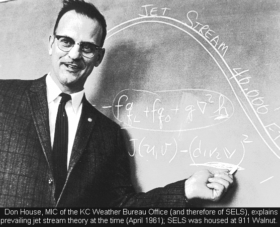
SELS continued to change in 1954. Staffing increased to include a supervisor, 7 forecasters, 6 chartists, a research forecaster and a research assistant. In addition, a new supervisor, Donald C. House, was selected to replace Barnett. House's enthusiasm for severe weather was immediately apparent: on busy days he often worked the forecast desk. Under his direction, the size of tornado forecasts continued to decrease; average "bulletin" size in 1954 dropped to just 15,000 square miles. House also strived to enhance the scientific basis of the unit by furthering staff research efforts started under Barnett. SELS meteorologists Ferdinand Bates, Robert Beebe, James Carr, Donald Foster, Joseph Galway, Bernard Magor, Jean Lee and others made a series of lasting contributions to the literature on severe weather forecasting beginning in the mid 1950s. House also stressed the need to incorporate high-level (jet stream) data in the preparation of forecasts, based on the work of Herbert Riehl. House's efforts were to a large extent responsible for the respect which SELS enjoyed within the Weather Bureau by the late 1950s.
Another important 1954 change was SELS' relocation from the Washington Analysis Center to the Bureau's Kansas City district forecast office. The move was made partly in response to media pressure to locate the office in a region prone to severe weather. Kansas City was also a major teletype circuit switching center. By locating there, SELS could have more timely access to surface observations. But the move also recognized an existing Kansas City-severe weather connection that had, in fact, been established in January 1952, when J. R. Lloyd, meteorologist-in-charge of the Kansas City office, established a small group to test the severe weather forecasting techniques of Fawbush and Miller. Oklahoma was part of Kansas City's forecast area, and Lloyd's effort was the subject of close scrutiny since pressure was being mounted to have the Weather Bureau issue tornado forecasts like those of the Air Force. Lloyd intended to use the results of the test group to issue actual forecasts beginning in 1953 or 1954. His efforts were instrumental in hastening Washington's decision to issue routine severe weather forecasts in May 1952.
The success of the Air Force and Weather Bureau severe weather programs, in addition to educational efforts which included brochures and presentations on tornado safety, significantly reduced public opposition to tornado forecasts during the mid 1950s. Many in fact praised the forecasts as a means of saving lives. During this period, a typical SELS tornado forecast would read as follows: "...possibility of an isolated tornado along and thirty miles either side of a line from Amarillo, TX to 20 miles north of Gage, OK, from 5:15 to 9:00 PM." Such a forecast would have first been telephoned to the district offices(s) involved. If it was agreed that a public forecast of tornadoes was indeed prudent, the district forecaster would notify the local Weather Bureau offices under his jurisdiction, in addition to the media. If the proposed forecast affected only one district office, that office had final say as to whether or not tornadoes would be mentioned in the public forecast. If, on the other hand, a proposed tornado forecast involved more than one district office, SELS made the final decision. It was not until 1958 that SELS assumed total authority for public tornado and severe thunderstorm forecasts.
Maturity
Throughout the 1950s and early 1960s, all SELS data plotting and analysis was performed by hand. Analysis skills increased significantly with the installation of an IBM 1620 computer in April 1963. The 1620 allowed forecasters to generate diagnostic fields of convergence and divergence that were difficult or impossible to manually compute. Automated plotting of surface and upper air observations commenced with the arrival of a CDC 3100 system in November 1965. This computer was also used for data tabulation and research by the District Forecast Office.
In August 1965, Don House left SELS for a position with the newly-formed Environmental Science Services Administration (predecessor of NOAA), and Allen D. Pearson was appointed as SELS Director. Early the following year, the entire Weather Bureau Office in Kansas City (including SELS and the District Forecast Office) was renamed the National Severe Storms Forecast Center (NSSFC) to better reflect the national scope of the office. In addition, SELS' tornado and severe thunderstorm forecasts were renamed "watches" to more directly correspond with the suite of products issued by the National Hurricane Center. Soon afterward, NSSFC moved from the 9th floor of the "old" Federal Office Building at 9th and Walnut Streets to the 17th floor of new Federal Building at 601 E 12th, where it remained until relocating to Norman, OK in 1997.
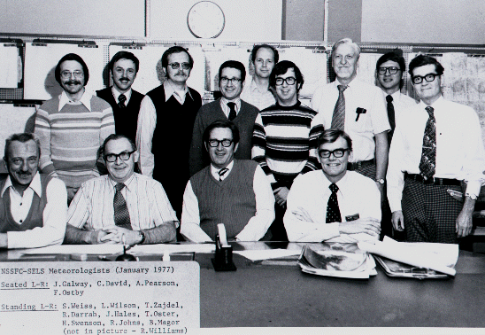
A series of computer upgrades significantly enhanced NSSFC's data processing and communication capabilities during the late 1960s and 1970s. But one of the more important developments of the period occurred with the establishment of the Techniques Development Unit (TDU) in April 1976. This group was formed to assist forecasters with software development and the evaluation of new forecast techniques. It also provided a link to the severe weather research community. TDU's formation marked the first formal research/development program to be associated with SELS/NSSFC since the National Severe Storms Project departed Kansas City to become the National Severe Storms Laboratory in Norman in March 1964.
Frederick P. Ostby became the Director of NSSFC in May 1980, shortly after the transfer of Pearson to Central Region Headquarters. Ostby oversaw NSSFC's entry into the age of interactive computing with the arrival of the Centralized Storm Information System (CSIS) in February 1982. This system enabled forecasters to overlay objective analyses of conventional surface and upper air data with real-time radar and satellite imagery. Watch areas could be formulated directly on the appropriate radar and satellite displays, and different objective analyses could be overlayed at once. Later upgrades allowed the user to "roam" and "zoom" across the entire nation. Mesoscale Discussions, unscheduled products used to describe ongoing convective trends and hazardous weather situations, were instituted in 1986 --- partly in response to the availability of timely analyses on CSIS.
As part of a decade-long effort to modernize the nation's weather services, NSSFC was renamed the Storm Prediction Center (SPC) in October 1995, with former TDU chief Joseph T. Schaefer selected to succeed Ostby as Director. Early in 1997 and after more than 40 years of severe weather forecasting in Kansas City, the Center relocated to Norman, OK. There, the SPC joined the organization it had spawned three decades earlier --- the National Severe Storms Laboratory --- on the North Base campus of the University of Oklahoma (OU) .
In September 2006 the SPC moved once again to join several other federal, state and OU weather organizations in the new National Weather Center (NWC). Located on the OU Research Campus at State Highway 9 and Jenkins Avenue, the NWC provides a unique opportunity for collaboration with other organizations to improve the forecasting and understanding of severe convective weather.

Commemorate the golden anniversary of tornado forecasting